Sainte-Anne Parish, New Brunswick
Sainte-Anne
St. Anne, Ste. Anne | |
|---|---|
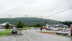 Sainte-Anne-de-Madawaska village | |
 Location within Madawaska County, New Brunswick. | |
| Coordinates: 47°25′N 67°51′W / 47.41°N 67.85°W | |
| Country | |
| Province | |
| County | Madawaska |
| Erected | 1877 |
| Area | |
| • Land | 368.89 km2 (142.43 sq mi) |
| Population (2016)[1] | |
| • Total | 964 |
| • Density | 2.6/km2 (7/sq mi) |
| • Change 2011-2016 | |
| • Dwellings | 509 |
| Time zone | UTC-4 (AST) |
| • Summer (DST) | UTC-3 (ADT) |

Sainte-Anne is a civil parish in Madawaska County, New Brunswick, Canada.[2]
For governance purposes it is divided between the village of Sainte-Anne-de-Madawaska and the local service district of the parish of Sainte-Anne[3] (which further includes the special service area of Seigas),[3] both of which are members of the Northwest Regional Service Commission (NWRSC).[4]
Origin of name[]
The parish takes its name from the church.[5]
History[]
Sainte-Anne was erected in 1877 as Saint Ann's Parish from Saint-Basile and Saint-Léonard Parishes.[6]
In 1920 Sainte-Anne's boundaries were revised.[7] The same act erected Rivière-Verte Parish from Saint-Léonard, so part of Sainte-Anne may have been included in Rivière-Verte.
In 1922 Notre-Dame-de-Lourdes Parish was erected from part of Sainte-Anne.[8] The name appeared as Saint Ann in the description of Notre-Dame-de-Lourdes.
In 1946 the name was changed to Sainte Anne and the parish was affected by the major reorganisation of Madawaska County parish boundaries.[9]
In 1973 the name was legally changed to Sainte-Anne.[10]
Boundaries[]
Sainte-Anne Parish is bounded:[2][11][12][13]
- on the northeast by the Restigouche County line;
- on the east and southeast, beginning at the meeting point of Restigouche County, Madawaska County, and Victoria County, then running south about 3.7 kilometres along the Madawaska-Victoria line, then southwesterly about 15 kilometres along the prolongation of the southeastern line of four grants on the southeastern side of Martin Road near Miller Line Cache, then northwesterly about 600 metres to Martin Road near its end, then southwesterly about 1.5 kilometres along Martin Road to the northeastern line of a grant to Noël Ruest, then southeasterly to the southeastern line of Ruest, then generally southwesterly along the southeastern line of grants along Miller Road to Ruisseau Noir Road, then southwesterly along the southeastern line of a grant to Hervé Dubé to the northeastern line of a grant to Edmond Dubé, then southeasterly to the easternmost corner of Edmond Dubé, then generally southwesterly the rear line of grants along Martin Road, then generally southwesterly along the rear line of grants along the northwestern side of Ruisseau Noir Road in Notre-Dame-de-Lourdes Parish to the easternmost corner of a grant to Honoré Martin on the northeastern side of Denis Lebel Road, then southwesterly along the rear line of grants at the end of Denis Lebel Road to the rear line of grants on the northeastern side of Jacques Martin Road and its prolongation along a former Crown reserve road, the tier now straddling Route 2, then southeasterly along the rear line of the tier to the easternmost corner of a grant to Noé Cyr, about 900 metres northwest of Notre-Dame-de-Lourdes Road, then southwesterly to the rear line of grants on the Saint John River, at a point about 50 metres northwest of the Route 2 bridge over the Siegas River, then southeasterly along the rear line of the Saint John River tier to the easternmost corner of a grant to Andrew Michaud, about 600 metres northwesterly of Grande Rivière and about 400 metres northeast of Route 2, then southwesterly along the Michaud grant to the international border within the Saint John River;
- on the southwest by the international border within the Saint John River;
- on the northwest, beginning on the international border in the Saint John River on the prolongation of the northwestern line of a grant to Louis Pelletier and L. Moreau, then northeasterly along the prolongation and the Pelletier & Moreau grant, about 1.1 kilometres northwest of Lavoie Road, to its rear line, on the southwestern line of a grant John R. Lynch, on the northeastern side of the prolongation of Moreau Road, then northwesterly about 100 metres to the westernmost corner of the Lynch grant, then about 2.5 kilometres northeasterly, with a slight curve near the middle, along the Lynch grant and a grant to Pierre Ringuet, to the Quisibis River, then about 50 metres downstream, then northeasterly along the northeastern line of Lot G within a five-lot grant to John M. Stevens to the rear line of grants on the southwestern side of Montagne-de-la-Croix Road, then southeasterly about 1.3 kilometres along the rear line of the tier, then northeasterly along the southeastern line of a grant to Théodule Clavette to Montagne-de-la-Croix Road, then southeasterly along the road about 550 metres to the westernmost corner of a grant to Ludger Guerrette, then northeasterly about 8.7 kilometres along the southeastern line of Guerrette and its prolongation to the southwestern line of the Third Tract granted to the New Brunswick Railway Company, then northwesterly about 2.1 kilometres to the westernmost corner of the Third Tract, then northeasterly along the Third Tract to the Restigouche County line.
Communities[]
Communities at least partly within the parish.[11][12][13] bold indicates an incorporated municipality
- Fourche-à-Clark
- Miller Line Cache
- Prime
- Quisibis
- Rang-des-Deschêne
- Sainte-Anne-de-Madawaska
- Siegas
- Siegas Lake Settlement
- Sirois
Bodies of water[]
Bodies of water[a] at least partly in the parish.[11][12][13]
- Gounamitz River
- Little Main Restigouche River
- Quisibis River
- Saint John River
- Siegas River
- Fourche à Clark
- Mud Lake
- Quisibis Lake
- Siegas Lake
Islands[]
Islands at least partly in the parish.[11][12][13]
- Quisibis Island
Other notable places[]
Parks, historic sites, and other noteworthy places at least partly in the parish.[11][12][13][14]
- Martial Brook Protected Natural Area
Demographics[]
Parish population total does not include Sainte-Anne-de-Madawaska
Population[]
|
Language[]Mother tongue (2016)[1]
|
See also[]
Notes[]
- ^ Not including brooks, ponds or coves.
References[]
- ^ a b c d "Census Profile, 2016 Census: Sainte-Anne, Parish [Census subdivision], New Brunswick". Statistics Canada. Retrieved September 23, 2019.
- ^ a b "Chapter T-3 Territorial Division Act". Government of New Brunswick. Retrieved 13 November 2020.
- ^ a b "New Brunswick Regulation 84-168 under the Municipalities Act (O.C. 84-582)". Government of New Brunswick. Retrieved 19 July 2020.
- ^ "Communities in each of the 12 Regional Service Commissions (RSC) / Les communautés dans chacune des 12 Commissions de services régionaux (CSR)" (PDF), Government of New Brunswick, July 2017, retrieved 2 February 2021
- ^ Ganong, William F. (1896). A Monograph of the Place-Nomenclature of the Province of New Brunswick. Royal Society of Canada. p. 267. Retrieved 17 March 2021.
- ^ "40 Vic. c. 30 An Act to erect parts of the Parishes of Saint Leonard, Saint Basil, Madawaska, and Saint Francis, in the County of Madawaska, into three additional Parishes.". Acts of the General Assembly of Her Majesty's Province of New Brunswick. Passed in the Month of March 1877. Fredericton: Government of New Brunswick. 1877. pp. 125–128. Available as a free ebook from Google Books.
- ^ "9 Geo. V c. 55 An Act to amend Chapter 2 of the Consolidated Statutes, 1903, respecting the division of the Province into Counties, Towns and Parishes.". Acts of the Legislative Assembly of New Brunswick Passed in the Month of April 1919. Fredericton: Government of New Brunswick. 1919. pp. 258–265.
- ^ "11 Geo. V c. 18 An Act to Amend Chapter 2 of the Consolidated Statutes, 1903, respecting the division of the Province into Counties, Towns and Parishes.". Acts of the Legislative Assembly of New Brunswick Passed in the Month of April 1921. Fredericton: Government of New Brunswick. 1921. pp. 155–166.
- ^ "10 Geo. VI. c. 95 An Act to amend Chapter 2 of the Revised Statutes, 1927, respecting the division of the Province into Counties, Towns and Parishes, in so far as it relates to the County of Madawaska.". Acts of the Legislative Assembly of New Brunswick Passed During the Session of 1946. Fredericton: Government of New Brunswick. 1946. pp. 321–339.
- ^ "Chapter T-3 Territorial Division Act". Revised Statutes of New Brunswick 1973 Volume IV. Fredericton: Government of New Brunswick. 1973. pp. 1–70.
- ^ a b c d e "No. 21". Provincial Archives of New Brunswick. Department of Natural Resources and Energy Development. Retrieved 16 June 2021. Remainder of parish on maps 22, 34, 35, and 44 at same site.
- ^ a b c d e "080" (PDF). Transportation and Infrastructure. Government of New Brunswick. Retrieved 16 June 2021. Remainder of parish on mapbooks 081, 100, 101, 121, and 122 at same site.
- ^ a b c d e "Search the Canadian Geographical Names Database (CGNDB)". Government of Canada. Retrieved 16 June 2021.
- ^ "Explore New Brunswick's Protected Natural Areas". GeoNB. Retrieved 2 July 2021.
- ^ Statistics Canada: 1996, 2001, 2006 census
- ^ 2011 Statistics Canada Census Profile: Sainte-Anne Parish, New Brunswick
Places adjacent to Sainte-Anne Parish, New Brunswick | |
|---|---|
| Subdivisions |
|
|---|---|
| Cities | |
| Counties | |
| |
Coordinates: 47°24′36″N 67°51′00″W / 47.41000°N 67.85000°W
- Local service districts of Madawaska County, New Brunswick
- Parishes of Madawaska County, New Brunswick