Sallum
Sallum
As Sallum/Sollum El-Salloum | |
|---|---|
Village/harbour-side town | |
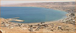 The east-facing centre and (to background) south of the town which is where the coast assumes its overall north direction as throughout the rest of Egypt, though having many headlands much further east. The desert hills are the Akabah el-Kebir. | |
 Sallum Location in Egypt | |
| Coordinates: 31°30′13″N 25°06′54″E / 31.50361°N 25.11500°ECoordinates: 31°30′13″N 25°06′54″E / 31.50361°N 25.11500°E | |
| Country | |
| Governorate | Matruh |
| Elevation (by harbour, downtown) to 200 metres (in associated scarp) | 3 ft (1 m) |
| Population (2006) | |
| • Total | 14,393 |
| Time zone | UTC+2 (EST) |

Sallum, El Salloum, As Sallum or Sollum (Arabic: السلوم Egyptian Arabic pronunciation: [essælˈluːm]) is a harbourside village or town in Egypt. It is along the Egypt/Libyan short north/south aligned coast of the Mediterranean Sea in the far northwest corner of Egypt. It is, geodesically, 8 km (5 mi) east of the border with Libya, and 128 km (80 mi) from the notable port of Tobruk, Libya.
Sallum is mainly a Bedouin community of the families of merchants, fishermen and herdsmen. It has little tourist activity and few organized historical curiosities. It is a key trading center for the local Bedouin community. It has a World War II Commonwealth War Graves Commission cemetery and is 7.5 kilometres (4.7 mi) north of Halfaya Pass.
Sallum is on its own pass, improved since World War II, has become the main pass ascending the related ridge, which obstructs east-west trade. The ridge extends away from its northern part, east-facing sea cliffs, south by 55 kilometres (34 mi), there turning increasingly east. This escarpment is the Akabah el-Kebir, once called the Akabah el Sallum, such as in the 12th century – a descriptor meaning graded (evened out) ascent, then making the name of the town. There are no other roadworthy passes nearby.
Sallum was a small ancient Roman port. Some Roman wells remain locally. Sometimes called Baranis, it should not be confused with the medieval-noted branch of the Berbers, the al-Baranis.
At its southern end scattered homes mark out the end of the Northern coast of Egypt. Amenities include a post office and a National Bank of Egypt branch.
History[]

Early settlement[]
Local people are mentioned in some Roman accounts of Catabathmus Maior/Magnus (referring to the local, obstructive ridge to east-west land trade, Akabah el Solum, or more commonly today el-Kebir, the great). It may have been Plynos Limen and Tetrapyrgia mentioned in less context-clear early courses.
Sallum was the origin for many eastward migrations to Egypt Eyalet and Bilad al-Sham. During the 19th century, one family, migrated first to Tafilah in southern Jordan, and thence to the region of Jaffa. They settled in ancient village of Mulabbis, and lived there for several generations until the establishment of Petah Tikva, the first Zionist colony, in 1878[1][2]
Sovereignty and battles[]
Sallum was part of the Eyalet then Vilayet of Tripolitania, 1551–1911, the year before its fall mainly to Italy. That year, during the Italo-Turkish War, an Anglo-Egyptian force took it over, relieving its garrison, to prevent it falling into Italian hands. When the border between Italian Libya and Egypt was settled by treaty in 1925, Sallum was left on the Egyptian side.[3]
During the Senussi Campaign of World War I, Sallum was captured by the Senussi in November 1915 with Ottoman and German assistance. It was re-taken by the British in March 1916.[4]
In December 1941, during Operation Crusader in World War II (and the two other operations affecting nearby Halfaya Pass) Sallum was the location of fighting between the British Empire and allied Commonwealth forces against German forces; the latter were retreating from gains they had made deeper into Egypt. The Halfaya Sollum War Cemetery was established by the Commonwealth War Graves Commission to inter over 2,000 soldiers who died in the region.
On July 21, 1977, Libya attacked Sallum, after Egypt started the Libyan-Egyptian War.
Solar eclipse[]
Sallum was a destination in the total solar eclipse on March 29, 2006 among expeditions.[5]
Climate[]
Köppen-Geiger climate classification system classifies its climate as hot desert (BWh), as the rest of Egypt, but typically as the northern coast of Egypt, has its temperatures moderated by blowing winds from the Mediterranean Sea.
| hideClimate data for Salum | |||||||||||||
|---|---|---|---|---|---|---|---|---|---|---|---|---|---|
| Month | Jan | Feb | Mar | Apr | May | Jun | Jul | Aug | Sep | Oct | Nov | Dec | Year |
| Record high °C (°F) | 30.3 (86.5) |
33.4 (92.1) |
37.4 (99.3) |
42.4 (108.3) |
44.2 (111.6) |
47.3 (117.1) |
41.7 (107.1) |
47.2 (117.0) |
43.0 (109.4) |
41.4 (106.5) |
36.6 (97.9) |
32.0 (89.6) |
47.3 (117.1) |
| Average high °C (°F) | 18.6 (65.5) |
19.6 (67.3) |
21.4 (70.5) |
24.2 (75.6) |
26.8 (80.2) |
30.0 (86.0) |
31.3 (88.3) |
31.1 (88.0) |
29.6 (85.3) |
27.4 (81.3) |
23.9 (75.0) |
20.2 (68.4) |
25.3 (77.5) |
| Daily mean °C (°F) | 13.8 (56.8) |
14.5 (58.1) |
16.1 (61.0) |
18.6 (65.5) |
21.2 (70.2) |
24.7 (76.5) |
26.2 (79.2) |
26.4 (79.5) |
25.0 (77.0) |
22.6 (72.7) |
18.9 (66.0) |
15.3 (59.5) |
20.3 (68.5) |
| Average low °C (°F) | 9.8 (49.6) |
10.3 (50.5) |
11.8 (53.2) |
14.1 (57.4) |
16.9 (62.4) |
20.3 (68.5) |
21.9 (71.4) |
22.3 (72.1) |
20.9 (69.6) |
18.5 (65.3) |
14.8 (58.6) |
11.3 (52.3) |
16.1 (61.0) |
| Record low °C (°F) | 3.7 (38.7) |
4.8 (40.6) |
6.1 (43.0) |
8.5 (47.3) |
9.9 (49.8) |
14.0 (57.2) |
18.0 (64.4) |
18.4 (65.1) |
15.4 (59.7) |
12.9 (55.2) |
7.3 (45.1) |
6.5 (43.7) |
3.7 (38.7) |
| Average precipitation mm (inches) | 21 (0.8) |
15 (0.6) |
7 (0.3) |
6 (0.2) |
2 (0.1) |
1 (0.0) |
0 (0) |
0 (0) |
0 (0) |
13 (0.5) |
10 (0.4) |
17 (0.7) |
92 (3.6) |
| Average precipitation days (≥ 1.0 mm) | 2.7 | 1.1 | 0.7 | 0.8 | 0.2 | 0.1 | 0.0 | 0.0 | 0.1 | 1.1 | 1.0 | 1.3 | 9.1 |
| Average relative humidity (%) | 59 | 58 | 59 | 58 | 60 | 59 | 62 | 65 | 64 | 62 | 59 | 59 | 60.3 |
| Mean monthly sunshine hours | 217.0 | 211.9 | 279.0 | 297.0 | 306.9 | 369.0 | 393.7 | 378.2 | 327.0 | 300.7 | 219.0 | 210.8 | 3,510.2 |
| Mean daily sunshine hours | 7.0 | 7.5 | 9.0 | 9.9 | 9.9 | 12.3 | 12.7 | 12.2 | 10.9 | 9.7 | 7.3 | 6.8 | 9.6 |
| Source 1: NOAA[6] | |||||||||||||
| Source 2: Arab Meteorology Book (sun only)[7] | |||||||||||||
See also[]
- Halfaya Pass
- Military history of Italy during World War II
- Military history of Egypt during World War II
- Libyan–Egyptian War
Notes[]
- ^ Marom, Roy. A short history of Mulabbis (Petah Tikva, Israel). 151.
- ^ Marom, Roy (2021). "The Abu Hameds of Mulabbis: An Oral History of a Palestinian Village Depopulated in the Late Ottoman Period". British Journal of Middle Eastern Studies. 48: 1–20. doi:10.1080/13530194.2021.1934817.
- ^ Anna Baldinetti, The Origins of the Libyan Nation: Colonial Legacy, Exile and the Emergence of a New Nation-State (Routledge, 2010), p. 2.
- ^ John Slight (2014), "British Understandings of the Sanussiyya Sufi Order’s Jihad against Egypt, 1915–17", The Round Table: The Commonwealth Journal of International Affairs, 103(2) pp. 233–242.
- ^ "Valoria La Buena annular eclipse expedition" (report), Solar Physics Group, Astrophysics Lab, University of Rome, January 10, 2007, webpage (mostly Italian): ICRA-solar: mentions Sidi Barrani observation area.
- ^ "Salloum Climate Normals 1961–1990". National Oceanic and Atmospheric Administration. Retrieved April 5, 2015.
- ^ "Appendix I: Meteorological Data" (PDF). Springer. Retrieved January 17, 2016.
External links[]
- Photograph of twilight Sidi Barrani solar eclipse (Oct. 2005, copyright 2005-2007 Magyar Csillagászati Egyesület): Hungarian-foto Sidi-twilight (540x345, 38 KB).
- Photograph of solar eclipse at Sidi Barrani (Oct. 2005, copyright 2005-2007 Magyar Csillagászati Egyesület): Hungarian-foto Sidi-eclipse (9 kb).
- Photograph of Sidi Barrani observers (Oct. 2005, copyright 2005-2007 Magyar Csillagászati Egyesület): Hungarian-foto Sidi-people (50 kb).
| show Authority control |
|---|
- Egypt–Libya border crossings
- Populated places in Matrouh Governorate