Santa Clara Valley
| Santa Clara Valley | |
|---|---|
 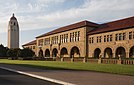    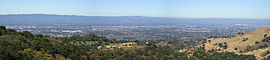 Clockwise: Downtown San Jose skyline; Hillsides in Morgan Hill; Alviso, San Jose; View of Santa Clara Valley; Almaden Reservoir in South San Jose; Stanford University. | |
 Santa Clara Valley Location in California | |
| Length | 30 miles (48 km) Northwest-Southeast |
| Geography | |
| Location | California, United States |
| Population centers | San Jose and several other cities of Silicon Valley |
| Borders on | San Francisco Bay (north), Santa Cruz Mountains (southwest), Diablo Range (northeast) |
| Coordinates | 37°22′01″N 121°59′02″W / 37.36694°N 121.98389°WCoordinates: 37°22′01″N 121°59′02″W / 37.36694°N 121.98389°W |

The Santa Clara Valley runs south-southeast from the southern end of San Francisco Bay in Northern California in the United States. The northern, urbanized end of the valley is part of a region locally known as the "South Bay" and also part of the electronics, research, and technology area known as Silicon Valley. Santa Clara Valley consists of most of Santa Clara County, including its county seat, San Jose, as well as a small portion of San Benito County. The valley, named after the Spanish Mission Santa Clara, was for a time known as the Valley of Heart's Delight for its high concentration of orchards, flowering trees, and plants.[1][2] Until the 1960s it was the largest fruit-producing and packing region in the world, with 39 canneries.[3][4]
Overview[]

Once primarily agricultural because of its highly fertile soil, Santa Clara Valley is now largely urbanized, although its far southern reaches south of Gilroy remain agrarian. The most northern urban areas are considered part of Silicon Valley. As Silicon Valley is not an actual valley, parts of the San Francisco Peninsula farther north are included in the Silicon Valley region as well. Locally, the urbanized areas of Santa Clara Valley are also referred to as part of the South Bay.
Few traces of its agricultural past can still be found, but the Santa Clara Valley American Viticultural Area remains a large wine-making region. It was one of the first commercial wine-producing regions in California (and possibly the United States), utilizing high-quality French varietal vines imported from France.[5][6]
The northern end of the Santa Clara Valley is at the southern tip of the San Francisco Bay, and the southern end is in the vicinity of Hollister. The valley is bounded by the Santa Cruz Mountains on the southwest, which separate the valley from the Pacific Ocean, and by the Diablo Range on the northeast. The valley is approximately 30 miles (50 km) long by 15 miles (20 km) wide. Its largest city, by an 86.7% margin, is San Jose. The population of the valley is 1.81 million people along with approximately 865,700 wage and salary jobs.[7] Santa Clara Valley has a Mediterranean semi-arid climate.
Joseph S. Diller, a geologist, observed in 1915 that a "notable peculiarity" of the Santa Clara Valley is that "it is divided transversely by a scarcely noticeable soil-covered divide."[8] The northern portion is drained northward by various rivers and creeks into San Francisco Bay. The southern portion of the valley is drained southward by Llagas Creek into the Pajaro River, which in turn flows westward to Monterey Bay. As one travels across the valley floor, "the alluvial plain is continuous across the divide."[8] The summit of the transverse divide is about two miles from the former town of Madrone at elevation 345 feet (105 meters), but the alluvial plain is so continuous that most travelers are unaware they are crossing between two drainage basins.[8]
History[]
The earliest inhabitants on the Santa Clara Valley are the Ohlone people, who had eight distinct languages and tribes in the coastal region.[9][10] Mission Santa Clara de Asís, which had control over a vast tract of land stretching from Palo Alto to Gilroy, was founded by Franciscans in 1777.[10] San Jose was California's first town and was also founded in 1777 by Spain as an agricultural pueblo.[10] There were 66 original settlers. In Spanish and Mexican times the land was devoted to cattle, as was most of California. Following the Mexican–American War San Jose was briefly the Capital of California. The influx of Americans (European Immigrants) resulted in relocation of many of the native Mexican and Indian people of San Jose to the mission at Santa Clara, which had been under control of Jesuits from 1850; they founded Santa Clara University there in 1851. In 1860, as an American town, the population of San Jose was 4,579, with cattle ranching still the main agricultural activity. For a time wheat became the main crop, but in the 1870s fruit gradually became the main crop and processing of fruit by drying or canning the predominant industry. The railroad reached San Jose in 1860.[11]
The Valley of Heart's Delight[]

The valley with its scenic beauty, mild climate, and thousands of acres of blooming fruit trees was known as "The Valley of Heart's Delight".[1][2] Various fruit cooperatives were formed in the area to deal with economic issues, including The California Fruit Union (founded in 1883) and the Santa Clara County Fruit Exchange (founded in 1892).[13][14] Prunes were a major crop, the valley was producing the majority of prunes in California by 1900 and they were shipped internationally.[15] Water was supplied from an artesian aquifer and when the water table dropped, wells were pumped. Many orchards were small with housing and fruit growing in a dispersed pattern. By the 1920s and 1930s, the agricultural and horticultural industries were doing well in the valley and included 18 canneries, 13 dried-fruit packing houses, and 12 fresh-fruit and vegetable shipping firms, and they were shipping internationally.[16] Del Monte and Sunsweet are two brands which originated in the Santa Clara Valley.
The need for workers greatly exceeded the local population and in the nineteenth century, Chinese and Japanese immigrants met that need. Toward the end of the nineteenth century many Italians and other immigrants from Southern and Eastern Europe came to the valley and worked in the orchards and canneries. During the 20th century there were Filipino immigrants and increasing numbers of immigrants from Mexico who during World War II became the dominant agricultural workforce. The town of San Jose was dominated by its business community, which was in part composed of Irish Catholics, who had a self-contained social life which did not include immigrant labor.[17] There was marked prejudice against Asians, particularly Chinese, who gradually left the valley.[18]
The Great Depression[]
Deflation and overproduction severely hurt the orchards and packers of the Santa Clara Valley during the Great Depression. Bankrupt farmers from the Dust Bowl, the Okies, made the trek to California. Desperate to feed their families they joined a workforce that was itself impacted by unemployment. The growers, with record low prices and surplus supply, could pay little. Labor organizers and goon squads battled in the labor camps.[19] Woody Guthrie's songs were on the radio and he wrote a regular column in the San Francisco-based The Daily People's World. San Francisco had a strong labor union tradition which extended to Santa Clara County. During the "March Inland" organizing drive the International Longshore and Warehouse Union (ILWU) backed the Cannery and Agricultural Workers' Industrial Union (CAWIU), a Communist-controlled union headquartered in San Jose, which had considerable success organizing farm and cannery workers in the Santa Clara Valley and elsewhere in California[19] until it was suppressed and its leaders jailed in 1934 by the State of California following sustained attacks by business, political and reactionary forces which, in San Jose, resulted in an atmosphere of terror (the low point of which was a public lynching tacitly supported by James Rolph, the Governor of California).[20] The canneries, with a segregated seasonal work force of white women, were eventually organized, at first by an AFL-affiliated company union, but one which gradually evolved, thanks to rank and file efforts, into a union which genuinely represented cannery workers.[21]
War and industry[]
The fruit industry gradually recovered and by the early 1940s prosperity returned to the valley. Wartime production associated with World War II brought industry to the valley such as building of marine engines for Liberty ships by the Joshua Hendy Iron Works, an historic mining and mill machinery manufacturer, now Northrop Grumman Marine Systems[22] in Sunnyvale, landing craft were built by Food Machinery Corporation (FMC later built the M113 (APC) Armored Personnel Carrier and the Bradley Fighting Vehicle as well as the XR311 at its facility in Santa Clara), and an IBM factory began manufacturing punch cards in San Jose in 1943. About 1,000 Japanese were interned, losing substantial property. Wartime production drew workers, including women, from the orchards and canneries; they were replaced by Mexican Americans from Texas and California and by Mexican braceros. Neighborhoods in East San Jose, such as the Meadowfair district, became barrios.
The Polaris missile was a Submarine Launched Ballistic Missile (SLBM) built during the Cold War by Lockheed Missiles & Space Division in Sunnyvale for the United States Navy while Northrop Grumman Marine Systems built the launch tubes and propulsion systems. For the most part the defense industries and traditional electronics manufacturers, with the exception of IBM, in the Santa Clara Valley were unionized, mainly by International Association of Machinists and Aerospace Workers, International Brotherhood of Electrical Workers, and Teamsters. The United Electrical, Radio and Machine Workers of America, a communist dominated union, but friendly to minority and women workers, gradually lost its place during the McCarthy era.[23]
In the 1950s the transistor industry was established which led, together with Xerox and Stanford University research and the Digital Revolution, to the Valley becoming Silicon Valley, a premier electronic technology center.[24]
Silicon Valley[]
Silicon Valley is traditionally known as the entirety of Santa Clara County, as well as southern San Mateo County and southern Alameda county, however the boundaries of the Silicon Valley region have expanded over the years.[25] In the 1970s, this region had a clustering of semiconductor companies, which is how it got its name.[25]
San Jose[]
In 1950 Dutch Hamann was appointed city manager of San Jose. Hamann's boosterism was supported by Joe Ridder, publisher of the San Jose Mercury. In power until 1969, Hamann created a master plan for San Jose and embarked on a program of annexation that increased the area of San Jose from 17 square miles to 136.7 square miles. The main bargaining chip was the superior sewage system built to handle cannery waste. To overcome resistance by school districts, who otherwise would have lost their tax base, annexed areas were allowed to maintain independent school districts. This resulted in some parts of the city such as East San Jose having low-quality segregated school systems with a low tax base while school systems in other parts of San Jose have an ample tax base and high-quality schools. The population of San Jose increased from 95 thousand in 1950 to 446 thousand in 1970. There were critics: Santa Clara County Planning Director Karl Belser, who opposed urban sprawl, commented. "Perhaps the only use we will ever find for the hydrogen bomb will be to erase this great mistake from the face of the earth." Housing for each additional 1000 people took 257 acres of land.[26]
Schools[]
Funding for public schools in upscale communities in the Santa Clara Valley is often supplemented by grants from private foundations set up for that purpose and funded by local residents. Schools in less favorable demographics must depend on state funding.[27]
Cities and towns[]

Cities and towns in the Santa Clara Valley include (in alphabetical order):[citation needed]
- Campbell
- Cupertino
- Gilroy
- Hollister
- Los Gatos
- Los Altos
- Los Altos Hills
- Milpitas
- Monte Sereno
- Morgan Hill
- Mountain View
- Palo Alto
- San Martin
- San Jose
- San Juan Bautista
- Santa Clara
- Saratoga
- Sunnyvale
Because so much high-tech industry has spread out from the Silicon Valley, Fremont and Newark, even though they are not in Santa Clara County, are often included in discussions about the Silicon Valley or, in the case of Fremont, referred to as the Gateway to the Silicon Valley (a title also claimed occasionally by San Jose, Union City, and several other locations). Similarly, Palo Alto, while in Santa Clara County and considered part of Silicon Valley, is on the San Francisco Peninsula.


San Francisco South Bay[]
The South Bay is a subregion of the San Francisco Bay Area, California and is roughly synonymous with the Santa Clara Valley, Silicon Valley, and Santa Clara County (in general).[citation needed] The South Bay is one of several subregions in the Bay Area including: San Francisco, the North Bay including parts of the Wine Country, the Peninsula, and the East Bay, among others.
Many other cities, towns or census-designated places are also sometimes considered part of the region, such as the San Lorenzo Valley towns between Saratoga and Santa Cruz.[citation needed]
Some cities in the East Bay or especially on the Peninsula sometimes are referred to as part of the region. Many of these cities including Menlo Park, Redwood City, Newark, and Fremont are considered part of the Silicon Valley (and therefore the South Bay) because of their relative peripheral location to Santa Clara County, history, or concentration of high-tech companies. The conception of the South Bay as a region is relatively new compared to that of the Peninsula and coastal East Bay.
Notable structures[]
This section is in list format, but may read better as prose. (April 2018) |

There are a number of well-known structures and sites of interest in the South Bay:
- Apple Park, Cupertino
- Hewlett Packard, Palo Alto
- Stanford University, Palo Alto
- SAP Center, downtown San José
- Hayes Mansion, Southern San José
- Plaza de César Chávez, downtown San José
- Cathedral Basilica of Saint Joseph, downtown San Jose
- Winchester Mystery House, Western San José
- Santana Row, Western San José
- Lick Observatory, Mount Hamilton
- Rosicrucian Egyptian Museum, Central San José
- Mexican Heritage Plaza, Eastern San Jose
- History Park at Kelley Park, Central San José
- Children's Discovery Museum of San Jose, Downtown San José
- San Jose International Airport, uptown San José
- San Jose Museum of Art, downtown San José
- San Jose State University, downtown San José
- Santa Clara University, Santa Clara (which includes the original Santa Clara Mission site)
- California's Great America, Santa Clara
- The Tech Museum of Innovation, downtown San José
- Moffett Federal Airfield, Sunnyvale/Mountain View
- Yahoo!, Sunnyvale
- LinkedIn, Sunnyvale
- Alviso, Northern San José (sea access/ main port of goods from Asia in 1800 before Oakland took over the following century)
- Berryessa Flea Market, Northern San José (previously Earth's largest)
- Gurdwara Sahib of San Jose, Eastern San José (Sikh Temple built by President Jit Singh Bainiwal)
Geology[]
Santa Clara Valley was created by the sudden growth of the Santa Cruz Mountains and the Diablo Range during the later Cenozoic era. This was a period of intense mountain building in California when the folding and thrusting of the Earth's crust, combined with active volcanism, gave shape to the present state of California. Hence, Santa Clara Valley is a structural valley, created by mountain building as opposed to an erosional valley, which is a valley that has undergone the wearing away of the Earth's surface by natural agents. The underlying geology of the Santa Cruz Mountains was also formed by the sediment of the ancient seas, where marine shale points to Miocene origin. Today one can still find evidence of this in the Santa Cruz Mountains, where shark's teeth and the remains of maritime life are still found as high as Scotts Valley, a city nestled in the mountains.[28] The highest peak on the Santa Cruz Mountains side of the valley is Loma Prieta at 3,790 feet. The highest peak in the Diablo Range side of the valley is Mount Hamilton, specifically Copernicus Peak at 4,370 feet elevation. It is the highest peak in Santa Clara County.
The valley is a graben between the San Andreas and Hayward faults.[29]
Quicksilver mine[]
During the 19th century, 37,388 metric tons of mercury were extracted from the New Almaden mine south of San Jose and northwest of Santa Cruz. The area, closed for many years, resulted in pollution of the Guadalupe River and South San Francisco Bay.[30] After intermittent mining operations finally ceased in the 20th century, the area was purchased by Santa Clara County to be used as a park and was designated a National Historic Landmark.[31]
Climate[]

The climate of the Santa Clara Valley in California is a Mediterranean climate[32] with warm, very dry summers and mild, fairly rainy winters. Today, the Valley attracts many people from the East Coast with its warm and sunny climate. The Santa Clara Valley receives on average 330 sunny days per year. The northern areas of the valley (such as Palo Alto or Mountain View) have greater marine influences with temperatures rarely rising above 85 °F (29 °C) while in the southern areas and near the mountains (such as Los Gatos, Morgan Hill, or Gilroy) the temperature frequently exceeds 95 °F (35 °C) in the summer months. Winter is the rainy season, but still quite sunny. Winter highs range from 57 °F (14 °C) to 66 °F (19 °C)[33] while lows range from 40 °F (4 °C) to 48 °F (9 °C). Summer highs range from 82 °F (28 °C) to 95 °F (35 °C) and summer lows range from 53 °F (12 °C) to 58 °F (14 °C).
The record high for the Santa Clara Valley was recorded in Los Gatos on June 9, 2000, with a temperature of 114 °F (46 °C) and the record low was recorded in Gilroy on December 23, 1990, with a temperature of 16 °F (−9 °C).[34] Temperatures drop below 40 °F (4 °C) on average of 17 days per year, below freezing on average of 4 days per year and below 30 °F (−1 °C) on average of 0 days per year (none).
Temperatures[]
| hideClimate data for San Jose, California | |||||||||||||
|---|---|---|---|---|---|---|---|---|---|---|---|---|---|
| Month | Jan | Feb | Mar | Apr | May | Jun | Jul | Aug | Sep | Oct | Nov | Dec | Year |
| Record high °F (°C) | 83 (28) |
85 (29) |
87 (31) |
95 (35) |
101 (38) |
109 (43) |
108 (42) |
105 (41) |
104 (40) |
101 (38) |
85 (29) |
83 (28) |
109 (43) |
| Average high °F (°C) | 62 (17) |
65 (18) |
70 (21) |
73 (23) |
77 (25) |
82 (28) |
84 (29) |
84 (29) |
81 (27) |
76 (24) |
65 (18) |
62 (17) |
72.9 (22.7) |
| Average low °F (°C) | 43 (6) |
45 (7) |
46 (8) |
48 (9) |
52 (11) |
55 (13) |
57 (14) |
57 (14) |
56 (13) |
52 (11) |
45 (7) |
43 (6) |
49.8 (9.9) |
| Record low °F (°C) | 24 (−4) |
26 (−3) |
30 (−1) |
35 (2) |
37 (3) |
42 (6) |
47 (8) |
47 (8) |
42 (6) |
36 (2) |
21 (−6) |
20 (−7) |
20 (−7) |
| Average precipitation inches (mm) | 3.2 (81) |
2.8 (71) |
2.6 (66) |
1.0 (25) |
0.4 (10) |
0.1 (2.5) |
0.1 (2.5) |
0.1 (2.5) |
0.2 (5.1) |
0.9 (23) |
1.2 (30) |
2.0 (51) |
15.1 (380) |
| Source: AccuWeather.com[35] | |||||||||||||
.
| hideClimate data for Campbell, California | |||||||||||||
|---|---|---|---|---|---|---|---|---|---|---|---|---|---|
| Month | Jan | Feb | Mar | Apr | May | Jun | Jul | Aug | Sep | Oct | Nov | Dec | Year |
| Record high °F (°C) | 83 (28) |
86 (30) |
89 (32) |
93 (34) |
98 (37) |
110 (43) |
108 (42) |
106 (41) |
106 (41) |
100 (38) |
86 (30) |
83 (28) |
110 (43) |
| Average high °F (°C) | 63 (17) |
66 (19) |
71 (22) |
75 (24) |
79 (26) |
82 (28) |
85 (29) |
85 (29) |
82 (28) |
76 (24) |
66 (19) |
63 (17) |
74 (23) |
| Average low °F (°C) | 43 (6) |
46 (8) |
47 (8) |
49 (9) |
52 (11) |
56 (13) |
57 (14) |
57 (14) |
55 (13) |
51 (11) |
46 (8) |
43 (6) |
50 (10) |
| Record low °F (°C) | 22 (−6) |
26 (−3) |
29 (−2) |
35 (2) |
38 (3) |
42 (6) |
42 (6) |
40 (4) |
38 (3) |
36 (2) |
29 (−2) |
19 (−7) |
19 (−7) |
| Average precipitation inches (mm) | 4.7 (120) |
4.1 (100) |
2.6 (66) |
0.6 (15) |
0.3 (7.6) |
0.1 (2.5) |
0.1 (2.5) |
0.1 (2.5) |
0.3 (7.6) |
0.7 (18) |
2.5 (64) |
4.3 (110) |
21.6 (550) |
| [citation needed] | |||||||||||||
| hideClimate data for Los Gatos, California | |||||||||||||
|---|---|---|---|---|---|---|---|---|---|---|---|---|---|
| Month | Jan | Feb | Mar | Apr | May | Jun | Jul | Aug | Sep | Oct | Nov | Dec | Year |
| Record high °F (°C) | 83 (28) |
86 (30) |
89 (32) |
96 (36) |
101 (38) |
114 (46) |
113 (45) |
107 (42) |
109 (43) |
103 (39) |
87 (31) |
83 (28) |
114 (46) |
| Average high °F (°C) | 63 (17) |
66 (19) |
72 (22) |
76 (24) |
80 (27) |
84 (29) |
86 (30) |
86 (30) |
84 (29) |
77 (25) |
66 (19) |
63 (17) |
75 (24) |
| Average low °F (°C) | 43 (6) |
46 (8) |
47 (8) |
49 (9) |
52 (11) |
56 (13) |
57 (14) |
57 (14) |
55 (13) |
51 (11) |
46 (8) |
43 (6) |
50 (10) |
| Record low °F (°C) | 22 (−6) |
25 (−4) |
28 (−2) |
35 (2) |
37 (3) |
41 (5) |
41 (5) |
40 (4) |
38 (3) |
36 (2) |
28 (−2) |
19 (−7) |
19 (−7) |
| Average precipitation inches (mm) | 4.9 (120) |
4.1 (100) |
2.8 (71) |
0.6 (15) |
0.3 (7.6) |
0.1 (2.5) |
0.1 (2.5) |
0.1 (2.5) |
0.3 (7.6) |
0.7 (18) |
2.8 (71) |
4.8 (120) |
22.8 (580) |
| [citation needed] | |||||||||||||
| hideClimate data for Sunnyvale, California | |||||||||||||
|---|---|---|---|---|---|---|---|---|---|---|---|---|---|
| Month | Jan | Feb | Mar | Apr | May | Jun | Jul | Aug | Sep | Oct | Nov | Dec | Year |
| Record high °F (°C) | 75 (24) |
84 (29) |
85 (29) |
94 (34) |
100 (38) |
107 (42) |
105 (41) |
101 (38) |
105 (41) |
100 (38) |
89 (32) |
75 (24) |
107 (42) |
| Average high °F (°C) | 61 (16) |
62 (17) |
64 (18) |
69 (21) |
73 (23) |
77 (25) |
79 (26) |
79 (26) |
78 (26) |
73 (23) |
64 (18) |
61 (16) |
70 (21) |
| Average low °F (°C) | 42 (6) |
43 (6) |
46 (8) |
47 (8) |
51 (11) |
55 (13) |
57 (14) |
57 (14) |
55 (13) |
50 (10) |
44 (7) |
42 (6) |
49 (10) |
| Record low °F (°C) | 21 (−6) |
24 (−4) |
22 (−6) |
31 (−1) |
33 (1) |
40 (4) |
41 (5) |
44 (7) |
41 (5) |
34 (1) |
15 (−9) |
20 (−7) |
15 (−9) |
| Average precipitation inches (mm) | 3.24 (82) |
3.18 (81) |
2.65 (67) |
0.89 (23) |
0.35 (8.9) |
0.11 (2.8) |
0.03 (0.76) |
0.08 (2.0) |
0.19 (4.8) |
0.85 (22) |
1.83 (46) |
2.31 (59) |
15.71 (399.26) |
| Source: National Weather Service[36] | |||||||||||||
| hideClimate data for Mountain View, California | |||||||||||||
|---|---|---|---|---|---|---|---|---|---|---|---|---|---|
| Month | Jan | Feb | Mar | Apr | May | Jun | Jul | Aug | Sep | Oct | Nov | Dec | Year |
| Average high °F (°C) | 59 (15) |
63 (17) |
64 (18) |
70 (21) |
73 (23) |
77 (25) |
79 (26) |
79 (26) |
79 (26) |
73 (23) |
64 (18) |
59 (15) |
70 (21) |
| Average low °F (°C) | 41 (5) |
43 (6) |
46 (8) |
46 (8) |
52 (11) |
52 (11) |
52 (11) |
52 (11) |
52 (11) |
48 (9) |
45 (7) |
41 (5) |
48 (9) |
| Average precipitation inches (mm) | 3.24 (82.3) |
3.18 (80.8) |
2.65 (67.3) |
0.89 (22.6) |
0.35 (8.9) |
0.11 (2.8) |
0.03 (0.8) |
0.08 (2.0) |
0.19 (4.8) |
0.85 (21.6) |
1.83 (46.5) |
2.31 (58.7) |
15.71 (399.1) |
| Source: http://www.weather.com/outlook/travel/businesstraveler/wxclimatology/monthly/graph/94043?from=text_bottomnav_business#climograph | |||||||||||||
See also[]
 San Francisco Bay Area portal
References[]
- ^ Jump up to: a b Matthews, Glenna (2003). Silicon Valley, Women, and the California Dream: Gender, Class, and Opportunity in the Twentieth Century. Stanford: Stanford University Press. p. 2. ISBN 9780804741545.
- ^ Jump up to: a b Shueh, Sam (2009). Silicon Valley. Charleston, SC: Arcadia Publishing. p. 8. ISBN 9780738570938. Retrieved 28 July 2020.
- ^ Valley of Heart's Delight : Free Download & Streaming : Internet Archive. Archive.org (2001-03-10). Retrieved on 2013-07-21.
- ^ Golden Harvest...Fifty Years of Calpak Progress : California Packing Corporation, Industrial and Public Relations Department : Free Download & Streaming : Internet Archive. Archive.org. Retrieved on 2013-07-21.
- ^ Santa Clara. Ohp.parks.ca.gov. Retrieved on 2013-07-21.
- ^ Almaden Winery History from NCD. Awna.org (1997-01-23). Retrieved on 2013-07-21.
- ^ "Archived copy" (PDF). Archived from the original (PDF) on 2014-08-20. Retrieved 2013-10-21.CS1 maint: archived copy as title (link)
- ^ Jump up to: a b c Diller, J.S. (1915). Guidebook of the Western United States — Part D: The Shasta Route and Coast Line. Washington, D.C.: Government Printing Office. pp. 124–125.
- ^ "Pre-History". San Jose History. 2013-11-04. Retrieved 2018-04-10.
- ^ Jump up to: a b c "Early History Essay -- Santa Clara County, California". National Register of Historic Places Travel Itinerary. Retrieved 2018-04-10.
- ^ Glenda Matthews (November 20, 2002). Silicon Valley, Women, and the California Dream: Gender, Class, and Opportunity in the Twentieth Century (trade paperback) (1 ed.). Stanford, California: Stanford University Press. p. 14. ISBN 978-0804747967. Retrieved January 16, 2015.
- ^ "Heritage Resources and Landmark Alteration Inventory" (PDF). City of Sunnyvale Heritage Preservation Commission. Retrieved 2012-10-07.
- ^ "The Santa Clara Fruit Exchange". California Digital Newspaper Collection. Pacific Rural Press, Volume 44, Number 3. 1892-07-16. Retrieved 2018-04-10.
- ^ Proceedings, State Fruit Growers Convention. San Jose, California: State Board of Agriculture. 1900. p. 33 – via Google Books.
- ^ Arbuckle, Clyde (1985). Clyde Arbuckle's History of San Jose. Smith & McKay Printing Company. p. 160.
- ^ "Looking Back: Canning in the Valley of Heart's Delight". San Jose Public Library. 2013-05-23. Retrieved 2018-04-10.
- ^ Mary Bowden Carroll (1988). Ten Years in Paradise: Leaves from a Society Reporter's Note-Book (Reprint ed.). San Jose, California: San Jose Historical Museum Association. pp. entire book.
Originally published in 1903
- ^ Glenda Matthews (November 20, 2002). Silicon Valley, Women, and the California Dream: Gender, Class, and Opportunity in the Twentieth Century (trade paperback) (1 ed.). Stanford, California: Stanford University Press. pp. 14–32. ISBN 978-0804747967. Retrieved January 16, 2015.
- ^ Jump up to: a b Kate Bronfenbrenner, "California Farmworkers' Strikes of 1933", pages 79-83 in Labor conflict in the United States: An encyclopedia, edited by R. L. Filippelli, Garland Publishing, Inc. (1990) ISBN 082407968X
- ^ Glenda Matthews (November 20, 2002). Silicon Valley, Women, and the California Dream: Gender, Class, and Opportunity in the Twentieth Century (trade paperback) (1 ed.). Stanford, California: Stanford University Press. pp. 53–64. ISBN 978-0804747967. Retrieved January 16, 2015.
- ^ Glenda Matthews (November 20, 2002). Silicon Valley, Women, and the California Dream: Gender, Class, and Opportunity in the Twentieth Century (trade paperback) (1 ed.). Stanford, California: Stanford University Press. pp. 48–80. ISBN 978-0804747967. Retrieved January 16, 2015.
- ^ "Northrop Grumman Marine Systems Celebrates 100 Years in Operation in Sunnyvale, California". Irconnect.com. Retrieved 7 November 2017.
- ^ Glenda Matthews (November 20, 2002). Silicon Valley, Women, and the California Dream: Gender, Class, and Opportunity in the Twentieth Century (trade paperback) (1 ed.). Stanford, California: Stanford University Press. pp. 119–22. ISBN 978-0804747967. Retrieved January 16, 2015.
- ^ Glenda Matthews (November 20, 2002). Silicon Valley, Women, and the California Dream: Gender, Class, and Opportunity in the Twentieth Century (trade paperback) (1 ed.). Stanford, California: Stanford University Press. pp. 81–146. ISBN 978-0804747967. Retrieved January 16, 2015.
- ^ Jump up to: a b O'Brien, Shaun (2012-04-19). "Welcome to the new and expanded Silicon Valley". The Mercury News. Retrieved 2018-04-10.
- ^ Glenda Matthews (November 20, 2002). Silicon Valley, Women, and the California Dream: Gender, Class, and Opportunity in the Twentieth Century (trade paperback) (1 ed.). Stanford, California: Stanford University Press. pp. 95–102. ISBN 978-0804747967. Retrieved January 16, 2015.
- ^ George Packer (May 27, 2013). "Change the World Silicon Valley transfers its slogans—and its money—to the realm of politics". The New Yorker. Retrieved July 30, 2015.
In wealthy districts, the public schools have essentially been privatized; they insulate themselves from shortfalls in state funding with money raised by foundations they have set up for themselves.
- ^ "Early History". Santa Clara County: California's Historic Silicon Valley. National Park Service. Retrieved 2008-01-18.
- ^ "Timeline of the history of water in Santa Clara County - Santa Clara Valley Water District". Valleywater.org. Retrieved 7 November 2017.
- ^ "New Almaden Mine CERCLA Site". California Department of Fish and Wildlife. Retrieved June 17, 2016.
LOCATION: Guadalupe River and South San Francisco Bay, Santa Clara County
- ^ "New Almaden Quicksilver County Park Association Homepage". Newalmaden.org. Retrieved 7 November 2017.
- ^ [1]
- ^ "Google Image Result". Images.google.com. Retrieved 7 November 2017.
- ^ [2]
- ^ "San Jose, CA Typical Weather". Accuweather. Retrieved 2 March 2009.
- ^ "Vacation Planner". Weather Channel. Retrieved 2009-05-22.
Further reading[]
- Yvonne Jacobson, Passing Farms, Enduring Values: California's Santa Clara Valley
- Robin Chapman, California Apricots: The Lost Orchards of Silicon Valley
External links[]
- History San José collects, preserves and celebrates the stories of diversity and innovation in San José and the Santa Clara Valley
- Up-to-the-minute view of San Jose from the Mount Hamilton web camera
| show San Francisco Bay Area |
|---|


| show Authority control |
|---|
- Valleys of San Benito County, California
- Valleys of Santa Clara County, California
- Silicon Valley
- Subregions of the San Francisco Bay Area
- California wine
- Valleys of California