Sehore district
Sehore District | |
|---|---|
District of Madhya Pradesh | |
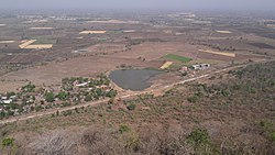 View from Salkanpur Hill | |
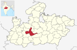 Location of Sehore district in Madhya Pradesh | |
| Coordinates (Sehore): 23.2032° N, 77.0844° E | |
| Country | |
| State | Madhya Pradesh |
| Division | Bhopal |
| Headquarters | Sehore |
| Tehsils | 8: Sehore, Ashta, Budni, Nasrullaganj, Rehti, Ichhawar, Shyampur, Jawar |
| Government | |
| • Lok Sabha constituencies | Bhopal |
| Area | |
| • Total | 6,578 km2 (2,540 sq mi) |
| Population (2011) | |
| • Total | 1,311,332 |
| • Density | 200/km2 (520/sq mi) |
| Demographics | |
| • Literacy | 70.06% |
| • Sex ratio | 918 |
| Time zone | UTC+05:30 (IST) |
| Major highways | Bhopal-Indore Highway |
| Website | sehore |
Sehore District is a district of Madhya Pradesh state in central India. The town of Sehore is the district headquarters. The district is part of Bhopal Division.
Demographics[]
According to the 2011 census, Sehore District has a population of 1,311,332.[1][2][3] This gives it a ranking of 373 in India (out of a total of 640).[1] The district has a population density of 199 inhabitants per square kilometre (520/sq mi).[1] Its population growth rate over the decade 2001-2011 was 21.51%.[1] Sehore has a sex ratio of 918 females for every 1,000 males[1] and a literacy rate of 71.11%.[1]
According to the 2011 Census of India, 97.22% of the population in the district spoke Hindi and 2.31% Urdu as their first language.[4]
| Year | Pop. | ±% p.a. |
|---|---|---|
| 1901 | 234,308 | — |
| 1911 | 254,693 | +0.84% |
| 1921 | 242,362 | −0.50% |
| 1931 | 262,560 | +0.80% |
| 1941 | 278,270 | +0.58% |
| 1951 | 283,968 | +0.20% |
| 1961 | 381,286 | +2.99% |
| 1971 | 510,894 | +2.97% |
| 1981 | 657,381 | +2.55% |
| 1991 | 841,358 | +2.50% |
| 2001 | 1,078,912 | +2.52% |
| 2011 | 1,311,332 | +1.97% |
| source:[5] | ||
References[]
- ^ Jump up to: a b c d e f "District Census 2011". Census2011.co.in. 2011. Retrieved 30 September 2011.
- ^ US Directorate of Intelligence. "Country Comparison:Population". Retrieved 1 October 2011.
Mauritius 1,303,717 July 2011 est.
- ^ "2010 Resident Population Data". U. S. Census Bureau. Retrieved 30 September 2011.
New Hampshire 1,316,470
- ^ 2011 Census of India, Population By Mother Tongue
- ^ Decadal Variation In Population Since 1901
External links[]
| show Places adjacent to Sehore district |
|---|
| show |
|---|
Coordinates: 23°12′N 77°05′E / 23.200°N 77.083°E

This article related to a location in Madhya Pradesh is a stub. You can help Wikipedia by . |
- Sehore district
- Districts of Madhya Pradesh
- Madhya Pradesh geography stubs