Serangoon
This article needs additional citations for verification. (April 2012) |
Serangoon | |
|---|---|
| Other transcription(s) | |
| • Chinese | 实龙岗 |
| • Pinyin | Shí lónggǎng |
| • Malay | Serangoon |
| • Tamil | சிராங்கூன் |
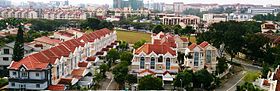 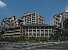 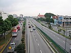 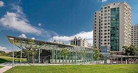  From top left to right: Terraced housing in Serangoon, HDB flats in Serangoon North, Serangoon Viaduct, Lorong Chuan MRT station, Nex | |
 Serangoon Location of Serangoon within Singapore | |
| Coordinates: 1°21′19.28″N 103°52′4.33″E / 1.3553556°N 103.8678694°E | |
| Country | |
| Region | North-East Region
|
| CDCs | |
| Town councils |
|
| Constituencies | |
| Government | |
| • Mayors | Central Singapore CDC
North East CDC South East CDC |
| • Members of Parliament | Aljunied GRC
Ang Mo Kio GRC Marine Parade GRC Hougang SMC
|
| Area | |
| • Total | 10.1 km2 (3.9 sq mi) |
| • Residential | 1.63 km2 (0.63 sq mi) |
| Population | |
| • Total | 116,310 |
| • Density | 12,000/km2 (30,000/sq mi) |
| Postal districts | 19, 28 |
| Dwelling units | 21,293 |
| Projected ultimate | 30,000 |

Serangoon (/səræŋɡuːn/) is a planning area and residential town located in the North-East Region of Singapore.
Serangoon is bordered by these planning areas – Sengkang to the north, Hougang to the east, Ang Mo Kio and Bishan to the west, as well as Toa Payoh to the south. Serangoon planning area has a total of seven subzones: Serangoon Central, Lorong Chuan, Upper Paya Lebar, Serangoon Garden, Serangoon North, Seletar Hills and Serangoon North Industrial Estate.[4]
Transportation[]
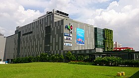
The original Serangoon bus interchange was opened on 13 March 1988 along Serangoon Central.[5] It later relocated to nex on 3 September 2011.[6]
A large part of the North East MRT line runs in parallel with this arterial road. Stations that are located along this road are from Little India to Kovan.
Education[]
As of 2017, this area has a total of 5 primary schools, 4 secondary schools and Nanyang Junior College.[7]
Politics[]
Serangoon Neighbourhood 1, some parts of Neighbourhood 2 and Serangoon Garden fall under the Aljunied GRC (Serangoon division), served by the Workers' Party, while the area surrounding Upper Paya Lebar Road lies within the Aljunied GRC Paya Lebar division. Prior to 2006, the Serangoon division belonged to the Marine Parade GRC, which administers Serangoon Neighbourhoods 2, 3 and 4 in the Braddell Heights division till this day. Neighbourhood 5 in Serangoon North falls under the Ang Mo Kio GRC (Jalan Kayu division).
See also[]
Gallery[]

References[]
- ^ Jump up to: a b City Population – statistics, maps and charts | Serangoon
- ^ Jump up to: a b HDB Key Statistics FY 2014/2015 Archived 4 March 2016 at the Wayback Machine
- ^ "Statistics Singapore - Geographic Distribution - 2018 Latest Data". Retrieved 11 February 2019.
- ^ "Archived copy" (PDF). Archived from the original (PDF) on 5 March 2016. Retrieved 24 October 2015.CS1 maint: archived copy as title (link)
- ^ "Interchange in new town opens on Sunday". The Straits Times. 8 March 1988. Retrieved 23 June 2017 – via NewspaperSG.
- ^ "Bus Services Operating From The New Serangoon Bus Interchange". SBS Transit. 25 August 2017. Retrieved 23 June 2017.
- ^ School Information Service
Sources[]
- Victor R Savage, Brenda S A Yeoh (2003), Toponymics – A Study of Singapore Street Names, Eastern Universities Press, ISBN 981-210-205-1
External links[]
- Serangoon
- Places in Singapore