Sherridon
Sherridon | |
|---|---|
 Community boundaries | |
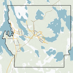
 Sherridon Location of Sherridon | |
| Coordinates: 55°7′26″N 101°5′12″W / 55.12389°N 101.08667°WCoordinates: 55°7′26″N 101°5′12″W / 55.12389°N 101.08667°W | |
| Country | Canada |
| Province | Manitoba |
| Region | Northern |
| Census Division | No. 21 |
| Government | |
| • Mayor | Nick Benyk |
| • Governing Body | Sherridon Community Council |
| • MP | Niki Ashton |
| • MLA | Tom Lindsey |
| Population | |
| • Total | 80 |
| • Density | 4.1/km2 (11/sq mi) |
| Time zone | UTC−06:00 (CST) |
| • Summer (DST) | UTC−05:00 (CDT) |
| Postal Code | R0B 1L0 |
| Area code(s) | 204, 431 |
| NTS Map | 063N03 |
| GNBC Code | GAZAC |

Sherridon, Manitoba is an unincorporated community in Manitoba, Canada.
Sherridon originated as the service centre for the nearby Sherritt Gordon nickel mines. The mine closed in 1952, resulting in the equipment and many of the workers and families relocating to Lynn Lake. In 1949 the first house from Sherridon was sleighed to Lynn Lake as a test run over the 160 mi (260 km) of cat train trails. Over the next three years, 208 buildings were moved to Lynn Lake from Sherridon. Houses, stores, banks and churches were loaded on sleighs and pulled by caterpillar tractors over the ice and snow to Lynn Lake.
The historic four-storey Hotel Cambrian, one of the only early 20th century buildings in the community not moved to Lynn Lake, was destroyed by fire on June 2, 2012. At the time of the fire the hotel was unoccupied, in a state of disrepair, and had been disconnected from electricity. The Royal Canadian Mounted Police consider the fire suspicious.[2]
A recent gold mine, operated by Pioneer Metals at Puffy Lake, closed in 1989. The community is located on the OmniTRAX rail line to Lynn Lake about 156 km (97 mi) north of The Pas. Pukatawagan Reserve is 72 km (45 mi) further north of Sherridon. A 78 km (48 mi) community-access gravelled road was constructed as part of the Puffy Lake Mine development, and the community is now connected to Provincial Trunk Highway 10 (PTH 10) between Cranberry Portage and Flin Flon.
In 2011 Sherridon had a population of 80.
References[]
- ^ "Census Profile - Data table: Sherridon, NCM (Designated Place), Manitoba". Statistics Canada, 2011 Census of Population. 2012-09-07. Retrieved 2012-10-20.
- ^ "Sherridon historic hotel fire under investigation". CBC News - Manitoba. 2012-06-03. Retrieved 2012-10-20.
| show Authority control |
|---|
- Designated places in Manitoba
- Northern communities in Manitoba