Signy-le-Petit
show This article may be expanded with text translated from the corresponding article in French. (December 2008) Click [show] for important translation instructions. |
Signy-le-Petit | |
|---|---|
Commune | |
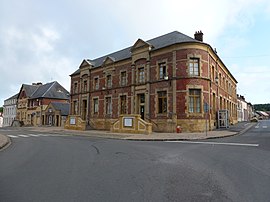 The town hall in Signy-le-Petit | |
 Coat of arms | |
show Location of Signy-le-Petit | |
 Signy-le-Petit | |
| Coordinates: 49°54′16″N 4°16′50″E / 49.9044°N 4.2806°ECoordinates: 49°54′16″N 4°16′50″E / 49.9044°N 4.2806°E | |
| Country | France |
| Region | Grand Est |
| Department | Ardennes |
| Arrondissement | Charleville-Mézières |
| Canton | Rocroi |
| Government | |
| • Mayor (2020–2026) | Béatrice Cardon |
| Area 1 | 38.72 km2 (14.95 sq mi) |
| Population (Jan. 2018)[1] | 1,218 |
| • Density | 31/km2 (81/sq mi) |
| Time zone | UTC+01:00 (CET) |
| • Summer (DST) | UTC+02:00 (CEST) |
| INSEE/Postal code | 08420 /08380 |
| 1 French Land Register data, which excludes lakes, ponds, glaciers > 1 km2 (0.386 sq mi or 247 acres) and river estuaries. | |


Signy-le-Petit (French pronunciation: [siɲi lə pəti]) is a commune in the Ardennes department in northern France.
Population[]
| Year | Pop. | ±% |
|---|---|---|
| 1962 | 1,463 | — |
| 1968 | 1,592 | +8.8% |
| 1975 | 1,543 | −3.1% |
| 1982 | 1,361 | −11.8% |
| 1990 | 1,280 | −6.0% |
| 1999 | 1,314 | +2.7% |
| 2008 | 1,299 | −1.1% |
See also[]
References[]
- ^ "Populations légales 2018". INSEE. 28 December 2020.
| Wikimedia Commons has media related to Signy-le-Petit. |
| show Authority control |
|---|
This Ardennes geographical article is a stub. You can help Wikipedia by . |
Categories:
- Communes of Ardennes (department)
- Ardennes (department) geography stubs