Smoky Lake
Smoky Lake | |
|---|---|
Town | |
| Town of Smoky Lake | |
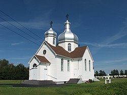 Holy Trinity Orthodox Church | |
| Motto(s): Pumpkin Capital of Alberta[1] | |
 Smoky Lake Location of Smoky Lake in Alberta | |
| Coordinates: 54°07′15″N 112°28′24″W / 54.12083°N 112.47333°WCoordinates: 54°07′15″N 112°28′24″W / 54.12083°N 112.47333°W | |
| Country | Canada |
| Province | Alberta |
| Region | Central Alberta |
| Census division | 12 |
| Municipal district | Smoky Lake County |
| Incorporated[3] | |
| • Village | March 26, 1923 |
| • Town | February 1, 1962 |
| Government | |
| • Mayor | Hank Holowaychuk |
| • Governing body | show
Smoky Lake Town Council |
| • MP | Shannon Stubbs |
| • MLA | Glenn van Dijken |
| Area (2016)[4] | |
| • Land | 4.26 km2 (1.64 sq mi) |
| Elevation | 623 m (2,044 ft) |
| Population (2016)[4] | |
| • Total | 964 |
| • Density | 226.2/km2 (586/sq mi) |
| Time zone | UTC−07:00 (MST) |
| • Summer (DST) | UTC−06:00 (MDT) |
| Highways | Highway 28 Highway 855 |
| Waterway | North Saskatchewan River Smoky Lake |
| Website | Official website |


Smoky Lake is a town in central Alberta, Canada. It is located 116 km (72 mi) northeast of Edmonton at the junction of Highway 28 and Highway 855. It lies between the North Saskatchewan River, Smoky Creek and White Earth Creek, in a mainly agricultural area. The provincial historic site of Victoria Settlement is nearby. Long Lake Provincial Park is located 60 km (37 mi) north of the town. The Woods Cree, a First Nations people, named "Smoking Lake" for the smoke from ceremonies performed on the shore; the name Smoky Lake may also be based in the mist that rose from the lake in great quantities at sundown.[6] One of its churches, the St. Onuphrius Ukrainian-Catholic, built in 1907, has been moved to the Canadian Museum of History in Gatineau, Quebec.[7] It is in Census Division No. 12 and is the municipal office for the Smoky Lake County.
Demographics[]
In the 2016 Census of Population conducted by Statistics Canada, the Town of Smoky Lake recorded a population of 964 living in 421 of its 499 total private dwellings, a -5.7% change from its 2011 population of 1,022. With a land area of 4.26 km2 (1.64 sq mi), it had a population density of 226.3/km2 (586.1/sq mi) in 2016.[4]
In the 2011 Census, the Town of Smoky Lake had a population of 1,022 (living in 430 of its 478 total dwellings), a 1.2% change from its 2006 population of 1,010. With a land area of 4.2 km2 (1.6 sq mi), it had a population density of 243.3/km2 (630.2/sq mi) in 2011.[8]
Notable people[]
- Mary Burzminski, track and field athlete
- Eddie Carroll, Actor, voice over
- John Dubetz, Alberta legislator
- Terry Ewasiuk, professional ice hockey player
- Isidore Goresky, Alberta legislator
- Ray Kinasewich, professional ice hockey player
- Steve Zarusky, Alberta legislator
See also[]
References[]
- ^ "Town of Smoky Lake". Kalyna Country. Retrieved October 26, 2011.
- ^ "Municipal Officials Search". Alberta Municipal Affairs. September 22, 2017. Retrieved September 25, 2017.
- ^ "Location and History Profile: Town of Smoky Lake" (PDF). Alberta Municipal Affairs. October 7, 2016. p. 569. Retrieved October 16, 2016.
- ^ Jump up to: a b c "Population and dwelling counts, for Canada, provinces and territories, and census subdivisions (municipalities), 2016 and 2011 censuses – 100% data (Alberta)". Statistics Canada. February 8, 2017. Retrieved February 8, 2017.
- ^ "Alberta Private Sewage Systems 2009 Standard of Practice Handbook: Appendix A.3 Alberta Design Data (A.3.A. Alberta Climate Design Data by Town)" (PDF) (PDF). Safety Codes Council. January 2012. pp. 212–215 (PDF pages 226–229). Retrieved October 9, 2013.
- ^ A century of progress : an historical study of the Waskatenau, Smoky Lake, Warspite, Bellis, Vilna and Spedden school communities. The County of Smoky Lake No. 13. 1967. p. 1.; Friends of Geographical Names of Alberta Society, Place Names of Alberta, volume III
- ^ Borys Gengalo, Touring Ukrainian Ottawa Archived 2013-08-09 at the Wayback Machine, UCPBA of Ottawa
- ^ "Population and dwelling counts, for Canada, provinces and territories, and census subdivisions (municipalities), 2011 and 2006 censuses (Alberta)". Statistics Canada. 2012-02-08. Retrieved 2012-02-08.
External links[]
| show Places adjacent to Smoky Lake |
|---|
| show Authority control |
|---|
- 1923 establishments in Alberta
- Towns in Alberta