Solar eclipse of August 16, 1841
| Solar eclipse of August 16, 1841 | |
|---|---|
 Map | |
| Type of eclipse | |
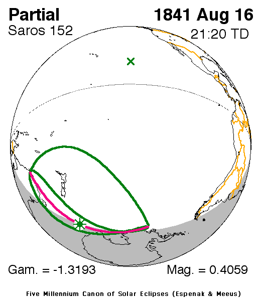
| Nature | Partial |
| Gamma | -1.3193 |
| Magnitude | 0.4059 |
| Maximum eclipse | |
| Coordinates | 61°54′S 158°00′E / 61.9°S 158°E |
| Times (UTC) | |
| Greatest eclipse | 21:20:24 |
| References | |
| Saros | 152 (3 of 70) |
| Catalog # (SE5000) | 9142 |

A partial solar eclipse occurred on August 16, 1841, during winter in the southern hemisphere. A solar eclipse occurs when the Moon passes between Earth and the Sun, thereby totally or partly obscuring the image of the Sun for a viewer on Earth. A partial solar eclipse occurs in the polar regions of the Earth when the center of the Moon's shadow misses the Earth.
It was last of four partial eclipses that took place that year, two in the space of two months each, the last one was in July 1819 and covered a part of the Northern Hemisphere.[1] It was the third solar saros 152 cycle of eclipses[2]
Description[]
The eclipse was visible in much of the Pacific Ocean and included New Zealand and other smaller islands including Cook, Chatham, Antipodes, and Norfolk Islands and a couple of others, one of them Macquarrie and Lord Howe.
The eclipse was nearly close to New Caledonia and a part of Antarctica.
The eclipse started at sunrise in Tasmania and southeastern Australia and finished at sunset at the Pacific and a tiny part of Western Antarctica. The greatest eclipse was in the Pacific Ocean hundreds of miles (or kilometers) north of Antarctica at 61.9 S & 158 E at 21:20:24 UTC (8:20 AM local time).[1]
The subsolar marking was in the Pacific north of the 10th parallel north.
See also[]
References[]
- ^ a b "Solar eclipse of August 16 1841". NASA. Retrieved March 14, 2017.
- ^ "Solar Saros 152". NASA. Retrieved March 14, 2017.
External links[]
Solar eclipses | |||||||||
|---|---|---|---|---|---|---|---|---|---|
| Lists of eclipses |
| ||||||||
 Total/hybrid eclipses → next total/hybrid |
| ||||||||
 Annular eclipses → next annular |
| ||||||||
 Partial eclipses → next partial |
| ||||||||
| Other bodies |
| ||||||||
| Related topics |
| ||||||||
| |||||||||
- Partial solar eclipses
- 1841 in science
- 19th-century solar eclipses
- August 1841 events