Solar eclipse of December 1, 1891
| Solar eclipse of December 1, 1891 | |
|---|---|
 Map | |
| Type of eclipse | |
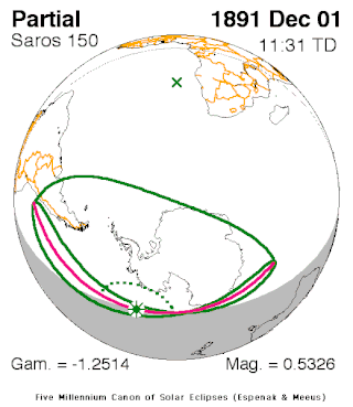
| Nature | Partial |
| Gamma | -1.2515 |
| Magnitude | 0.5326 |
| Maximum eclipse | |
| Coordinates | 64°06′S 140°54′W / 64.1°S 140.9°W |
| Times (UTC) | |
| Greatest eclipse | 11:31:08 |
| References | |
| Saros | 150 (10 of 71) |
| Catalog # (SE5000) | 9261 |

A partial solar eclipse occurred on December 1, 1891, during late spring. A solar eclipse occurs when the Moon passes between Earth and the Sun, thereby totally or partly obscuring the image of the Sun for a viewer on Earth. A partial solar eclipse occurs in the polar regions of the Earth when the center of the Moon's shadow misses the Earth.
It was the only partial eclipse that took place that year.[1] It was part of solar saros 150.[2]
Description[]
The eclipse took place in South America including Argentina and Chile (along with its capital Santiago), even Patagonia and its surrounding islands, almost all of Antarctica except for its northernmost fringes along the Indian Ocean just east of the boundary separating the Atlantic and its surrounding oceans, largely the Atlantic and the Pacific. The rim of the eclipse was close to Buenos Aires and its suburban city La Plata and Mendoza. The greatest eclipse was hundreds of miles (kilometers) offshore from Antarctica in the Pacific north of the Antarctic Circle at 64.1 S and 140.9 W at 11:31 UTC (2:30 AM local time).[1]
As the moon moved towards the left in Antarctica by the area separating the Atlantic and the Indian Oceans, it was seen as it was moved towards the bottom in South America, then right in peninsular Antarctica then top in the area of the 120th meridian east as the axis spun at around the 68th parallel south.
The eclipse started at sunrise near Valparaiso and Santiago, Chile and ended at sunset in the Indian Ocean offshore from Antarctica around the third of the way to Western Australia.
It showed up to 25-30% obscuration of the sun at South America's southern tip, 30% within the South Pole and 50% at the west of the middle portion of the Peninsula. The center of the Moon's shadow was missed by about 1,300 km above the area (67.6 S) south of the Antarctic Circle.
The subsolar marking was west of Namaqualand (then also South West Africa, now Namibia).
See also[]
References[]
- ^ a b "Solar eclipse of December 1, 1891". NASA. Retrieved March 23, 2017.
- ^ "Solar Saros 150". NASA. Retrieved March 23, 2017.
External links[]
Solar eclipses | |||||||||
|---|---|---|---|---|---|---|---|---|---|
| Lists of eclipses |
| ||||||||
 Total/hybrid eclipses → next total/hybrid |
| ||||||||
 Annular eclipses → next annular |
| ||||||||
 Partial eclipses → next partial |
| ||||||||
| Other bodies |
| ||||||||
| Related topics |
| ||||||||
| |||||||||
- Partial solar eclipses
- 1891 in science
- 19th-century solar eclipses
- December 1891 events