Solar eclipse of November 21, 1881
| Solar eclipse of November 21, 1881 | |
|---|---|
 Map | |
| Type of eclipse | |
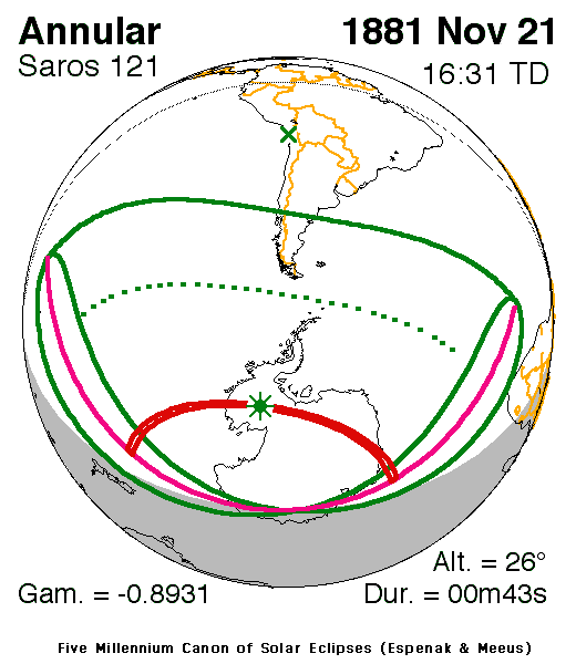
| Nature | Annular |
| Gamma | -0.8931 |
| Magnitude | 0.9887 |
| Maximum eclipse | |
| Duration | 43 sec (0 m 43 s) |
| Coordinates | 81°12′S 114°30′W / 81.2°S 114.5°W |
| Max. width of band | 90 km (56 mi) |
| Times (UTC) | |
| Greatest eclipse | 16:31:10 |
| References | |
| Saros | 121 (53 of 71) |
| Catalog # (SE5000) | 9238 |

An annular solar eclipse occurred on November 21, 1881 during spring. A solar eclipse occurs when the Moon passes between Earth and the Sun, thereby totally or partly obscuring the image of the Sun for a viewer on Earth. An annular solar eclipse occurs when the Moon's apparent diameter is smaller than the Sun's, blocking most of the Sun's light and causing the Sun to look like an annulus (ring). An annular eclipse appears as a partial eclipse over a region of the Earth thousands of kilometres wide.
It was one of two eclipses that took place that year, the only one that took place in the Southern Hemisphere.[1] It was part of solar saros 120.[2]
Description[]
The eclipse took place in the southeast portion of the Pacific and the southern part of the South Atlantic oceans. Almost all of Antarctica saw the eclipse except in areas within the 110th meridian east in which it was dark as well as South America's Patagonia (part of Argentina and Chile) and the Falklands (Malvinas) and other islands and a tiny portion of the Cape Colony (now South and North Cape), South Africa within the Atlantic in Africa. The rim of the eclipse included the area north of Puerto Montt and near the lowest point in South America.
As the moon moved towards the left on Earth in the Antarctic Peninsula, at the other side of Northern Antarctica that includes the 100th meridian, it was seen as it was moved towards the bottom right, then right then top as the axis spun at around the 69th parallel south.
The eclipse began at sunrise east of New Zealand, the Cook Islands and Wallis and Futuna and ended at sunset in the area of Cape Town. The greatest eclipse was in the Antarctic Peninsula at 81.2 S, 114.5 W at 16:31 UTC (9:31 AM local time).[1]
See also[]
References[]
- ^ a b "Solar eclipse of November 21, 1881". NASA. Retrieved March 23, 2017.
- ^ "Solar Saros 120". NASA. Retrieved March 22, 2017.
External links[]
Solar eclipses | |||||||||
|---|---|---|---|---|---|---|---|---|---|
| Lists of eclipses |
| ||||||||
 Total/hybrid eclipses → next total/hybrid |
| ||||||||
 Annular eclipses → next annular |
| ||||||||
 Partial eclipses → next partial |
| ||||||||
| Other bodies |
| ||||||||
| Related topics |
| ||||||||
| |||||||||
- Annular solar eclipses
- 1881 in science
- 19th-century solar eclipses
- November 1881 events