Solomon's Pools

Solomon's Pools (Arabic: برك سليمان, Burak Suleīmān, Solomon's Pools, or in short el-Burak, the pools; Hebrew: בריכות שלמה, Breichot Shlomo) are three ancient reservoirs located in the south-central West Bank, immediately to the south of al-Khader, about 3.5 kilometres (2.2 mi) southwest of Bethlehem, near the road to Hebron.[1][2] Although the site is traditionally associated with King Solomon,[2] modern dating techniques put the construction of the oldest, extant part to the 2nd century BCE.[3][4]
Description

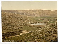
Solomon's Pools, consisting of three large reservoirs, are situated several dozen meters apart, each pool with a roughly 6 metres (20 ft) drop to the next. They are rectangular or trapezoidal in shape, partly hewn into the bedrock and partly built, between 118 and 179 metres (387–587 ft) long and 8 to 16 metres (26–52 ft) deep, with a total capacity of well over a quarter of a million cubic metres (some 290,000 m3 or 75 million US gallons).[4]
The pools were part of a complex ancient water system thought to date between 100 BCE to 30 CE. The system supplied water to Jerusalem and the Second Temple, as well as the desert fortress of Herodium.
As such, the complex of reservoirs and water conduits might have been built by Herod the Great or an earlier Hasmonean ruler. The original rectangular excavations may have been stone quarries. The pools were fed by two aqueducts, by several springs of the surrounding countryside including one situated underneath the lower pool, as well as by rainwater that descended from the hills. The pools served as a storage and distribution facility, with the two feeder aqueducts bringing water to the pools from the hills to the south. The collected water was then distributed by two other aqueducts leading from the pools northwards to Jerusalem, plus another one heading eastwards to the Herodium. Traces of all five aqueducts have been found.[4]
The pools are positioned so that the water from the high pool can flow into the lower pool next to it when the water is pumped from it. By way of an aqueduct, the water first flowed to Bethlehem, passed through an underground channel, and finally reached the Temple Mount area of Jerusalem.[5] From the pools to Bethlehem, the average drop is about 35 cm for every 270 meters, but from Bethlehem to Jerusalem it only averages 35 cm for every 1,700 meters.[5] The length of the extant aqueduct is about 2,350 meters and the slope's gradient is about 11 meters, which means a drop of less than 85 cm for every 1,600 meters.[5]
In olden times, this aqueduct, commonly called the "Lower Aqueduct," crossed the Valley of Hinnom slightly above the Sultan's Pool and passed through a number of pointed arches protruding slightly above the ground.[6] Afterwards, the aqueduct continued to meander on the southern slope of Mount Zion and entered the city near the present Jewish Quarter of the Old City.[6] It then ran along the eastern side of that hill, and was supported in part by stonework, while in other parts passed through a conduit carved from the rock, until it suddenly turned east, passed along the embankment and what is now known as Wilson's Arch, whence it entered the Temple Mount courtyard at the Chain Gate.[6]
Today, below the middle pool are the remains of the British pump station that took the water by pipe to the Old City of Jerusalem. Another, more recent pumping station below the lower pool is still providing water to the town of Bethlehem.[4]
Near the Upper Pool stands a small Turkish fort known as Qal'at el-Burak ("castle of the pools"), or Qal'at Murad ("castle of [Sultan] Murad"), now Murad or Burak Castle. The rectangular structure with four square corner towers was built by the Ottoman sultan Osman II in 1618.[7] It served as barracks for the Turkish soldiers guarding the Pools of Solomon and the commercial caravans between Jerusalem and Hebron, as well as a staging post on the local hajj route to Mecca. For a long time it was also used as a caravanserai or khan. After being allowed to decay since the middle of the 19th century, the ruined fortress has been largely rebuilt and developed as part of a new tourist complex.[7][1][8]
The Castle Museum houses one of the largest ethnographic collections of Palestinian history and culture.[9][10]
Name
The pools are named after the biblical King Solomon (around 950 BC) and linked to the passage in the Book of Ecclesiastes 2.6: "I made myself pools from which to water the forest of growing trees." Josephus wrote that Solomon enjoyed the beauty of the water-rich "Etham" (one of the main springs is called Ein Eitam = Hebrew: עין עיטם ).[11][12] The pools are in close proximity to the ancient town of ʻEiṭam (now Khirbet al-Khuaḥ) and the spring known as ʻAin ʻEiṭam. Legend has it that the king built the pools for his many wives, so that they could bathe in their waters.[13] French explorer Victor Guérin who visited the site in the late 19th-century described the source of the pools and their surrounding villages in Description de la Palestine.[14]
Tradition dates the pools to the time of King Solomon, although the masonry of one pool and a recently discovered aqueduct have been dated to the early Roman period. According to Josephus, he would pass this place when riding in his chariot.[15][16][17]
History
Background
The growing water needs of the Jerusalem Temple and the pilgrims it attracted during the later part of the Second Temple period, led to efforts to create a conduit able to reach the relatively high top of the Temple Mount by gravity alone. The hills south of Jerusalem are higher than the city and its Temple Mount, and contain a number of perennial springs, offering a good choice to the ancient engineers.[4]
Jerusalem water system
The water system gradually created consisted of two aqueducts feeding the pools, which themselves acted as a collection and distribution facility, and of three further aqueducts: two carrying the water north to Jerusalem, and a third one to Herodium. Together, the five aqueducts totalled some 80 kilometres in length.[4]
Upper pools
The construction date of the upper (westernmost) two pools is uncertain but they was probably started during the Hasmonean period, between mid-second and mid-first century BC and completed by Herod the Great in connection with his rebuilding program of the Second Temple.[1]
Wadi el-Byiar Aqueduct
Herod created the sophisticated Wadi el-Byiar Aqueduct, which fed the upper pool. The aqueduct was partially built as a tunnel which collected underground water from the aquifer it was passing through, in the way of a qanat, to supplement the spring water and surface runoff it was also carrying.[4]
Upper Aqueduct
Water from the same upper pool was taken to Jerusalem's Upper City, where Herod had erected his new palace, through the king's ambitious so-called Upper or High Level Aqueduct. North of Bethlehem a tall bridge consisting of two levels of arches helped pass a deep valley.[4]
Pilate's Arrub Aqueduct
In a third phase, Roman prefect Pontius Pilate built 39 kilometres (24 mi) of aqueduct bringing yet more water to Solomon's Pools from the large collection pools at Arrub to the south.[18] This aqueduct, which brought water to Jerusalem, was paid for by Pontius Pilate at the expense of the Temple treasury, which act in itself incited the anger of the local people.[19] During the Great Revolt the aqueduct was destroyed.[19]
Low Level Aqueduct
The Low Level Aqueduct was the longest serving of the Jerusalem-bound ones. It started at the lower pool and once it reached Jerusalem, it crossed the Tyropoeon Valley over a bridge to find its way onto the Temple Mount platform, where it ended inside the great cisterns hidden underneath its surface.[4]
Mamluk lower pool
The lower of the three pools was built in 1483 CE during the reign of Mamluk Sultan Qaytbay.[1] Between 1480 and 1484 Felix Fabri visited, and noted that beside the middle pool there were: "pavilions and tents, wherein dwelt the architects, clerks of the works, overseers, and masters, who there arranged how the watercourses should be dug through the mountains. Round about these pavilions many Moors and Saracens were running to and fro..."[20]
Later history
The water system based on Solomon's Pools has provided water to Jerusalem, on and off, for two millennia, all until 1967.[4]
Major repairs to the water system were done by the 10th Roman Legion, Legio Fretensis during the second century CE, later by the Mamluks, the Ottomans and the British. In 1902 for instance, a new 16 km pipeline to Jerusalem was inaugurated to mark the 60th birthday of the Ottoman sultan Abdul Hamid II[4][21]
Springs feeding the pools

The pools are directly fed by four different springs: the most prominent is 'Ain Saleh, at the head of the Wadi Urtas (Artas), about 200 metres (660 ft) to the north-west of the upper pool.[22][23] The spring water is transferred to the upper pool by a large subterranean passage.[24] From the same direction comes the water of 'Ain Burak. 'Ain Attan or Ein Eitam is located south-east of the lower pool, while 'Ain Farujeh is right underneath that pool.[4]
Present day
Today the water from the pools reaches only to Bethlehem. The aqueduct beyond this has been destroyed once taken out of use in 1967.[4][by whom?]
At the northern entrance to the park, the Ottoman fort has been developed as part of a tourist complex that also houses a museum of ethnography and history, and a restaurant with a garden area. Plans for the larger complex include a conference center, recreational spaces and a mosque.[8]
Solomon's Pools have been managed since 2009 by the Convention Palace Company, which operates and manages the following areas:
- Solomon's Pools, archaeological site
- Murad Castle, built for the protection of the pools
- Pine forest
- Convention halls and a theater
- Handicraft center
In 2017, the U.S. Consulate in Jerusalem funded a $750,000 restoration project at Solomon's Pools, which were suffering from neglect.[25]
The pools are located in Area A of the West Bank under the control of the Palestinian National Authority.[26]
See also
References
- ^ Jump up to: a b c d Mahmoud Hawari; Hamish Auld; Julian Hudson (1 January 2000). "Qal'at al-Burak. A Fort of the Ottoman Period South of Bethlehem". Levant: The Journal of the Council for British Research in the Levant. 32 (1): 101–120. doi:10.1179/lev.2000.32.1.101. S2CID 162056191.
- ^ Jump up to: a b Leeper, J. L. (1903). "Remains of the Temple at Jerusalem". The Biblical World. 22 (5): 340. doi:10.1086/473292. ISSN 0190-3578.
- ^ Allegro, John M. (1964). The Treasure of the Copper Scroll (2 ed.). Garden City, NY: Doubleday. p. 67. OCLC 917557044.
- ^ Jump up to: a b c d e f g h i j k l m "Solomon's Pools and relating aqueducts, the heart of Jerusalem's past water supply". HYDRIA Project. 2009. Retrieved 2014-12-18.
- ^ Jump up to: a b c Schiller, Eli, ed. (1988). Charles Wilson - Jerusalem the Holy City (צ'רלס וילסון - ירושלים העיר הקדושה) (in Hebrew). Jerusalem: Ariel. p. 131. OCLC 745100584.
- ^ Jump up to: a b c Schiller, Eli, ed. (1988). Charles Wilson - Jerusalem the Holy City (צ'רלס וילסון - ירושלים העיר הקדושה) (in Hebrew). Jerusalem: Ariel. pp. 131–132. OCLC 745100584.
- ^ Jump up to: a b "Solomon's Pools". Museum With No Frontiers. Retrieved 22 December 2014.
- ^ Jump up to: a b "Solomon's Poolsi". Solomon's Pools/Kani Mani. Retrieved 22 December 2014.
- ^ "THE MURAD CASTLE & THE SOLOMON'S POOLS". VISITOR INFORMATION CENTER – BETHLEHEM. 5 November 2012. Retrieved 14 May 2019.
Solomon’s Pools (Beraik Solayman), are located immediately to the south of al-Khader and about 5 km southwest of Bethlehem.
- ^ "DISCOVER MURAD CASTLE MUSEUM OF THE SOLOMON POOLS". Travelujah. 3 May 2017. Retrieved 14 May 2019.
The Murad Castle Museum features over 1500 precious artifacts representing many chapters of the Palestinian history. The impressive display shows various handicrafts, amulets, pottery and more. Part of a Roman Aqueduct is also displayed in the museum. In addition, a unique collection of archeological items was offered by the Palestinian Ministry of Tourism and Antiquities.
- ^ Flavius, Josephus Antiquities 8.7.3. (8:179)
- ^ Burial Places of the Fathers, published by Yehuda Levi Nahum in book: Ṣohar la-ḥasifat ginzei teiman (Heb. צהר לחשיפת גנזי תימן), Tel-Aviv 1986, p. 253, who quotes from an ancient rabbinic source: "Between Beth-Lehem and Hebron is the great pool, being the [water] duct that Hezekiah made, and the pool that he made, and it is [known as] Ein Etam." Rashi, who had not seen Josephus' writings, surmised that Ein Etam was the place known as "the waters of Nephtoah" (cf. Rashi's commentary on Yoma 31a and Zevahim 54b, s.v. עין עיטם); see also Rashi's comments on Joshua 15:8 and Deuteronomy 33.
- ^ Solomon Pools: Fit for a king, Jerusalem Post
- ^ Victor Guérin, Description de la Palestine, Judée, Description de la Judée, Paris 1869, pp. 104–119, 303–309; See: Guérin, Victor (1869). Description Géographique Historique et Archéologique de la Palestine (in French). 1: Judee, pt. 3. Paris: L'Imprimerie Nationale.
- ^ Josephus, Antiquities 8.7.3.
- ^ Biblical Encyclopaedia - Encyclopedia of the Bible and its Period (vol. 6), Bialik Institute: Jerusalem 1950-1988, pp. 186-187
- ^ D.F. Buhl, Geographie des alten Palästina, Leipzig 1896, p. 92. Buhl's words are as follows (translated from the German): "Southwest of Bethlehem, the channel from the southeast intersects another which comes from a source in the Wadi Biyyar. Where the two channels intersect, there are the famous pools of Solomon, large terraced water reservoirs, also fed by independent springs, namely ʻAin el-Burak on the northwest corner of the upper pool, which connects to another source ʻAin Ṣâliḥ, and of ʻAin Farûğe at the bottom of the lower pool; further down the channel intersects the source of ʻAṭân coming from the southern side of the valley. This source of the ʻAṭân is mentioned in the Talmud as the source ʻEṭâm, although the remark that it was 23 cubits higher than the floor of the Temple court clearly points to the aqueduct. Josephus speaks of the springs in Etan and of Solomon's Gardens there, with which Ecclesiastes 2:5 can be compared."
- ^ Murphy-O'Connor, Jerome (2008) The Holy Land: An Oxford Archaeological Guide from Earliest Times to 1700 Oxford University Press US, ISBN 0-19-923666-6 p 483
- ^ Jump up to: a b Amihai Mazar (1972), p. 120
- ^ Fabri, 1893, p. 202
- ^ Bussow, 2011, pp. 497, 536
- ^ List of Geographical Names, (A Memo of the National Committee to the Government of the Land of Israel on the Method of Spelling Transliterated Geographical and Personal Names, plus Two Lists of Geographical Names), Lĕšonénu: A Journal for the Study of the Hebrew Language and Cognate Subjects, Benjamin Maisler, Tel-Aviv 1932, p. 21 (note 1): "The spring of Etam is [called] Ein Etam, but Etam is the ruin of Wadi Khukh, near Artas (Urtas)."
- ^ See p. 21 (note 1) in: Maisler, Benjamin (1932). "A Memo of the National Committee to the Government of the Land of Israel on the Method of Spelling Transliterated Geographical and Personal Names, plus Two Lists of Geographical Names". Lĕšonénu: A Journal for the Study of the Hebrew Language and Cognate Subjects. 4 (3): 1–92. JSTOR 24384308. (Hebrew)
- ^ Bromiley Geoffrey W (1995). The International Standard Bible Encyclopedia: E-J Wm. B. Eerdmans Publishing, ISBN 0-8028-3782-4 p 1025
- ^ Temple-era pools near Jerusalem set for renovation
- ^ Blumenthal, Itay (2016-05-09). "Second Temple era archaeological site suffer serious damage". ynetnews. Retrieved 2019-05-15.
Bibliography
- Biblical Encyclopaedia (1950-1988). Bialik Institute: Jerusalem OCLC 741065210
- Bromiley, G.W. (1995). The International Standard Bible Encyclopedia. E-J Wm. B. Eerdmans Publishing. ISBN 0-8028-3782-4.
- Buhl, D.F. (1896). Geographie des alten Palästina. Leipzig: J.C.B. Mohr (Paul Siebeck).
- Büssow, J. (2011). Hamidian Palestine: Politics and Society in the District of Jerusalem 1872-1908. BRILL. ISBN 978-9004205697.
- Schick, C. (1878). "Die Wasserversorgung der Stadt Jerusalem". Zeitschrift des Deutschen Palästina-Vereins. 1: 132–176.
- Fabri, F. (1893). Felix Fabri (circa 1480–1483 A.D.) vol II, part I. Palestine Pilgrims' Text Society.
- Flavius, Josephus. Antiquities
- Guérin, V. (1869). Description Géographique Historique et Archéologique de la Palestine (in French). 1: Judee, pt. 3. Paris: L'Imprimerie Nationale.
- Mazar, A. (1972). "The Ancient Aqueducts of Jerusalem". Qadmoniot: A Journal for the Antiquities of Eretz-Israel and Bible Lands. 5 (3/4 (19/20)): 120–124. JSTOR 23670359. (Hebrew)
- Murphy-O'Connor, J. (2008). The Holy Land: An Oxford Archaeological Guide from Earliest Times to 1700. Oxford University Press US. ISBN 978-0-19-923666-4.
- Shomali, Q.; Shomali, Sawsan. A Guide to Bethlehem and its Surroundings. Waldbrol: Flamm Druck, Wagener GMBH.
External links
- www.solomonpools.com/
 Media related to Solomon's Pools at Wikimedia Commons
Coordinates: 31°41′22.5″N 35°10′03.1″E / 31.689583°N 35.167528°E


- Al-Khader
- Aqueducts
- Bethlehem
- Caravanserais in the State of Palestine
- Reservoirs in the West Bank
- Roman aqueducts outside Rome
- Roman cisterns
- Solomon
- Tourist attractions in the State of Palestine
- Ancient Jewish history