Sorigny
Sorigny | |
|---|---|
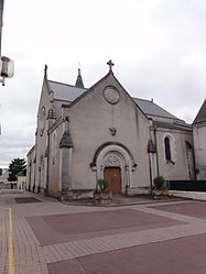 The church of Saint-Pierre-ès-Liens, in Sorigny | |
 Coat of arms | |
show Location of Sorigny | |
 Sorigny | |
| Coordinates: 47°14′33″N 0°41′46″E / 47.2425°N 0.6961°ECoordinates: 47°14′33″N 0°41′46″E / 47.2425°N 0.6961°E | |
| Country | France |
| Region | Centre-Val de Loire |
| Department | Indre-et-Loire |
| Arrondissement | Tours |
| Canton | Monts |
| Government | |
| • Mayor (2020–2026) | Alain Esnault[1] |
| Area 1 | 43.43 km2 (16.77 sq mi) |
| Population (Jan. 2018)[2] | 2,683 |
| • Density | 62/km2 (160/sq mi) |
| Time zone | UTC+01:00 (CET) |
| • Summer (DST) | UTC+02:00 (CEST) |
| INSEE/Postal code | 37250 /37250 |
| Elevation | 68–123 m (223–404 ft) |
| 1 French Land Register data, which excludes lakes, ponds, glaciers > 1 km2 (0.386 sq mi or 247 acres) and river estuaries. | |


Sorigny (French pronunciation: [sɔʁiɲi] (![]() listen)) is a commune in the Indre-et-Loire department in central France.
listen)) is a commune in the Indre-et-Loire department in central France.
Sorigny has been twinned with the village of Box, in Wiltshire, Great Britain, since 2016.
History[]
It is a parish that was confirmed in March 1031 by a charter of Robert II of France. It was formerly divided into two fiefs.
Hydrography[]
The municipal hydrographic network, with a total length of 31.09 km, includes two notable rivers, the Bourdin (3.075 km) and the Montison (2.731 km), and ten small rivers that flow at certain times.
The Bourdin, with a total length of 14.8 km, rises in the commune of Louans and flows into the Indre at Veigné after crossing five communes.
Transport[]
Transport in Sorigny is managed by the Centre-Val de Loire region and trains are operated by Transdev Touraine on the Rémi rail network. There are links between Tours and Sorigny via lines G, H, H1 and H2.
Economy[]
In 2018, the commune planned to establish a "brand village" on 20 hectares of its territory, near the A10 autoroute. Sorigny belongs to the Touraine Indre Valley community of towns (Communauté de communes Touraine Vallée de l'Indre).
Population[]
|
|
Notable residents[]
- Marcel Gaumont (1880–1962), a sculptor, was born there.
Town twinning[]
 Box, Wiltshire, Great Britain
Notable buildings and monuments[]
- Église romane Saint-Pierre-ès-Liens (Saint-Pierre-ès-Liens Church), built in the 11th century and rebuilt in 1866 by Étienne Guérin Charles Gustavus.
- Château de Longue Plaine (Longue-Plaine Castle), built in the 19th century except for two towers that are from the 15th and 16th centuries.
- Le Monument aux Morts (The War Memorial) of 1914–1918, made by the sculptor Marcel Gaumont and the architect Maurice Boille.
- Aérodrome de Tours (Aerodrome of Tours) in Sorigny.
Gallery[]
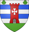
Coat of arms of Sorigny

War memorial in a cemetery (monument aux morts)

Communal war memorial

Stained glass window in the church of Saint-Pierre-ès-Liens

Wind turbine (éolienne)
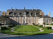
Longue-Plaine Castle in Sorigny


See also[]
- Communes of the Indre-et-Loire department
- Marcel Gaumont Sculptor of war memorial
References[]
- ^ "Répertoire national des élus: les maires". data.gouv.fr, Plateforme ouverte des données publiques françaises (in French). 2 December 2020.
- ^ "Populations légales 2018". INSEE. 28 December 2020.
| Wikimedia Commons has media related to Sorigny. |
This Indre-et-Loire geographical article is a stub. You can help Wikipedia by . |
- Communes of Indre-et-Loire
- Indre-et-Loire geography stubs