Three Rivers, California
Three Rivers | |
|---|---|
Census designated place | |
 Location in Tulare County and the state of California | |
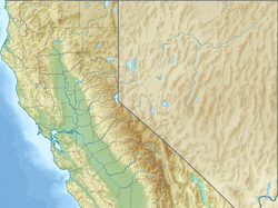 Three Rivers Location in the United States | |
| Coordinates: 36°27′15″N 118°53′11″W / 36.45417°N 118.88639°WCoordinates: 36°27′15″N 118°53′11″W / 36.45417°N 118.88639°W | |
| Country | |
| State | |
| County | Tulare |
| Area | |
| • Total | 44.505 sq mi (115.269 km2) |
| • Land | 44.505 sq mi (115.269 km2) |
| • Water | 0 sq mi (0 km2) 0% |
| Elevation | 843 ft (257 m) |
| Population (April 1, 2010) | |
| • Total | 2,182 |
| • Density | 49/sq mi (19/km2) |
| Time zone | UTC−8 (Pacific) |
| • Summer (DST) | UTC−7 (PDT) |
| ZIP code | 93271 |
| Area code | 559 |
| FIPS code | 06-78638 |
| GNIS feature IDs | 1661569, 2409316 |


Three Rivers is an unincorporated community in Tulare County, California, United States. Located in the foothills of the Sierra Nevada at the edge of the San Joaquin Valley, the town is near the entrance to the national parks of Sequoia and Kings Canyon. The town's name comes from its location near the junction of the North, Middle, and South Forks of the Kaweah River.[3][4]
The population was 2,182 at the 2010 census, down from 2,248 at the 2000 census. For statistical purposes, the United States Census Bureau has defined Three Rivers as a census-designated place (CDP). The census definition of the area may not precisely correspond to local understanding of the area with the same name.
The two national parks, which border the town to the northeast, are the prime attraction of Three Rivers.
Geography[]
Three Rivers is located in the Kaweah River canyon, just above Lake Kaweah. Surrounding terrain is marked by oak woodland forest and foothills. The Kaweah River drainage is a very short river drainage, and quickly terrain climbs from around 1,000 feet (300 m). ASL in Three Rivers to 3,000-5,000 ft ASL on the surrounding hills, and upward to 14,000+ ft ASL at Mt. Whitney, fifty miles to the East. According to the United States Census Bureau, the CDP has a total area of 44.5 square miles (115 km2), all land.

Climate[]
| hideClimate data for Three Rivers, California | |||||||||||||
|---|---|---|---|---|---|---|---|---|---|---|---|---|---|
| Month | Jan | Feb | Mar | Apr | May | Jun | Jul | Aug | Sep | Oct | Nov | Dec | Year |
| Record high °F (°C) | 79 (26) |
85 (29) |
89 (32) |
100 (38) |
106 (41) |
112 (44) |
112 (44) |
114 (46) |
109 (43) |
102 (39) |
88 (31) |
78 (26) |
114 (46) |
| Average high °F (°C) | 58.7 (14.8) |
63.0 (17.2) |
68.0 (20.0) |
74.4 (23.6) |
84.0 (28.9) |
92.6 (33.7) |
99.0 (37.2) |
97.9 (36.6) |
92.3 (33.5) |
80.5 (26.9) |
66.2 (19.0) |
58.2 (14.6) |
77.9 (25.5) |
| Average low °F (°C) | 35.4 (1.9) |
38.3 (3.5) |
41.3 (5.2) |
44.3 (6.8) |
50.8 (10.4) |
58.0 (14.4) |
64.3 (17.9) |
63.1 (17.3) |
57.8 (14.3) |
48.7 (9.3) |
40.1 (4.5) |
35.1 (1.7) |
48.1 (8.9) |
| Record low °F (°C) | 20 (−7) |
19 (−7) |
23 (−5) |
22 (−6) |
33 (1) |
39 (4) |
33 (1) |
32 (0) |
28 (−2) |
26 (−3) |
23 (−5) |
16 (−9) |
16 (−9) |
| Average precipitation inches (mm) | 4.58 (116) |
4.33 (110) |
4.22 (107) |
2.16 (55) |
0.93 (24) |
0.31 (7.9) |
0.09 (2.3) |
0.02 (0.51) |
0.48 (12) |
1.12 (28) |
2.70 (69) |
3.90 (99) |
24.83 (631) |
| Average precipitation days (≥ 0.01 in) | 7.7 | 8.6 | 8.4 | 6.0 | 2.7 | 0.7 | 0.5 | 0.3 | 1.1 | 3.0 | 5.5 | 7.8 | 52.4 |
| Source: NOAA (normals 1981−2010)[6] | |||||||||||||
Demographics[]
2010[]
The 2010 United States Census[7] reported that Three Rivers had a population of 2,182. The population density was 49.0 per square mile (18.9/km2). The racial make-up was 1,976 (90.6%) White, 7 (0.3%) African American, 27 (1.2%) Native American, 31 (1.4%) Asian, 1 (0.0%) Pacific Islander, 75 (3.4%) from other races and 65 (3.0%) from two or more races. Hispanic or Latino of any race were 212 people (9.7%).
The Census reported that 2,177 people (99.8% of the population) lived in households, 0 (0%) lived in non-institutionalized group quarters and 5 (0.2%) were institutionalized.
There were 1,018 households, of which 207 (20.3%) had children under the age of 18 living in them, 519 (51.0%) were opposite-sex married couples living together, 65 (6.4%) had a female householder with no husband present, 33 (3.2%) had a male householder with no wife present. There were 35 (3.4%) unmarried opposite-sex partnerships, and 10 (1.0%) same-sex married couples or partnerships. 341 households (33.5%) were made up of individuals and 159 (15.6%) had someone living alone who was 65 years of age or older. The average household size was 2.14. There were 617 families (60.6% of all households); the average family size was 2.71.
354 people (16.2%) were under the age of 18, 90 people (4.1%) aged 18 to 24, 369 people (16.9%) aged 25 to 44, 837 people (38.4%) aged 45 to 64 and 532 people (24.4%) who were 65 years of age or older. The median age was 52.3 years. For every 100 females, there were 98.2 males. For every 100 females age 18 and over, there were 93.4 males.
There were 1,312 housing units at an average density of 29.5 per square mile (11.4/km2), of which 741 (72.8%) were owner-occupiedand 277 (27.2%) were occupied by renters. The homeowner vacancy rate was 3.1%; the rental vacancy rate was 7.6%. 1,604 people (73.5% of the population) lived in owner-occupied housing units and 573 people (26.3%) lived in rental housing units.
2000[]
Ats of the 2000 census,[8] there were 2,248 people, 985 households and 659 families residing in the CDP. The population density was 49.6 per square mile (19.2/km2). There were 1,217 housing units at an average density of 26.8 per square mile (10.3/km2). The racial make-up was 89.86% White, 0.22% African American, 1.29% Native American, 0.67% Asian, 0.13% Pacific Islander, 3.74% from other races and 4.09% from two or more races. Hispanic or Latino of any race were 6.58% of the population.
There were 985 households, of which 24.3% had children under the age of 18 living with them, 54.9% were married couples living together, 7.6% had a female householder with no husband present and 33.0% were non-families. 27.4% of all households were made up of individuals and 12.2% had someone living alone who was 65 years of age or older. The average household size was 2.28 and the average family size was 2.75.
20.9% of the population were under the age of 18, 4.6% from 18 to 24, 20.3% from 25 to 44, 32.1% from 45 to 64 and 22.1% were 65 years of age or older. The median age was 47 years. For every 100 females, there were 94.1 males. For every 100 females age 18 and over, there were 94.5 males.
The median household income was $42,727 and the median family income was $48,843. Males had a median income of $39,355 and females $31,875. The per capita income was $23,475. About 7.5% of families and 9.8% of the population were below the poverty line, including 14.3% of those under age 18 and 6.4% of those age 65 or over.
History[]
Kaweah Colony[]
In 1886, a group of utopian socialists founded an intentional community along the upper North Fork of the Kaweah River. Named Kaweah Colony, it was inspired by the ideas of Laurence Gronlund. When Congress created Sequoia National Park they lost their timber claims and in 1891 were ordered off the land.[9]
Rhodesian pioneers[]
The Three Rivers cemetery contains the bodies of nine Rhodesian pioneers who lived in Africa ca. 1900 and fought in several wars. The Burnham and Blick families started a 5,000-acre (20 km2) cattle ranch, La Cuesta, in Three Rivers and built homes there. The scenery at Three Rivers is said to be almost identical to that of the Rhodesian kopje country.[10] La Cuesta was sold by John and Judd Blick in 1947 for $90,000.[11]
Mineral King and Walt Disney[]
In the 1960s and 70s, Walt Disney had plans to develop a ski resort at Mineral King. Ultimately, these plans were withdrawn when Mineral King was annexed into Sequoia National Park in 1978.
Artists' colony[]

In the 1960s several local artists held exhibitions in the old Apple House on the North Fork Drive. Some of these artists included Adrian Green, Gene Gray, Caroll Barnes, Frank Treuting, Jean Caulfeild and Pauline Whitsun. Present day artists open their studios every other year for the Three Rivers Artists' Biennial Studio Tour, which was started in 1994 by Elsah Cort (then associated with the Cort Gallery.) More than thirty artists are living and working in Three Rivers, including Mona Fox Selph, James Entz, and Aranga Firstman, who all taught at College of the Sequoias in Visalia, California. Other well-known artists are Martha Widmann, Rick Badgley, Jana Botkin, Nikki Crain, Tina St. John, Nadi Spencer and Martin Pugh.
The Arts Alliance of Three Rivers is the local arts organization, started in 1985, with many local artists and art patrons as members. It sponsors the annual Redbud Arts and Craft Festival every May. It also established the Lorraine Young Scholarship Fund, which awards art scholarships to local Three Rivers graduating high school students. This fund was established by the Arts Alliance in honor of the many years of service Lorraine gave to both the Arts Alliance and to the community of Three Rivers. The Arts Alliance became a 501(c)(3) tax exempt organization in 2010.
Politics[]

In the state legislature, Three Rivers is located in the 18th Senate District, represented by Republican Jean Fuller and formerly held by Republican Roy Ashburn, and in the 23rd Assembly District, represented by Republican Jim Patterson.[12]
In the United States House of Representatives, Three Rivers is in California's 23rd congressional district, represented by Republican Kevin McCarthy.[13]
Schools[]
- Three Rivers Union School District (K-8, average attendance: 157 students)[14]
- Woodlake Union High School (9-12), Three Rivers Students usually go to high school in Woodlake, CA
Three Rivers is the location of the Diocese of Fresno's St. Anthony Retreat Center and Santa Teresita Youth Conference Center, and of Riata Ranch International, a world-renowned[citation needed] Western Performance Arts Training Facility and home of the world famous[citation needed] Riata Ranch Cowboy Girls.
Three Rivers was one site of a handful of U.S. boarding schools run by the Hare Krishna movement. These schools, called "gurukulas", were closed by the mid-1980s. Other locations included Los Angeles, Moundsville in West Virginia and Dallas.
Notable people[]
- Mary Harris - longtime Three Rivers resident and noted musician.
- Curt Siodmak (August 10, 1902 – September 2, 2000) was a German-American novelist and screenwriter, who was a longtime resident of Three Rivers with his wife Henrietta (November 14, 1903 - May 10, 2001).[15]
References[]
- ^ "2010 Census U.S. Gazetteer Files – Places – California". United States Census Bureau.
- ^ "Three Rivers". Geographic Names Information System. United States Geological Survey. Retrieved February 25, 2015.
- ^ Sahagun, Louis (December 23, 2016). "A black bear boom has a California town wondering how residents would get along with grizzlies". Los Angeles Times. Retrieved January 2, 2017.
- ^ Rocha, Veronica; Serna, Joseph (November 9, 2015). "Baby bear boom brings many of them to streets of Three Rivers, Calif". Los Angeles Times. Retrieved January 2, 2017.
- ^ Case Mountain BLM Recreation Management Area, CA
- ^ "NOWData - NOAA Online Weather Data". National Oceanic and Atmospheric Administration. Retrieved December 10, 2012.
- ^ "2010 Census Interactive Population Search: CA - Three Rivers CDP". U.S. Census Bureau. Archived from the original on July 15, 2014. Retrieved July 12, 2014.
- ^ "U.S. Census website". United States Census Bureau. Retrieved 2008-01-31.
- ^ "The History of Kaweah Colony". The Kaweah Commonwealth. Archived from the original on 15 April 2012. Retrieved March 3, 2012.
- ^ Lott, J. "Jack" P (March 1977). "Major F. R. Burnham, D.S.O". Rhodesiana Magazine. 36: 68. ISSN 0556-9605.
- ^ "Ranch Sells for $90,000". Los Angeles Times. February 8, 1947.
- ^ "Statewide Database". UC Regents. Archived from the original on February 1, 2015. Retrieved October 22, 2014.
- ^ "California's 23rd Congressional District - Representatives & District Map". Civic Impulse, LLC. Retrieved October 6, 2014.
- ^ "School Districts". Tulare County Office of Education. Retrieved February 25, 2015.
- ^ FREYERMUTH, GUNDOLF S. FREYERMUTH (September 14, 1997). "Despite His Fate, He Found His Fortune". Los Angeles Times. Retrieved July 12, 2020.
External links[]
| Wikivoyage has a travel guide for Three Rivers. |
- The Kaweah Commonwealth: Weekly newspaper and visitor information online
- Three Rivers Village information
- Sequoia Foothills Chamber of Commerce
- Blog about happenings in the Three Rivers area
- Sequoia and Kings Canyon official website
- Three Rivers Historical Museum
| show Municipalities and communities of Tulare County, California, United States |
|---|

| show Authority control |
|---|
- Census-designated places in Tulare County, California
- Populated places in the Sierra Nevada (U.S.)
- San Joaquin Valley