Trombay
This article needs additional citations for verification. (September 2010) |
This article possibly contains original research. (August 2017) |
Trombay | |
|---|---|
Suburb | |
 Trombay Location in Mumbai, India | |
| Coordinates: 19°00′N 72°54′E / 19.0°N 72.9°ECoordinates: 19°00′N 72°54′E / 19.0°N 72.9°E | |
| Country | |
| State | Maharashtra |
| District | Mumbai Suburban |
| City | Mumbai |
| Government | |
| • Type | Municipal Corporation |
| • Body | Brihanmumbai Municipal Corporation (MCGM) |
| Languages | |
| • Official | Marathi |
| Time zone | UTC+5:30 (IST) |

Trombay is an eastern suburb in Bombay (Mumbai), India.
History[]

Atomic Reactor Trombay on 1965 stamp of India.
Trombay was called Neat's Tongue because of its shape. Once, it was an island nearly 5 km East of Mumbai and was about 8 km in length and 8 km in width. The island contains several ruins of Portuguese churches from the 1620s and 1630s.[1]
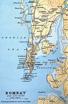
1893 map showing Trombay
In 1928, the Great Indian Peninsular Railway opened the Trombay-Andheri line called the Salsette Trombay Railway or Central Salsette Tramway.[2]
See also[]
References[]
- ^ Gazetteers of the Bombay Presidency - Thana - http://www.maharashtra.gov.in/pdf/gazeetter_reprint/Thane-III/places_Trombay.html - Retrieved on 3 December 2010.
- ^ Times of India - Chembur-Ghatkopar Plus - "Archived copy". Archived from the original on 15 May 2011. Retrieved 3 December 2010.
{{cite web}}: CS1 maint: archived copy as title (link) - Retrieved on 3 December 2010
Categories:
- Cities and towns in Mumbai Suburban district