Worli
This article has multiple issues. Please help or discuss these issues on the talk page. (Learn how and when to remove these template messages)
|
Worli | |
|---|---|
Neighbourhood | |
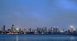 Worli skyline as seen from Bandra | |
 Worli | |
| Coordinates: 19°00′00″N 72°48′54″E / 19.00°N 72.815°ECoordinates: 19°00′00″N 72°48′54″E / 19.00°N 72.815°E | |
| Country | India |
| State | Maharashtra |
| District | Mumbai City |
| City | Mumbai |
| Government | |
| • Type | Municipal Corporation |
| • Body | Brihanmumbai Municipal Corporation (MCGM) |
| Demonym(s) | Worlikar, Varalikar |
| Languages | |
| • Official | Marathi |
| Time zone | UTC+5:30 (IST) |
| PIN | 400018 and 400030 |
| Area code(s) | 022 |
| Vehicle registration | MH 01 |
| Civic agency | BMC |


Bandra-Worli Sea Link, with Worli skyline
Worli (ISO: Varaḷī, [ʋəɾ(ə)ɭiː]) is a locality in South Mumbai, Maharashtra. It is one of the four peninsulas of Mumbai while the other being Colaba, Bandra and Malabar Hill. The sea connects it with Bandra via the Bandra-Worli Sea Link. Historic spellings include Warli, Worlee, Varli, and Varel.[1] Originally Worli was a separate island, one of the Seven Islands of Bombay which were ceded by the Portuguese to England in 1661; it was linked up with the other islands in the 19th century.
In the 1990s, a group of terrorists attacked a building in Worli as well as major buildings in the city.[2]
See also[]
References[]
- ^ D'Cunha, Jose Gerson (1900). "IV The Portuguese Period". The Origins of Bombay (3 ed.). Bombay: Asian Educational Services. p. 265. ISBN 81-206-0815-1. Retrieved 4 January 2009.
- ^ "Archived copy". articles.timesofindia.indiatimes.com. Archived from the original on 17 October 2012. Retrieved 12 January 2022.
{{cite web}}: CS1 maint: archived copy as title (link)
Categories:
- Suburbs of Mumbai