U.S. Route 62 in Texas
 | ||||
|---|---|---|---|---|
 | ||||
| Route information | ||||
| Maintained by TxDOT | ||||
| Length | 403.744 mi[1] (649.763 km) | |||
| Existed | 1932[1]–present | |||
| West Texas | ||||
| West end | ||||
| Major intersections | ||||
| East end | ||||
| South Plains | ||||
| West end | ||||
| Major intersections | ||||
| East end | ||||
| Location | ||||
| Counties | El Paso, Hudspeth, Culberson; Gaines, Terry, Hockley, Lubbock, Crosby, Floyd, Motley, Cottle, Childress | |||
| Highway system | ||||
| ||||
U.S. Route 62 (US 62) is a US highway that runs from the Mexico–US border at El Paso, TX to the Canada-US border at Niagara Falls, NY. In Texas, the highway exists in two segments separated by a segment in New Mexico. US 62 is a major corridor in West Texas as it connects the cities of El Paso and Lubbock.
Route description[]
Trans-Pecos[]
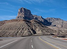
US 62 begins at the Santa Fe Street Bridge at the Mexico–US border in El Paso concurrent with U.S. Route 85. US 62 ends its overlap with US 85 and runs along E. Paisano Drive through Downtown El Paso. The highway runs northeast and passes by the Chamizal National Memorial before interchanging with Interstate 110 and U.S. Route 54. US 62 continues to run along E. Paisano Drive and has a short overlap with State Highway 20, which both enters and leaves via a traffic circle. The highway meets Interstate 10, where it begins an overlap with U.S. Route 180. Just north of I-10, US 62/180 leave E. Paisano Drive and begin to run along Montana Avenue, passing just south of El Paso International Airport. The section of Montana Avenue from Global Reach Drive/N. Yarbrough Drive to Rich Beem Boulevard runs along the reservation line to Fort Bliss. Development begins to steadily decrease along the highway east of Loop 375 as US 62 runs through the communities of Homestead Meadows North/Homestead Meadows South, Butterfield, and Montana Vista. After leaving El Paso County, the highway runs through sparsely populated areas and the town of Pine Springs near Guadalupe Mountains National Park. The highway winds through the Guadalupe Mountains before crossing into New Mexico.
South Plains[]
US 62/180 reenters Texas from New Mexico between Hobbs and Seminole. US 62 ends its overlap with US 180 in Seminole and begins an overlap with U.S. Route 385. The two highways run north-northeast through the towns of Seagraves and Wellman before entering Brownfield. In Brownfield, US 62 has a short overlap with U.S. Route 380 and State Highway 137 and begins an overlap with U.S. Route 82. US 385 leaves the concurrency in the northern part of the town. US 62/82 run through the towns of Meadow and Ropesville before entering metro Lubbock and the town of Wolfforth. The highway bypasses the town as a freeway and enters Lubbock near the 82nd Street exit. US 62/82 becomes a divided highway between 82nd Street and Spur 327 before becoming a freeway again, which is known locally as the Marsha Sharp Freeway. US 62 runs along the Marsha Sharp Freeway through a heavily developed area of southwest Lubbock before leaving US 82 at State Highway 114. US 62/SH 114 run through the heart of the city on 19th Street before becoming Idalou Road at Martin Luther King, Jr. Boulevard. The highway rejoins US 82 near the East Loop 289 interchange. The highways run northeast out of the city before turning in a predominately east direction in Idalou.
US 62 leaves US 82/SH 114 in Ralls before beginning a concurrency with State Highway 207. The highway's concurrency with SH 207 ends in Floydada, with US 62 beginning an overlap with U.S. Route 70. US 62 has a lengthy overlap with US 70 that lasts from Floydada to Paducah. In Paducah, US 62 begins an overlap with U.S. Route 83, with the two highways running through Childress. US 62 ends its overlap with US 83 just north of the Prairie Dog Town Fork Red River and exits the state into Oklahoma a few miles west of Hollis.
Junction list[]
This section contains a table that is missing mileposts for one or more junctions. |
| County | Location | mi | km | Destinations | Notes | ||
|---|---|---|---|---|---|---|---|
| El Paso | El Paso | Mexican border; west end of US 85 overlap | |||||
| East end of US 85 overlap | |||||||
| Interchange | |||||||
| US 54 exit 20A | |||||||
| Traffic circle; west end of SH 20 overlap | |||||||
| Traffic circle; east end of SH 20 overlap | |||||||
| West end of US 180 overlap; I-10 exit 23B | |||||||
| Loop 375 exit 35 | |||||||
| Interchange | |||||||
| | |||||||
| Hudspeth | Cornudas | ||||||
| | |||||||
| | |||||||
| Salt Flat | |||||||
| Culberson | | ||||||
| | |||||||
| | New Mexico state line | ||||||
| US 62 crosses through New Mexico | |||||||
| Gaines | | New Mexico state line | |||||
| | |||||||
| | |||||||
| Seminole | |||||||
| East end of US 180 overlap; west end of US 385 overlap | |||||||
| Seagraves | |||||||
| Terry | Wellman | South end of FM 303 overlap | |||||
| | North end of FM 303 overlap | ||||||
| Brownfield | West end of SH 137 overlap | ||||||
| East end of SH 137 overlap | |||||||
| West end of US 82/380 overlap | |||||||
| East end of US 380 overlap | |||||||
| East end of US 385 overlap | |||||||
| | |||||||
| Meadow | |||||||
| Hockley | Ropesville | ||||||
| Lubbock | | West end of FM 1585 overlap | |||||
| | East end of FM 1585 overlap | ||||||
| Wolfforth | West end of freeway | ||||||
| East end of freeway | |||||||
| Lubbock | Upland Avenue | ||||||
| West end of freeway; eastbound exit and westbound entrance | |||||||
| Milwaukee Avenue | |||||||
| 34th Street/Slide Road | |||||||
| Quaker Avenue | |||||||
| East end of US 82 overlap; west end of SH 114 overlap; east end of freeway | |||||||
| I-27 exit 3 | |||||||
| Interchange; west end of US 82 overlap | |||||||
| | |||||||
| | West end of FM 1724 overlap | ||||||
| | East end of FM 1724 overlap | ||||||
| Idalou | |||||||
| | West end of FM 789 overlap | ||||||
| | East end of FM 789 overlap | ||||||
| Crosby | Lorenzo | West end of FM 378 overlap | |||||
| East end of FM 378 overlap | |||||||
| | |||||||
| | |||||||
| Ralls | East end of US 82/SH 114 overlap | ||||||
| South end of SH 207 overlap | |||||||
| | |||||||
| Cone | |||||||
| Floyd | | ||||||
| | |||||||
| Floydada | West end of US 70 overlap | ||||||
| East end of SH 207 overlap | |||||||
| | |||||||
| | |||||||
| | West end of FM 28 overlap | ||||||
| | East end of FM 28 overlap | ||||||
| Motley | Matador | ||||||
| | |||||||
| Cottle | | ||||||
| Paducah | East end of US 70 overlap; west end of US 83 overlap | ||||||
| West end of FM 1037 overlap | |||||||
| East end of FM 1037 overlap | |||||||
| | |||||||
| | |||||||
| | |||||||
| | |||||||
| Childress | | ||||||
| | |||||||
| Childress | |||||||
| | |||||||
| | Bridge over Prairie Dog Town Fork Red River | ||||||
| | East end of US 83 overlap | ||||||
| | |||||||
| | |||||||
| | Oklahoma state line | ||||||
1.000 mi = 1.609 km; 1.000 km = 0.621 mi
| |||||||
References[]
- ^ a b Transportation Planning and Programming Division (n.d.). "U.S. Highway No. 62". Highway Designation Files. Texas Department of Transportation. Retrieved October 1, 2016.
- Transportation in Childress County, Texas
- Transportation in Cottle County, Texas
- Transportation in Crosby County, Texas
- Transportation in Culberson County, Texas
- Transportation in El Paso County, Texas
- Transportation in El Paso, Texas
- Transportation in Floyd County, Texas
- Transportation in Gaines County, Texas
- Transportation in Hockley County, Texas
- Transportation in Hudspeth County, Texas
- Transportation in Lubbock County, Texas
- Transportation in Lubbock, Texas
- Transportation in Motley County, Texas
- Transportation in Terry County, Texas
- U.S. Route 62
- U.S. Highways in Texas