Lubbock County, Texas
Lubbock County | |
|---|---|
U.S. county | |
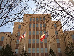 The current Lubbock County Courthouse | |
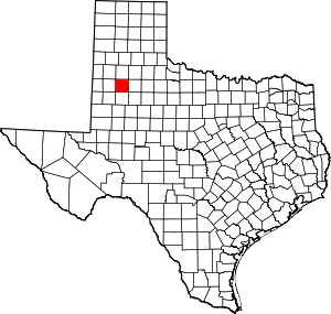 Location within the U.S. state of Texas | |
 Texas's location within the U.S. | |
| Coordinates: 33°37′N 101°49′W / 33.61°N 101.82°W | |
| Country | |
| State | |
| Founded | 1891 |
| Named for | Thomas Saltus Lubbock |
| Seat | Lubbock |
| Largest city | Lubbock |
| Area | |
| • Total | 901 sq mi (2,330 km2) |
| • Land | 896 sq mi (2,320 km2) |
| • Water | 5.1 sq mi (13 km2) 0.6%% |
| Population | |
| • Estimate (2019) | 310,569 |
| • Density | 332.36/sq mi (128.32/km2) |
| Time zone | UTC−6 (Central) |
| • Summer (DST) | UTC−5 (CDT) |
| Congressional district | 19th |


Lubbock County is a county located in the U.S. state of Texas. The 2010 census placed the population at 278,831, and as of 2019, it's estimated to have increased to 310,569.[1] Its county seat and largest city is Lubbock.[2] The county was created in 1876 and organized in 1891.[3] It is named for Thomas Saltus Lubbock,[4] a Confederate colonel and Texas Ranger (some sources give his first name as Thompson).
Lubbock County, along with Crosby County, and Lynn County, is part of the Lubbock Metropolitan Statistical Area (MSA). The Lubbock MSA and Levelland Micropolitan Statistical Area, encompassing only Hockley County, form the larger Lubbock–Levelland Combined Statistical Area.
Geography[]
According to the U.S. Census Bureau, the county has a total area of 901 square miles (2,330 km2), of which 896 square miles (2,320 km2) are land and 5.1 square miles (13 km2) (0.6%) are covered by water.[5]
Major highways[]
Adjacent counties[]
- Hale County (north)
- Crosby County (east)
- Lynn County (south)
- Hockley County (west)
- Lamb County (northwest)
- Terry County (southwest)
- Garza County (southeast)
- Floyd County (northeast)
Demographics[]
| Historical population | |||
|---|---|---|---|
| Census | Pop. | %± | |
| 1880 | 25 | — | |
| 1890 | 33 | 32.0% | |
| 1900 | 293 | 787.9% | |
| 1910 | 3,624 | 1,136.9% | |
| 1920 | 11,096 | 206.2% | |
| 1930 | 39,104 | 252.4% | |
| 1940 | 51,782 | 32.4% | |
| 1950 | 101,048 | 95.1% | |
| 1960 | 156,271 | 54.7% | |
| 1970 | 179,295 | 14.7% | |
| 1980 | 211,651 | 18.0% | |
| 1990 | 222,636 | 5.2% | |
| 2000 | 242,628 | 9.0% | |
| 2010 | 278,831 | 14.9% | |
| 2019 (est.) | 310,569 | [6] | 11.4% |
| U.S. Decennial Census[7] 1850–2010[8] 2010–2019[9] | |||
As of the census[10] of 2000, 242,628 people, 92,516 households, and 60,135 families resided in the county. The population density was 270 people per square mile (104/km2). The 100,595 housing units averaged 112 per square mile (43/km2). The racial makeup of the county was 74.30% White, 7.67% Black or African American, 0.59% Native American, 1.31% Asian, 0.04% Pacific Islander, 14.15% from other races, and 1.96% from two or more races. About 27.45% of the population was Hispanic or Latino of any race.
Of the 92,516 households, 31.70% had children under the age of 18 living with them, 48.20% were married couples living together, 12.60% had a female householder with no husband present, and 35.00% were not families. About 26.90% of all households were made up of individuals, and 7.90% had someone living alone who was 65 years of age or older. The average household size was 2.52 and the average family size was 3.10.
In the county, the population was distributed as 25.70% under the age of 18, 16.30% from 18 to 24, 27.90% from 25 to 44, 19.20% from 45 to 64, and 11.00% who were 65 years of age or older. The median age was 30 years. For every 100 females, there were 95.80 males. For every 100 females age 18 and over, there were 92.60 males.
The median income for a household in the county was $32,198, and for a family was $41,067. Males had a median income of $29,961 versus $21,591 for females. The per capita income for the county was $17,323. About 12.00% of families and 17.80% of the population were below the poverty line, including 21.60% of those under age 18 and 10.70% of those age 65 or over.
Elected leadership[]
| Legislative Representation | Name | Service |
| United States Congress, District 19 | Jodey Arrington | 2017 – Present |
| State Senator, District 28 | Charles Perry | 2014 – Present |
| State Representative, District 83 | Dustin Burrows | 2015 – Present |
| State Representative, District 84 | John Frullo | 2010 – Present |
| County Elected Leadership | Name | Service |
| County Judge | Curtis Parrish | 2019 – present |
| County Commissioner Pct 1 | Terence Kovar | 2021 – present |
| County Commissioner Pct 2 | Jason Corley | 2019 – present |
| County Commissioner Pct 3 | Gilbert Flores | 2017 – present |
| County Commissioner Pct 4 | Chad Seay | 2019 – present |
| District Attorney | K. Sunshine Stanek | 2018 – present |
| District Clerk | Barbara Sucsy | 2003 – present |
| County Clerk | Kelly Pinon | 2007 – present |
| County Sheriff | Kelly Rowe | 2009 – present |
| County Tax Assessor-collector | Ronnie Keister | 2009 – present |
| County Treasurer | Chris Winn | 2015 – present |
Politics[]
| Year | Republican | Democratic | Third parties |
|---|---|---|---|
| 2020 | 65.3% 78,861 | 33.1% 40,017 | 1.6% 1,939 |
| 2016 | 66.3% 65,651 | 28.3% 28,023 | 5.4% 5,339 |
| 2012 | 69.6% 63,469 | 28.8% 26,271 | 1.6% 1,444 |
| 2008 | 68.0% 66,304 | 31.3% 30,486 | 0.8% 744 |
| 2004 | 75.3% 70,135 | 24.1% 22,472 | 0.6% 544 |
| 2000 | 73.8% 56,054 | 24.3% 18,469 | 2.0% 1,485 |
| 1996 | 63.5% 47,304 | 30.6% 22,786 | 5.9% 4,399 |
| 1992 | 59.0% 48,847 | 26.8% 22,240 | 14.2% 11,771 |
| 1988 | 69.3% 50,760 | 30.3% 22,202 | 0.5% 330 |
| 1984 | 75.0% 57,151 | 24.7% 18,793 | 0.4% 275 |
| 1980 | 68.8% 46,711 | 27.6% 18,732 | 3.6% 2,424 |
| 1976 | 60.4% 38,478 | 38.9% 24,797 | 0.7% 432 |
| 1972 | 73.5% 43,564 | 25.9% 15,353 | 0.6% 379 |
| 1968 | 51.1% 25,646 | 30.8% 15,430 | 18.1% 9,078 |
| 1964 | 44.0% 17,372 | 55.9% 22,057 | 0.1% 34 |
| 1960 | 56.4% 20,065 | 43.1% 15,340 | 0.6% 202 |
| 1956 | 52.6% 13,970 | 47.2% 12,540 | 0.3% 66 |
| 1952 | 58.0% 16,137 | 41.8% 11,650 | 0.2% 58 |
| 1948 | 18.7% 2,837 | 73.1% 11,114 | 8.3% 1,256 |
| 1944 | 10.8% 1,169 | 70.5% 7,654 | 18.7% 2,033 |
| 1940 | 13.6% 1,283 | 86.2% 8,113 | 0.2% 17 |
| 1936 | 8.8% 622 | 91.0% 6,425 | 0.2% 16 |
| 1932 | 9.9% 590 | 89.5% 5,330 | 0.6% 33 |
| 1928 | 60.8% 3,079 | 39.1% 1,979 | 0.1% 7 |
| 1924 | 17.5% 411 | 74.3% 1,740 | 8.2% 192 |
| 1920 | 14.1% 204 | 81.3% 1,180 | 4.7% 68 |
| 1916 | 4.9% 34 | 90.7% 633 | 4.4% 31 |
| 1912 | 3.7% 16 | 85.3% 366 | 11.0% 47 |
Communities[]
Cities[]
- Abernathy (mostly in Hale County)
- Idalou
- Lubbock (county seat)
- Shallowater
- Wolfforth
Towns[]
Village[]
Unincorporated communities[]
Ghost Town[]
- Estacado (partly in Crosby County)
See also[]
- Caprock Escarpment
- List of museums in West Texas
- Llano Estacado
- National Register of Historic Places listings in Lubbock County, Texas
- Recorded Texas Historic Landmarks in Lubbock County
- West Texas
- Yellow House Canyon
- Yellow House Draw
References[]
- ^ Bureau, US Census. "County Population Totals: 2010-2019". The United States Census Bureau. Retrieved 2021-07-17.
- ^ "Find a County". National Association of Counties. Retrieved 2011-06-07.
- ^ "Texas: Individual County Chronologies". Texas Atlas of Historical County Boundaries. The Newberry Library. 2008. Retrieved May 25, 2015.
- ^ Gannett, Henry (1905). The Origin of Certain Place Names in the United States. U.S. Government Printing Office. p. 191.
- ^ "2010 Census Gazetteer Files". United States Census Bureau. August 22, 2012. Retrieved May 3, 2015.
- ^ "Population and Housing Unit Estimates". United States Census Bureau. May 24, 2020. Retrieved May 27, 2020.
- ^ "U.S. Decennial Census". United States Census Bureau. Retrieved May 3, 2015.
- ^ "Texas Almanac: Population History of Counties from 1850–2010" (PDF). Texas Almanac. Retrieved May 3, 2015.
- ^ "State & County QuickFacts". United States Census Bureau. Archived from the original on July 3, 2011. Retrieved December 19, 2013.
- ^ "U.S. Census website". United States Census Bureau. Retrieved 2011-05-14.
- ^ Leip, David. "Dave Leip's Atlas of U.S. Presidential Elections". uselectionatlas.org.
External links[]
- Lubbock County government’s website
- Lubbock County from the Handbook of Texas Online
- Texas Tech University
- Texas Tech University Health Sciences Center
- Lubbock County Profile from the Texas Association of Counties
- Map of Fire Stations in Lubbock County
| show Places adjacent to Lubbock County, Texas |
|---|
| show Municipalities and communities of Lubbock County, Texas, United States |
|---|


| show Authority control |
|---|
- Texas counties
- Lubbock County, Texas
- 1891 establishments in Texas