Wangenbourg-Engenthal
Wangenbourg-Engenthal | |
|---|---|
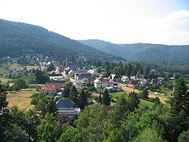 A general view of Wangenbourg | |
 Coat of arms | |
show Location of Wangenbourg-Engenthal | |
 Wangenbourg-Engenthal | |
| Coordinates: 48°38′N 7°18′E / 48.63°N 7.30°ECoordinates: 48°38′N 7°18′E / 48.63°N 7.30°E | |
| Country | France |
| Region | Grand Est |
| Department | Bas-Rhin |
| Arrondissement | Molsheim |
| Canton | Saverne |
| Intercommunality | |
| Government | |
| • Mayor (2020–2026) | Daniel Acker[1] |
| Area 1 | 31.52 km2 (12.17 sq mi) |
| Population (Jan. 2018)[2] | 1,341 |
| • Density | 43/km2 (110/sq mi) |
| Time zone | UTC+01:00 (CET) |
| • Summer (DST) | UTC+02:00 (CEST) |
| INSEE/Postal code | 67122 /67710 |
| Elevation | 284–964 m (932–3,163 ft) (avg. 420 m or 1,380 ft) |
| 1 French Land Register data, which excludes lakes, ponds, glaciers > 1 km2 (0.386 sq mi or 247 acres) and river estuaries. | |


Wangenbourg-Engenthal (German: Wangenburg-Engenthal) is a commune in the Bas-Rhin department in Grand Est in north-eastern France.
The commune is not a single settlement, but rather an administrative unit comprising the following eight mountain hamlets:
- Engenthal-le-Bas
- Engenthal-le-Haut
- Freudeneck
- les Huttes
- Obersteigen
- Schneethal
- Windsbourg
- Wolfsthal
Population[]
| Year | Pop. | ±% |
|---|---|---|
| 2006 | 1,361 | — |
| 2007 | 1,366 | +0.4% |
| 2008 | 1,383 | +1.2% |
| 2009 | 1,376 | −0.5% |
| 2010 | 1,369 | −0.5% |
| 2011 | 1,362 | −0.5% |
| 2012 | 1,365 | +0.2% |
| 2013 | 1,370 | +0.4% |
| 2014 | 1,370 | +0.0% |
| 2015 | 1,369 | −0.1% |
| 2016 | 1,368 | −0.1% |
See also[]
References[]
- ^ "Répertoire national des élus: les maires". data.gouv.fr, Plateforme ouverte des données publiques françaises (in French). 2 December 2020.
- ^ "Populations légales 2018". INSEE. 28 December 2020.
| Wikimedia Commons has media related to Wangenbourg-Engenthal. |
| show Authority control |
|---|
This Bas-Rhin geographical article is a stub. You can help Wikipedia by . |
Categories:
- Communes of Bas-Rhin
- Bas-Rhin geography stubs