Watts, Los Angeles
Watts | |
|---|---|
Neighborhood of Los Angeles | |
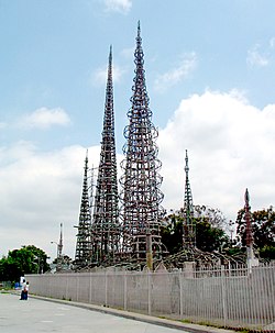 The Watts Towers, created by Simon Rodia | |
 Watts Location of Watts, Los Angeles | |
| Coordinates: 33°56′30″N 118°14′30″W / 33.94167°N 118.24167°W | |
| Country | United States |
| State | California |
| County | Los Angeles |
| City | Los Angeles |
| Government | |
| • City Council | Joe Buscaino |
| • State Assembly | Mike Gipson (D) |
| • State Senate | Roderick Wright (D) |
| • U.S. House | Nanette Barragán (D) |
| Area | |
| • Total | 2.0 sq mi (5 km2) |
| Population (2000)[1] | |
| • Total | 34,830 |
| • Density | 17,350/sq mi (6,700/km2) |
| ZIP Code | 90002 |
| Area code(s) | 323 |
| Website | Watts Neighborhood Council |


Watts is a neighborhood in southern Los Angeles, California. It is located within the South Los Angeles region, bordering the cities of Lynwood and South Gate to the east and southeast, respectively, and the unincorporated community of Willowbrook to the south.
Founded in the late nineteenth century as a ranching community, the arrival of the railroads and the construction of Watts Station saw the rapid development of Watts as an independent city, but in 1926 it was consolidated with Los Angeles. By the 1940s, Watts transformed into a primarily working class African-American neighborhood, but from the 1960s developed a reputation as a low-income, high-crime area, following the Watts riots and the increasing influence of street gangs.[2] Watts has become a predominantly Hispanic neighborhood with a significant African American minority,[3] and remains one of the most impoverished neighborhoods in Los Angeles despite falling crime rates since the 1990s. Notable civic activities by residents of Watts include the "Toys for Watts" toy drive, the Watts Christmas parade, and the "Watts Summer Games" athletic tournament, as well as a local theatre and a dance company, in an effort to improve the neighborhood.[4]
Watts is noted internationally for the landmark Watts Towers by Simon Rodia, which are a Los Angeles Historic-Cultural Monument and also listed on the National Register of Historic Places. The neighborhood has also been featured or referenced in numerous forms of media, particularly West Coast hip-hop music, and movies and television shows set in Los Angeles.
History[]

The area now known as Watts is located on the 1843 Rancho La Tajauta Mexican land grant. As on all ranchos, the principal vocation at that time was grazing and beef production.[5]
With the influx of European American settlers into Southern California in the 1870s, La Tajuata land was sold off and subdivided for smaller farms and homes, including a 220-acre (89 ha) parcel purchased by Charles H. Watts in 1886 for alfalfa and livestock farming. In those days each Tajuata farm had an artesian well.
The arrival of the railroad spurred the settlement and development of the area. Most of the first residents were the traqueros, Mexican and Mexican American rail workers who constructed and maintained the new rail lines.[6]
With this new growth, Watts was incorporated as a separate city, taking its name from the first railroad station, Watts Station that had been built in 1904 on 10 acres (4.0 ha) 10 acres of land donated by the Watts family. The city voted to merge with Los Angeles in 1926.[5]
Watts did not become predominantly black until the 1940s.[7] Before then, there were some African American residents, many of whom were Pullman car porters and cooks. Schoolroom photos from 1909 and 1911 show only two or three black faces among the 30 or so children pictured. By 1914, a black realtor, Charles C. Leake, was doing business in the area.[5] Racially restrictive covenants prevented blacks from living in any other neighborhoods outside of Central Avenue District and Watts.[8]
World War II brought the Second Great Migration, tens of thousands of African American migrants, mostly from Louisiana, Mississippi, Arkansas and Texas, who left segregated Southern states in search of better opportunities in California. During World War II, the city built several large housing projects (including Nickerson Gardens, Jordan Downs and Imperial Courts) for the thousands of new workers in war industries. By the early 1960s, these projects had become nearly 100 percent black, as whites moved on to new suburbs outside the central city. As industrial jobs disappeared from the area, the projects housed many more poor families than they had traditionally.
Longstanding resentment by Los Angeles's working class black community over discriminatory treatment by police and inadequate public services (especially schools and hospitals) exploded on August 11, 1965, into what were commonly known as the Watts riots.[3] The event that precipitated the disturbances, the arrest of a black youth by the California Highway Patrol on drunk-driving charges, actually occurred outside Watts.
Watts suffered further in the 1970s, as gangs gained strength and raised the level of violence in the neighborhood. Between 1989 and 2005, police reported more than 500 homicides in Watts, most of them gang-related and tied to wars over control of the lucrative illicit market created by illegal drugs. Four of Watts's influential gangs— Watts Cirkle City Piru, Grape Street Watts Crips, Bounty Hunter Watts Bloods, and PJ Watts Crips—formed a Peace Treaty agreement, known as the Watts truce on April 26, 1992.[9] Key hallmarks of the pact continue to influence life in Watts to date, with colors and territory having little to do with gang-related crime.
Beginning in the 1980s, those African Americans who could leave Watts moved to other suburban locations in the Antelope Valley, the Inland Empire, the San Gabriel Valley, Orange County and the San Joaquin Valley. The black population in Watts has been increasingly replaced by other demographic groups, primarily Hispanic immigrants of Mexican and Central American ancestry, as well as by a median proportion of Ethiopian and Indian ancestry. This demographic change accelerated after the 1992 riots.[citation needed]
Neighborhood leaders have begun a strategy to overcome Watts's reputation as a violence-prone and impoverished area. Special promotion has been given to the museums and art galleries in the area surrounding Watts Towers. This sculptural and architectural landmark has attracted many artists and professionals to the area. I Build the Tower, a feature-length documentary film about the Watts Towers and their creator, Simon Rodia, provides a history of Watts from the 1920s to the present and a record of the activities of the Watts Towers Arts Center. Watts is one of several Los Angeles neighborhoods with a high concentration of convicted felons.[10] In 2000, singer and actor Tyrese Gibson chartered a foundation to build a community center in Watts.[11]
In 2019, the Watts Towers were a gathering place along the 25.5-mile (41.0 km) funeral procession from the memorial for Nipsey Hussle at the Staples Center that wound through the streets of South L.A.[12] At times, the crowd flooded the street creating gridlock.[13]
Geography[]
The Mapping L.A. project of the Los Angeles Times states as follows:
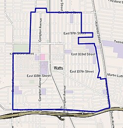
The neighborhood's irregular street boundaries follow the Los Angeles city limits on the north and east, except for a small patch of Los Angeles County territory surrounding Ritter Elementary School, between 108th Street and Imperial Highway, which the Times includes in Watts.[14][15]
The southern boundary runs east-west on Imperial Highway, the eastern line is north-south on Alameda Street and the western line is north-south on Central Avenue to 103rd Street. Ted Watkins Park and other county areas are excluded. Thence the line is Success Avenue between Century Boulevard and 92nd Street.[14][15]
Watts is flanked on the north by Florence-Firestone, on the east by South Gate, on the southeast by Lynwood, on the south by Willowbrook and on the north and west by Green Meadows.[14]
Climate[]
| hideClimate data for Watts, Los Angeles | |||||||||||||
|---|---|---|---|---|---|---|---|---|---|---|---|---|---|
| Month | Jan | Feb | Mar | Apr | May | Jun | Jul | Aug | Sep | Oct | Nov | Dec | Year |
| Record high °F (°C) | 91 (33) |
92 (33) |
93 (34) |
105 (41) |
102 (39) |
110 (43) |
107 (42) |
104 (40) |
111 (44) |
106 (41) |
100 (38) |
91 (33) |
111 (44) |
| Average high °F (°C) | 68 (20) |
69 (21) |
69 (21) |
72 (22) |
74 (23) |
78 (26) |
82 (28) |
83 (28) |
82 (28) |
78 (26) |
73 (23) |
68 (20) |
75 (24) |
| Average low °F (°C) | 47 (8) |
50 (10) |
51 (11) |
53 (12) |
57 (14) |
61 (16) |
64 (18) |
65 (18) |
64 (18) |
59 (15) |
52 (11) |
47 (8) |
56 (13) |
| Record low °F (°C) | 24 (−4) |
31 (−1) |
32 (0) |
37 (3) |
40 (4) |
43 (6) |
47 (8) |
46 (8) |
45 (7) |
40 (4) |
33 (1) |
30 (−1) |
24 (−4) |
| Average precipitation inches (mm) | 3.23 (82) |
3.56 (90) |
2.86 (73) |
0.71 (18) |
0.25 (6.4) |
0.08 (2.0) |
0.02 (0.51) |
0.14 (3.6) |
0.29 (7.4) |
0.40 (10) |
1.14 (29) |
1.86 (47) |
14.53 (369) |
| Source: [16][17][18] | |||||||||||||
Population[]
A total of 36,815 people lived in Watts's 2.12 square miles, according to the 2000 U.S. census—averaging 17,346 people per square mile, among the highest population densities in Los Angeles. Population was estimated at 41,028 in 2008. The median age was 21, making Watts the Los Angeles neighborhood with the youngest population. The percentages of residents aged birth to 18 were among the county's highest.[1][19]
Hispanics made up 61.6% of the population, blacks 37.1%, non-Hispanic whites 0.5%, Asian 0.2%, and others 0.5%. Mexico and El Salvador were the most common places of birth for the 34% of the residents who were born abroad, an average percentage of foreign-born when compared with the city or county as a whole.[1]
The $25,161 median household income in 2008 dollars was considered low for the city and county. The percentage of households earning $20,000 or less was high, compared to the county at large. The average household size of 4 people was high for the city. Renters occupied 67% of the housing units, and homeowners occupied the rest.[1]
In 2000, there were 2,816 families headed by single parents, or 38.9%, the highest rate for any neighborhood in the city.[20] The percentages of never-married women (45.3) and never-married men (44.7) were among the county's highest.[1]
In 2000, there were 739 military veterans, or 3.6% of the population, low when compared to the rest of the city.[1]
Government and infrastructure[]

Local government[]
Watts Neighborhood Council 10221 Compton Avenue, Suite 106A, LA CA 90002.
Los Angeles Fire Department Station 65[21] (Watts) serves the community.
Los Angeles County Fire Department Station 16[22] (Watts) serves the community.
Los Angeles Police Department operates the nearby Southeast Community Police Station.[23]
County, state and federal representations[]
The Los Angeles County Department of Health Services operates the South Health Center in Watts.[24]
The California Department of Corrections and Rehabilitation operates the L.A. Watts Juvenile Parole Center.[25]
The United States Postal Service Augustus F. Hawkins Post Office is located at 10301 Compton Avenue.[26] On January 24, 2000 the United States House of Representatives and the United States Senate presented a bill to rename the Watts Finance Office as the Hawkins Post Office.[27]
Education[]
Just 2.9% of Watts residents aged 25 and older had earned a four-year degree, according to the 2000 census, which is considered a low figure for both the city and the county. The percentage of those residents with less than a high school diploma was high in comparison with the county at large.[1]
Schools[]
Schools within Watts are as follows:[15][28]
- David Starr Jordan Senior High School, LAUSD, 2265 East 103rd Street
- Animo College Prep Academy, Green Dot Public Schools, 2265 East 103rd Street [2]
- Thomas Riley High School, LAUSD alternative, 1524 East 103rd Street
- Alliance Cindy & Bill Simon Technology High School, charter school, 10720 South Wilmington Avenue
- Verbum Dei High School, private, 11100 South Central Avenue
- Simon Rodia Continuation School, LAUSD, 2315 East 103rd Street
- Edwin Markham Middle School, LAUSD, 1650 East 104th Street
- Ninety-Sixth Street Elementary School, LAUSD, 1471 East 96th Street
- St. Lawrence of Brindisi Elementary School, 10044 Compton Avenue
- Weigand Avenue Elementary School, LAUSD, 10401 Weigand Avenue
- Dorothy V. Johnson Community Day School, LAUSD, 10601 South Grandee Avenue
- San Miguel Catholic School, private elementary, 2270 East 108th Street
- Lovelia P. Flournoy Elementary School, LAUSD, 1630 East 111th Street
- Grape Street Elementary School, LAUSD, 1940 East 111th Street
- Ritter Elementary School, LAUSD, 11108 Watts Avenue
- Ninety-Second Street Elementary School, LAUSD, 9211 Grape Street
- Alain Leroy Locke College Preparatory Academy, Green Dot Public Schools grades 9-12, 325 East 111th Street
- Compton Avenue Elementary School, 1515 East 104th Street
- Resolute Academy Charter School, E 112th St, Los Angeles, CA 90059
King Drew Magnet High School of Medicine and Science opened in bungalows of Jordan in 1982.[29] In 1999 it moved to a standalone campus in Willowbrook.[30]
In May 2013 Wiegand Avenue Elementary School became the first school in California from which a principal was ordered removed in response to the state's 2010 "trigger law," which compels the dismissal of a school administrator on petition of a majority of parents. As a result of the pending loss of principal Irma Cobian, 21 of 22 teachers asked for transfer to other schools.[31]
Public libraries[]
Los Angeles Public Library operates the Alma Reaves Woods – Watts Branch.[32]
Watts received its first library service in 1913 when temporary space was designated in the city hall for a library. In 1914 the library moved into a newly built Carnegie library. Los Angeles annexed Watts in 1926, so the library became the Watts Branch of the Los Angeles library system. In 1957 voters approved a library branch bond, and a 3,600 square feet (330 m2) Watts Branch opened in 1960. In 1991 the Los Angeles City Council approved a measure, backed by the Friends of the Watts Branch Library, the 15th District Council Office, and the Community Redevelopment Agency (CRA) of the City of Los Angeles, to build a new library as a part of the 1.3 acres (0.53 ha) Watts Civic Center. $1.3 million from Proposition 1, the branch library facility bond issue of 1989, funded the construction of the new Watts library. On June 25, 1996 the city council voted to name the library after Alma Reaves Woods, a woman in the community who encouraged reading and library usage.[33] James C. Moore, AIA & Associates designed the current Watts Library, which opened on June 29, 1996.[34]
Community service[]
CicLAvia Tour[]
On January 22, 2012, the popular cycling event called CicLAvia took place in south L.A.'s Central-Alameda neighborhood to the Watts Towers. Volunteers were excited to hold an event close to the CicLAvia events in downtown L.A. The event was meant to encourage civic engagement. Throughout the group of volunteers the diversity was large. Cyclists took photos for a "crowd-source" map made up of photos and recordings by the cyclists.[35]
Watts Re-Imagined[]
Watts Re:Imagined[36] is a local urban planning initiative led by Grant Housing Economic Development Corps (Grant EDC, a non-profit division of the community-based Grant AME church) and the Natural Resources Defense Council (NRDC[37]) Urban Solutions program. Its mission is to help the community of Watts realize their full potential by promoting economic opportunity, social equity, public health, and an improved quality of life, all while working with community leaders to preserve the identity of the area. It is trying to achieve this goal by implementing different existing plans proposed for the area. The Watts Re:Imagined initiative was formed in response to the dissolution of the Community Redevelopment Agency of Los Angeles.[38]
Parks and recreation[]
The following recreation facilities are within the Watts boundaries:
- Watts Senior Citizen Center, 1657 East Century Boulevard[15][39]
- 109th Street Recreation Center, 1464 East 109th Street. The center, which acts as a Los Angeles Police Department stop-in center, has an auditorium, a lighted baseball diamond, lighted indoor and outdoor basketball courts, a children's play area, a lighted football field, an indoor gymnasium with weights, an outdoor gymnasium without weights, a lighted soccer field, and lighted tennis courts.[15][40] The 109th Street Pool is a seasonal outdoor unheated pool.[41] In June 2008, a group of young men attacked a manager there, forcing the city to close the pool for a short period of time. When it re-opened, police were stationed there.[42] The pool, located between the Nickerson Gardens and Jordan Downs public housing complexes, also lay between two competing gangs in 2008.[43]
- Unnamed Park, Evers Street[15]
Attractions[]
Watts Towers[]
The Watts Towers or Towers of Simon Rodia is a collection of 17 interconnected structures, two of which reach heights of over 99 feet (30 m). The Towers were built by Italian immigrant construction worker Sabato ("Sam" or "Simon") Rodia in his spare time over a period of 33 years, from 1921 to 1954. The work is an example of non-traditional vernacular architecture and American Naïve art.[44][45]
Watts Station[]
The Watts station was a train station built in 1904. It is a National Historic Landmark.[46] It has been known as one of the few structures that were untouched by a huge fire along 103rd Street stores during the 1965 Watts riots. When it was found intact, it was a symbol of hope and faith for the Watts community. Being one of the most original buildings that was first constructed in Watts, it was a popular stop for the Pacific Electric Railway's "Red Car" that ran through Los Angeles, CA, to Long Beach, CA, for 50 years. It was also admitted to the NRHP (National Register of Historic Places) four months after the riots.
Watts Christmas Parade[]
The Watts Christmas parade was created in 1964 by Edna Aliewine before the Watts riots. She put together a group of local volunteers to fundraise and create the parade. Ms. Aliewine started a drill team with neighborhood girls which marched in homemade Santa hats. She died at the age of 90 in her home in Watts on July 5, 2011.[47][48]
Watts Summer Games[]
The L.A. Watts Summer Games started in 1968 and were held at Locke High School. The games are a three-day athletic tournament that brings together more than 5,000 students from 200 California schools. Almost 200,000 youth have competed in the games over the past 30 years. The Watts Summer Games have a scholarship program for students who are dedicated to the community and have awarded more than $300,000 since their inception in 1992.[49][50]
Performing arts[]
Dance[]
Epifani Dance Company was founded by Lakesha Buchanon in Watts in 2002.[51] They compete in year-round SHARP International competitions, where they have won several first-place trophies.
Theater[]
Located on 107th Street, the Watts Village Theater Company is a multicultural urban company whose mission is to "inspire its community with an appreciation of all cultures." The company was started in 1996 and has been involved in helping the community with educational workshops ever since. The members strive to make a more understanding Watts whose citizens can harmoniously live together in a diverse community.[52]
Newspapers[]
- LA Youth was founded by Donna Myrow in 1988. The first edition of the publication sold 2,500 copies. Its current circulation is 120,000. LA Youth reaches approximately half a million readers.[53]
- L.A. Watts Times Weekender Newspaper is an African American newspaper in both print form and online. It was started in 1965 with the motto: "The Voice of Our Community Speaking for Itself."[54]
- In the summer of 2010 the Bakewell family was in negotiation to purchase the LA Watts Times.[55] Danny Bakewell said, "I am proud and honored that Melanie chose me and my family to continue the great legacy of the Watts Times, its founders and her parents,".[55]
In popular culture[]
Music[]
Watts, along with several other California areas, is referenced in the hip-hop songs "California Love" by 2Pac featuring Dr. Dre & Roger Troutman, and "Creep N Crawl" by Eazy E.
For five years, the record label Top Dawg Entertainment has hosted a Christmas benefit concert in the Nickerson Gardens Housing Projects. The free concert draws tens of thousands of attendees and includes performances from TDE artists SZA, Kendrick Lamar, and Jay Rock who was raised in the Nickerson Gardens Housing Projects.[56][57]
Television and film[]
- The television series Sanford and Son, was set in Watts, and the neighborhood was mentioned prominently by the characters.[58][59][60]
- The television series Two and a Half Men had an episode called "Weekend in Bangkok with Two Olympic Gymnasts",[61] which makes reference to Watts in a brief scene. The show also features a restaurant called “Clucky's” located in Watts in the same episode.
- A plot in the film The Big Lebowski involves the embezzlement of a million dollars from a foundation that ensures a college education for youngsters from Watts, the so-called Little Lebowski Urban Achievers.
- The film Menace II Society was filmed at the Jordan Downs public housing project in Watts.
- Charles Burnett's Killer of Sheep was filmed in and is set in Watts in the early 1970s.
- Wassup Rockers was filmed in Watts, and parts were filmed at Locke High School and Gompers Middle School.[62]
- Portions of the Oscar award-winning movie Training Day were filmed in and around the Imperial Courts public housing project in Watts.
- The television series What's Happening!! and its sequel What's Happening Now!! was set in Watts, where the characters lived.
- The reality television series Pit Boss (Season 1) filmed an episode when Shorty Rossi returned to his community to do a fundraiser for the kids of Nickerson Gardens public housing project in Watts.
Notable people[]
- 03 Greedo, rapper[63]
- P. P. Arnold, singer[64]
- Bambu, rapper
- Arna Bontemps, poet and novelist of the Harlem Renaissance
- Don Cherry, jazz musician
- Dr. Dre, rapper, record producer, and entrepreneur[65]
- Robert C. Farrell (born 1936), journalist and member of the Los Angeles City Council, 1974–91; Watts newspaper publisher
- Shawn Fonteno (actor)
- Nipsey Hussle, Rapper, activist, and entrepreneur
- Tyrese Gibson, R&B singer and actor
- Florence Griffith-Joyner, Olympic track and field gold medalist; raised in the Jordan Downs projects[66]
- "Sweet Alice" Harris, community organizer; founder and executive director of local youth outreach group Parents of Watts[67]
- Etta James, singer[68]
- Glasses Malone, rapper; born in Watts
- Charles Mingus, jazz musician, composer, bandleader, and civil rights activist; raised largely in the Watts area[69]
- Walter Mosley, novelist
- Anthony Ortega jazz saxophonist, Smithsonian Honoree, cousin of Ray Vasquez
- Jerron "Blind Boy" Paxton, musician, vocalist and multi-instrumentalist
- Jay Rock, rapper[70]
- Shorty Rossi, reality television star
- Sylvester, disco singer
- Glenn T. Seaborg, chemist, Nobel Prize winner in chemistry[71]
- Ray Vasquez Singer, Trombonist, Actor, Jordan High School Watts
- The Watts Prophets, hip-hop/jazz and poetry group
- The Sylvers, family R&B/disco/pop group
Transportation[]
Public transportation[]
Watts is served by the 103rd Street/Watts Towers A Line station.
Historically, the neighborhood was served by the Pacific Electric Watts Station and several Pacific Electric lines, including the Watts Line.
See also[]
References[]
- ^ Jump up to: a b c d e f g h "Mapping L.A.: "Watts"". Los Angeles Times. Retrieved March 30, 2010.
- ^ "Watts". Mapping L.A.
- ^ Jump up to: a b Melley, Brian (August 10, 2020). "55 years after riots, Watts section of LA still bears scars". AP NEWS. Retrieved August 12, 2020.
- ^ Shaver, Shonassee (February 27, 2014). "The Beautiful Color of Watts; Lynn Manning's gift for theatre thrives at the Watts Village Theater Company". L.A. Watts Times. Retrieved November 6, 2015.
- ^ Jump up to: a b c Ray, MaryEllen Bell (1985). The City of Watts, California: 1907 to 1926. Los Angeles: Rising Publications.
- ^ Romo, Ricardo (1983). East Los Angeles: A History of a Barrio. University of Texas Press. p. 69.
- ^ Rothstein, Richard (August 20, 2017). "Why Los Angeles is still a segregated city after all these years". LA Times. Retrieved August 20, 2017.
- ^ Bauman, Robert (2008). Race and the War on Poverty: From Watts to East L.A. University of Oklahoma Press : Norman.
- ^ Chang, Jeff (April 1, 2007). Can't Stop Won't Stop: A History of the Hip-Hop Generation. St. Martin's Press. p. 365. ISBN 978-1-4299-0269-4. Retrieved November 6, 2015.
- ^ "Library of Congress Web Archives". Los Angeles Times. Archived from the original on October 6, 2012.
- ^ Fuoco, Christina (June 23, 2006). "Tyrese Biography". Musician Biographies. Retrieved December 14, 2008.
- ^ Wick, Julia (April 11, 2019). "An altar of love blooms for Nipsey Hussle in the shadow of the Watts Towers". Los Angeles Times. Retrieved April 12, 2019.
- ^ Jennings, Angel. "Tens of thousands mourn Nipsey Hussle. But his memorial service was all about South L.A." Los Angeles Times. Retrieved April 12, 2019.
- ^ Jump up to: a b c "Mapping L.A.: "South L.A."". Los Angeles Times. 2015. Retrieved November 6, 2015.
- ^ Jump up to: a b c d e f Thomas Guide. 2006. p. 704.
- ^ "Zipcode 90002". www.plantmaps.com. Retrieved March 14, 2021.
- ^ "Watts, CA Climate". www.myforecast.co. Retrieved March 14, 2021.
- ^ "Culver City, California Travel Weather Averages". www.weatherbase.com. Retrieved March 31, 2021.
- ^ "Mapping L.A.: Median Age Ranking". Los Angeles Times. 2015. Retrieved November 6, 2015.
- ^ "Mapping L.A.: Single Parents Ranking". Los Angeles Times. 2015. Retrieved November 6, 2015.
- ^ "Station 65 - Los Angeles Fire Department". www.lafd.org.
- ^ "Station 16".
- ^ "Southeast Community Police Station". Los Angeles Police Department. Retrieved May 4, 2009.
- ^ "South Health Center" (PDF). Los Angeles County Department of Health Services. Retrieved March 18, 2010.
- ^ "Southern Region Division of Juvenile Parole Operations". California Department of Corrections and Rehabilitation. Retrieved May 25, 2010.
- ^ "Post Office Location - AUGUSTUS F. HAWKINS". United States Postal Service. Retrieved November 6, 2015.
- ^ "H.R. 643: To redesignate the Federal building located at 10301 South Compton Avenue, in Los Angeles, California". THOMAS. Library of Congress. 2015. Archived from the original on January 6, 2016. Retrieved November 6, 2015.
- ^ "Mapping L.A.: Watts Schools". Los Angeles Times. 2015. Retrieved November 6, 2015.
- ^ Landsberg, Mitchell (April 27, 2005). "This King/Drew, a Magnet School, Is a Robust Success". Los Angeles Times. p. 1. Retrieved April 16, 2014.
- ^ Landsberg, Mitchell (April 27, 2005). "This King/Drew, a Magnet School, Is a Robust Success". Los Angeles Times. p. 2. Retrieved April 16, 2014.
- ^ Watanabe, Teresa (May 24, 2013). "Popular Principal's Dismissal Leaves a South L.A. School Divided". Los Angeles Times.
- ^ "Alma Reaves Woods - Watts Branch Library". Los Angeles Public Library. Retrieved March 28, 2010.
- ^ WILGOREN, JODI (June 26, 1996). "Council Lifts Policy, Names Watts Library for Volunteer". LA Times. Retrieved April 2, 2018.
- ^ "A Brief Watts Branch Library History". Los Angeles Public Library. Retrieved March 28, 2010.
- ^ Song, Jason (January 22, 2012). "Bicyclists tour Watts on a CicLAvia ride". Los Angeles Times.
- ^ "Watts Re:Imagined - People - Place - Possibility". wattsreimagined.org.
- ^ "NRDC". NRDC.
- ^ staff writer (May 21, 2015). "Watts ReImagined 50 Years After the Riots". Our Weekly Los Angeles.
- ^ "Watts Senior Citizen Center". City of Los Angeles Department of Recreation and Parks. 2014. Archived from the original on January 25, 2016. Retrieved November 6, 2015.
- ^ "109th Street Recreation Center". City of Los Angeles Department of Recreation and Parks. 2014. Retrieved November 6, 2015.
- ^ "109th Street Pool". City of Los Angeles Department of Recreation and Parks. 2015. Archived from the original on October 19, 2015. Retrieved November 6, 2015.
- ^ Mitchell, John L. (June 26, 2008). "Watts pool reopens with tighter security". Los Angeles Times. Retrieved November 6, 2015.
- ^ Mitchell, John L. (June 24, 2008). "Watts pool drowned in violence". Los Angeles Times. Retrieved November 6, 2015.
- ^ "Watts Towers". National Historic Landmark summary listing. National Park Service. September 18, 2007.
- ^ Goldstone, Arloa Paquin (June 18, 1990). "The Towers of Simon Rodia". National Register of Historic Places Registration. National Park Service.
- ^ "Watts Metro Adventure". ExperienceLA.com. Retrieved November 6, 2015.
- ^ Landsberg, Mitchell (December 5, 2010). "Thousands turn out for Watts/Willowbrook Christmas Parade". Los Angeles Times.
- ^ "Edna Aliewine, a giant has fallen". LA Sentinel. July 7, 2011. Retrieved October 14, 2012.
- ^ "The Los Angeles Watts Summer Games are back!". LA Sentinel. May 25, 2011. Retrieved October 14, 2012.
- ^ "Watts Summer Games 2011". Supervisor Mark Ridley-Thomas. June 13, 2011. Retrieved November 6, 2015.
- ^ "Epifani Dance Company". epifanidancecompany.org. 2015. Archived from the original on July 3, 2011. Retrieved November 6, 2015.
- ^ "WVTC Serving Its Community". Watts Village Theater Company. Retrieved October 14, 2012.
- ^ "Youth Newspaper Gives Los Angeles Teens a Voice". Voanews.com. October 27, 2009. Retrieved October 14, 2012.
- ^ "Home". LA Watts Times. Retrieved November 6, 2015.
- ^ Jump up to: a b Brooks, Brandon I. (June 10, 2010). "Bakewell Family to Purchase LA Watts Times". New America Media. Retrieved October 14, 2012.
- ^ "Jay Rock | Biography & History". AllMusic. Retrieved September 17, 2019.
- ^ "Top Dawg Entertainment's Christmas party in Watts was equally reflective and celebratory". Los Angeles Times. December 20, 2018. Retrieved September 17, 2019.
- ^ ""Sanford and Son" Watts Side Story (TV Episode 1973)". IMDb. Retrieved November 6, 2015.
- ^ ""Sanford and Son" Greatest Show in Watts (TV Episode 1976)". IMDb. Retrieved November 6, 2015.
- ^ "Sanford and Son and El Segundo". City-Data Forum. Retrieved November 6, 2015.
- ^ ""Two and a Half Men" Weekend in Bangkok with Two Olympic Gymnasts - September 19, 2005 (TV Episode 2005)". IMDb. September 19, 2005. Retrieved February 14, 2017.
- ^ "Wassup Rockers (2005)". IMDb. April 5, 2006. Retrieved November 6, 2015.
- ^ "The Impossible Tale of 03 Greedo, the Future of West Coast Rap". Noisey. January 16, 2018. Retrieved April 23, 2018.
- ^ [1] Christian John Wikane, “Suvival and Serendipitry: An Interview With Norther Soul Legend P.P. Arnold,” ‘’PopMatters,’’ August 8, 2019
- ^ Ben Westhoff: Original Gangstas: Tupac Shakur, Dr. Dre, Eazy-E, Ice Cube, and the Birth of West Coast Rap. Hachette UK.
- ^ "A Community Remembers FloJo". Los Angeles Times. September 23, 1998. p. B-8. Retrieved December 8, 2008.
- ^ Armstrong, Robin (2006). "Alice Harris". Contemporary Black Biography. Gale. Retrieved December 2, 2008.
- ^ Gulla, Bob (2008). Icons of R&B and Soul. Greenwood Press. p. 149. ISBN 978-0-313-34045-1. Retrieved November 6, 2015.
- ^ Santoro, Gene (1994). Myself When I am Real: The Life and Music of Charles Mingus. Oxford University Press. ISBN 0-19-509733-5.
- ^ Jeffries, David. "Jay Rock". Billboard.
- ^ Seaborg, G. T.; Seaborg, E. (2001). Adventures in the Atomic Age: From Watts to Washington. Farrar, Straus and Giroux. ISBN 0-374-29991-9.

|
Florence-Graham, California | Walnut Park, California |
| ||||
| South Los Angeles | South Gate, California | ||||||
| Athens, California | Willowbrook, California | Lynwood, California |
External links[]
 Media related to Watts, Los Angeles at Wikimedia Commons
- Watts crime map and statistics
- Image of a woman and baby on the sidewalk in Watts, Los Angeles, California, 1965. Los Angeles Times Photographic Archive (Collection 1429). UCLA Library Special Collections, Charles E. Young Research Library, University of California, Los Angeles.
Coordinates: 33°56′30″N 118°14′30″W / 33.94167°N 118.24167°W
| show South Los Angeles region, Los Angeles |
|---|

| show |
|---|

| show Authority control |
|---|
- Watts, Los Angeles
- Former municipalities in California
- Neighborhoods in Los Angeles
- South Los Angeles
- African-American history in Los Angeles
- Populated places established in 1907
- 1926 disestablishments in California
- Chicano and Mexican neighborhoods in California