Xingtai County
This article needs to be updated. The reason given is: On June 23 2020 The State Council have approved the annexation of Xingtai County into Xiangdu and Xindu Districts. (June 2020) |
Xingtai County
邢台县 | |
|---|---|
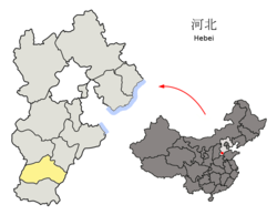
 Xingtai County in Xingtai City | |
 Xingtai City in Hebei | |
| Coordinates: 37°7′N 114°34′E / 37.117°N 114.567°ECoordinates: 37°7′N 114°34′E / 37.117°N 114.567°E | |
| Country | People's Republic of China |
| Province | Hebei |
| Prefecture-level city | Xingtai |
| Area | |
| • Total | 1,983 km2 (766 sq mi) |
| Elevation | 60 m (197 ft) |
| Population | |
| • Total | 450,000 |
| • Density | 230/km2 (590/sq mi) |
| Time zone | UTC+8 (China Standard) |
| Postal code | 054001 |

Xingtai County (simplified Chinese: 邢台县; traditional Chinese: 刑台縣 or 邢臺縣; pinyin: Xíngtái Xiàn) was a former county administered by the prefecture-level city of the same name, in the southwest of Hebei province, China, bordering Shanxi province to the west. It surrounds the two core districts of Xingtai on all sides except the south, though its seat of government is located in neighbouring Qiaodong District. The county has a population of 450,000[when?] residing in an area of 1,983 km2 (766 sq mi). It's now split between Xindu and Xiangdu districts.
Administrative divisions[]
The county administers 1 subdistrict, 13 towns, and 6 townships.[1]
Subdistricts:
- (豫让桥街道)
|
Towns:
|
Townships:
|
References[]
- ^ 2011年统计用区划代码和城乡划分代码:邢台县 (in Chinese). National Bureau of Statistics of the People's Republic of China. Archived from the original on July 10, 2012. Retrieved 2012-07-21.
External links[]
This Xingtai location article is a stub. You can help Wikipedia by . |
Categories:
- County-level divisions of Hebei
- Hebei geography stubs