Yūbetsu River
| Yūbetsu River 湧別川 | |
|---|---|
 | |
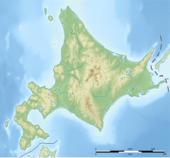 Location of the mouth | |
| Native name | Yūbetsu-gawa |
| Location | |
| Country | Japan |
| State | Hokkaidō |
| Region | Abashiri |
| District | Monbetsu |
| Municipalities | Engaru, Kamiyūbetsu, Yūbetsu |
| Physical characteristics | |
| Source | |
| • location | Engaru, Hokkaidō, Japan |
| • coordinates | 43°49′2″N 143°3′38″E / 43.81722°N 143.06056°E |
| • elevation | 1,553 m (5,095 ft) |
| Mouth | Sea of Okhotsk |
• location | Yūbetsu, Hokkaidō, Japan |
• coordinates | 44°13′56″N 143°37′16″E / 44.23222°N 143.62111°ECoordinates: 44°13′56″N 143°37′16″E / 44.23222°N 143.62111°E |
• elevation | 0 m (0 ft) |
| Length | 87 km (54 mi) |
| Basin size | 1,480 km2 (570 sq mi) |
| Discharge | |
| • average | 33.56 m3/s (1,185 cu ft/s) |

Yūbetsu River (湧別川, Yūbetsu-gawa) is a river in Hokkaidō, Japan.
As of 2005, some 34,000 people live in its watershed of 1,480 square kilometres (570 sq mi).[1]
Course[]
Yūbetsu River rises in the Kitami Mountains on the slopes of Mount Tengu.[1] The river travels some 87 kilometres (54 mi) to the Sea of Okhotsk.[1]
References[]
- ^ Jump up to: a b c 湧別川 (in Japanese). Ministry of Land,Infrastructure and Transport and Tourism Hokkaido Regional Development Bureau. Retrieved 2009-06-17.
| show |
|---|
| show Authority control |
|---|
This Hokkaidō location article is a stub. You can help Wikipedia by . |
This article related to a river in Japan is a stub. You can help Wikipedia by . |
Categories:
- Rivers of Hokkaido
- Rivers of Japan
- Hokkaidō geography stubs
- Japan river stubs