Úterý
Úterý | |
|---|---|
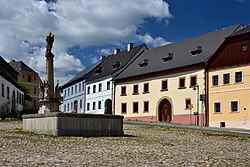 Town square | |
 Coat of arms | |
 Úterý Location in the Czech Republic | |
| Coordinates: 49°56′26″N 13°0′9″E / 49.94056°N 13.00250°ECoordinates: 49°56′26″N 13°0′9″E / 49.94056°N 13.00250°E | |
| Country | |
| Region | Plzeň |
| District | Plzeň-North |
| First mentioned | 1233 |
| Government | |
| • Mayor | Václav Konstantinovič |
| Area | |
| • Total | 25.92 km2 (10.01 sq mi) |
| Elevation | 485 m (1,591 ft) |
| Population (2021-01-01)[1] | |
| • Total | 463 |
| • Density | 18/km2 (46/sq mi) |
| Time zone | UTC+1 (CET) |
| • Summer (DST) | UTC+2 (CEST) |
| Postal code | 330 40 |
| Website | www |

Úterý (German: Neumarkt) is a small town in Plzeň-North District in the Plzeň Region of the Czech Republic. It has about 500 inhabitants and is one of the least populated municipalities with the town status in the country. The town centre is well preserved and is protected by law as an urban monument zone. Almost half of houses in Úterý are recreational objects.[2]
Administrative parts[]
Villages of Olešovice and Vidžín are administrative parts of Úterý.
Etymology[]
The town is popular for its name, which literally means "Tuesday".
History[]
The town was probably founded in 11th century, however the first written mention is from 1233.[2]
References[]
- ^ "Population of Municipalities – 1 January 2021". Czech Statistical Office. 2021-04-30.
- ^ Jump up to: a b "Město Úterý - Historie". Město Úterý. Retrieved 2019-08-12.
External links[]
| Wikimedia Commons has media related to Úterý. |
| show Authority control |
|---|
This Plzeň Region location article is a stub. You can help Wikipedia by . |
Categories:
- Cities and towns in the Czech Republic
- Populated places in Plzeň-North District
- Plzeň Region geography stubs