Tatiná
Tatiná | |
|---|---|
Municipality | |
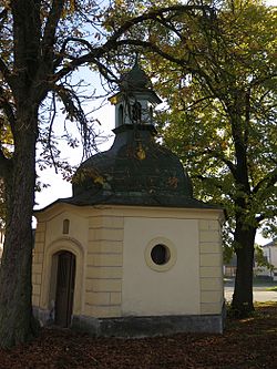 Chapel | |
 Flag  Coat of arms | |
 Tatiná | |
| Coordinates: 49°51′13″N 13°17′49″E / 49.85361°N 13.29694°ECoordinates: 49°51′13″N 13°17′49″E / 49.85361°N 13.29694°E | |
| Country | |
| Region | Plzeň |
| District | Plzeň-North |
| Area | |
| • Total | 4.39 km2 (1.69 sq mi) |
| Elevation | 437 m (1,434 ft) |
| Population (2010) | |
| • Total | 231 |
| • Density | 53/km2 (140/sq mi) |
| Postal code | 330 14 |
| Website | http://www.tatina.cz |

Tatiná is a village and municipality (obec) in Plzeň-North District in the Plzeň Region of the Czech Republic.
The municipality covers an area of 4.39 square kilometres (1.69 sq mi), and has a population of 248 (as at 3 July 2006).
Tatiná lies approximately 13 kilometres (8 mi) north-west of Plzeň and 85 km (53 mi) west of Prague.
References[]
| Wikimedia Commons has media related to Tatiná. |
| Authority control: National libraries |
|---|
This Plzeň Region location article is a stub. You can help Wikipedia by . |
Categories:
- Villages in Plzeň-North District
- Plzeň Region geography stubs