Alpestre, Rio Grande do Sul
Alpestre | |
|---|---|
 Flag  Seal | |
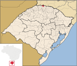 Location of Alpestre | |
| Coordinates: 27°14′56″S 53°02′06″W / 27.24889°S 53.03500°WCoordinates: 27°14′56″S 53°02′06″W / 27.24889°S 53.03500°W | |
| Country | Brazil |
| Region | South |
| State | Rio Grande do Sul |
| Founded | April 13, 1963 |
| Government | |
| • Mayor | Valdir Jose Zasso (PDT) |
| Area | |
| • Total | 328.749 km2 (126.931 sq mi) |
| Population (2020 [1]) | |
| • Total | 6,067 |
| Time zone | UTC-3 (UTC-3) |
| • Summer (DST) | UTC-2 (UTC-2) |
| HDI (2000) | 0.714 – medium[2] |

Alpestre is the northernmost municipality in the state of Rio Grande do Sul, Brazil. The city lies near the Uruguay River, at its northernmost point. A landmark called Ponto Extremo Norte (Extreme North Point) marks the northernmost point of the state.
References[]
- ^ IBGE 2020
- ^ "Archived copy". Archived from the original on 2009-10-03. Retrieved 2009-12-17.
{{cite web}}: CS1 maint: archived copy as title (link) - UNDP

 | This geographical article relating to Rio Grande do Sul is a stub. You can help Wikipedia by . |
Categories:
- Municipalities in Rio Grande do Sul
- Populated places established in 1963
- Rio Grande do Sul geography stubs