Tupanciretã
From Wikipedia, the free encyclopedia
Municipality in South, Brazil
Tupanciretã | |
|---|---|
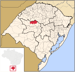
 Location in Rio Grande do Sul state | |
 Tupanciretã Location in Brazil | |
Coordinates:  29°4′50″S 53°50′9″W / 29.08056°S 53.83583°W / -29.08056; -53.83583Coordinates: 29°4′50″S 53°50′9″W / 29.08056°S 53.83583°W / -29.08056; -53.83583Coordinates:  29°4′50″S 53°50′9″W / 29.08056°S 53.83583°W / -29.08056; -53.83583 29°4′50″S 53°50′9″W / 29.08056°S 53.83583°W / -29.08056; -53.83583 | |
| Country | Brazil |
| Region | South |
| State | Rio Grande do Sul |
| Mesoregion | Centro Ocidental Rio-Grandense |
| Microregion | Santiago |
| Area | |
| • Total | 2,251.86 km2 (869.45 sq mi) |
| Elevation | 465 m (1,526 ft) |
| Population (2020 [1]) | |
| • Total | 24,068 |
| • Density | 11/km2 (28/sq mi) |
| Time zone | UTC-03:00 (BRT) |
| • Summer (DST) | UTC-02:00 (BRST) |
| Postal code | 98170-000 |
| Website | www |
Tupanciretã is a municipality of the western part of the state of Rio Grande do Sul, Brazil. The population is 24,068 (2020 est.) in an area of 2251.86 km².[2] Its elevation is 465 m. The name comes from the Tupi language. It is located west of the state capital of Porto Alegre and northeast of Alegrete.
Neighboring municipalities[]
- Cruz Alta
- Júlio de Castilhos
References[]
External links[]
- http://www.citybrazil.com.br/rs/tupancireta/ (in Portuguese)
- Anthem of the municipality of Tupanciretã
| Authority control |
|
|---|
 | This geographical article relating to Rio Grande do Sul is a stub. You can help Wikipedia by . |
- v
- t
Retrieved from ""
Categories:
- Municipalities in Rio Grande do Sul
- Rio Grande do Sul geography stubs
Hidden categories:
- Articles with short description
- Short description matches Wikidata
- Coordinates on Wikidata
- Articles with Portuguese-language sources (pt)
- Articles with VIAF identifiers
- Articles with WorldCat-VIAF identifiers
- All stub articles
