São Luiz Gonzaga
São Luiz Gonzaga | |
|---|---|
Municipality | |
 Flag  Coat of arms | |
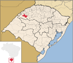 Location in Rio Grande do Sul state | |
 São Luiz Gonzaga Location in Brazil | |
| Coordinates: 28°24′28″S 54°57′39″W / 28.40778°S 54.96083°WCoordinates: 28°24′28″S 54°57′39″W / 28.40778°S 54.96083°W | |
| Country | |
| State | Rio Grande do Sul |
| Micro-region | Santo Ângelo |
| Area | |
| • Total | 1,295.68 km2 (500.26 sq mi) |
| Population (2020 [1]) | |
| • Total | 33,293 |
| • Density | 26/km2 (67/sq mi) |
| Time zone | UTC-3 (BRT) |
| • Summer (DST) | UTC-2 (BRST) |

São Luiz Gonzaga (Portuguese for St. Aloysius Gonzaga) is a municipality of the state of Rio Grande do Sul, Brazil. The population is 33,293 (2020 est.) in an area of 1295,68 km².[2] It was founded in the 17th century as a Jesuit mission town. It is located 503 km west of the state capital of Porto Alegre, northeast of Alegrete.
Bounding municipalities[]
- Roque Gonzales
- Rolador
- Caibaté
- São Miguel das Missões
- Bossoroca
- Santo Antônio das Missões
- São Nicolau
- Dezesseis de Novembro
References[]
External links[]
- http://www.citybrazil.com.br/rs/saoluizgonzaga/ (in Portuguese)
| show |
|---|

| Authority control |
|
|---|
 | This geographical article relating to Rio Grande do Sul is a stub. You can help Wikipedia by . |
Categories:
- Municipalities in Rio Grande do Sul
- Rio Grande do Sul geography stubs