Mato Leitão
Mato Leitão | |
|---|---|
Município/City | |
| Município de Mato Leitão | |
 Flag  Seal | |
| Nickname(s): Capital of Ochids | |
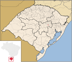 Location within Rio Grande do Sul | |
 Mato Leitão Location in the Brazil | |
| Coordinates: 29°31′32″S 52°07′36″W / 29.52567°S 52.126743°WCoordinates: 29°31′32″S 52°07′36″W / 29.52567°S 52.126743°W[1] | |
| Emancipação | March 20, 1992 |
| Government | |
| • Type | Mayor government |
| • Body | Prefeitura de Mato Leitão |
| • Prefeito(a) | , PP |
| Area | |
| • Total | 17.7 sq mi (46 km2) |
| Elevation | 266 ft (81 m) |
| Population | |
| • Total | 4,573 |
| • Density | 260/sq mi (100/km2) |
| • Urban | 1,621 |
| • Urbanization Rate (2010) | 41.9% |
| Demonym(s) | Matoleitoense |
| Time zone | UTC-3 (UTC-3) |
| • Summer (DST) | UTC-2 (UTC-2) |
| ZIP code(s) | 95835000 |
| Website | www |

Mato Leitão is a municipality in the state of Rio Grande do Sul, Brazil.
Geography[]
Mato Leitão is located at a latitude 29º31'28" south and a longitude 52º07'43" west, being at an altitude of 81 meters (266 feet).
It has an area of 45.9 km² (17.7 mi²) and a population of 3 869 inhabitants (2010).
In the main avenue of the city, Leopoldo A. Hinterholz Av., are located the cathedral, the prefecture, the and most of the local trade.
Culture and Economy[]
Known as the "Capital of the beautiful woman" and the "City of Orchids", Mato Leitão is a city of German colonization that has its economy based on agriculture - especially corn and tobacco - and food and footwear industry.
It's a peaceful place, where you can find typical German cookery and festivities. A curiosity is that there are many localities in Mato Leitão where people talk preferentially speak German to Portuguese.
Quality of Life[]
There are 4 schools in Mato Leitão, only 1 with High Schools' studies. However, Mato Leitão is considered as a reference in education, being in the top 15 at the state. Similarly, public health is a source of pride.
As an example, Mato Leitão has a 96.2% literacy rate and HDI of 0.746.
Also, Mato Leitão is a very safe place, where crimes like thefts and murders are extremely rare.
See also[]
- List of municipalities in Rio Grande do Sul
References[]
- ^ "US Gazetteer files: 2010, 2000, and 1990". United States Census Bureau. 2011-02-12. Retrieved 2011-04-23.
- ^ Mato Leitão, Prefeitura Municipal de (May 1, 2014). "Official Site". Mato Leitão, Prefeitura Municipal de. Retrieved May 1, 2014.
- ^ "US Board on Geographic Names". United States Geological Survey. 2007-10-25. Retrieved 2008-01-31.
- ^ IBGE 2020
External links[]
- FEEDADOS: http://feedados.fee.tche.br/
- Municipal Anthem: http://pt.wikisource.org/wiki/Hino_do_munic%C3%ADpio_de_Mato_Leit%C3%A3o

- Municipalities in Rio Grande do Sul