Amelia County, Virginia
Amelia County | |
|---|---|
U.S. county | |
 Amelia County Court House | |
 Seal | |
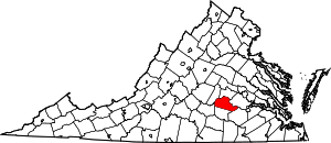 Location within the U.S. state of Virginia | |
 Virginia's location within the U.S. | |
| Coordinates: 37°20′N 77°59′W / 37.34°N 77.98°W | |
| Country | |
| State | |
| Founded | 1735 |
| Named for | Princess Amelia |
| Seat | Amelia Court House |
| Area | |
| • Total | 359 sq mi (930 km2) |
| • Land | 355 sq mi (920 km2) |
| • Water | 3.3 sq mi (9 km2) 0.9% |
| Population (2010) | |
| • Total | 12,690 |
| • Estimate (2019) | 13,145 |
| • Density | 35/sq mi (14/km2) |
| Demonym(s) | Amelian, Amellianaire |
| Time zone | UTC−5 (Eastern) |
| • Summer (DST) | UTC−4 (EDT) |
| ZIP Codes | 23002, 23083, 23105 |
| Congressional district | 7th |
| Website | www |

Amelia County is a county located just southwest of Richmond in the Commonwealth of Virginia, United States. The county is located in Central Virginia and is included in the Greater Richmond Region. Its county seat is Amelia Court House.[1]
Amelia County was created in 1735 from parts of Prince George and Brunswick counties, and was named in honor of Princess Amelia of Great Britain. Parts of the county were later carved out to create Prince Edward and Nottoway counties.
As of the 2010 census, the county population was 12,690, an increase of more than 44 percent from the 1990 census.[2]
History[]

Amelia County was created by legislative act in 1734 and 1735[3] from parts of Prince George and Brunswick counties. The county is named for Princess Amelia of Great Britain, daughter of King George II. As was customary, Amelia County was reduced by the division of territory to form newer counties as the population increased in the region; in 1754, Prince Edward County was formed from parts of Amelia County, and in 1789, Nottoway County was formed. The area was developed for plantation agriculture dependent on slave labor.
During the Civil War, Confederate general Robert E. Lee and his army spent April 4 and 5, 1865, at Amelia Court House before his surrender on April 9 to General Ulysses S. Grant at Appomattox. The last major battle of his army was fought at Sayler's Creek, on the border of Amelia and Prince Edward counties, on April 6.
Amelia is known for its minerals, including the nation's best supply of amazonite, a green feldspar found at the Morefield mine. In the 19th century, spas were developed around its mineral springs, which were destinations for travelers.
In 1986 the Amelia County Fair sponsored a competition for the world's largest potato pancake (with apple sauce). It was constructed to raise money that year for the German American National Scholarship Fund. The pancake weighed more than two and one-quarter tons and used four truckloads of potatoes.
Geography[]
According to the U.S. Census Bureau, the county has a total area of 359 square miles (930 km2), of which 355 square miles (920 km2) is land and 3.3 square miles (8.5 km2) (0.9%) is water.[4]
Amelia County lies in the Piedmont region of Virginia, known for rolling hills and small ridges that lie between the Blue Ridge Mountains and Coastal Plain of Virginia. The county is bordered on its northern and most of its western side by the Appomattox River, and by Namozine Creek on its eastern boundary.
Adjacent counties[]
- Powhatan County - north
- Chesterfield County - east
- Dinwiddie County - southeast
- Nottoway County - south
- Prince Edward County - southwest
- Cumberland County - west
Transportation[]
Air[]
- Richmond International Airport is located 51 miles (82 km) northeast of Amelia County.
US Highways[]
 US 360 (Patrick Henry Highway. Eastbound to Richmond. Westbound to Burkeville and Danville)
State Routes[]
 SR 38 (In Amelia Court House: Virginia Street, Court Street, Washington Street, Church Street, Five Forks Road. In Amelia County: N. Five Forks Road, to SR 153)
 SR 153 (Military Road. To
  US 460 and Blackstone)
 SR 307 (Holly Farms Road. To US 460 and Farmville)
Secondary Roads[]
 SR 604 Chula Rd and Genito Rd. To eastern Powhatan and Chesterfield Counties.
 SR 609 (Grub Hill Church Rd and Royalton Rd. To
  US 60 and Powhatan Court House)
 SR 614 (Dennisville Rd. To Blackstone)
 SR 616 (Genito Rd. Serves the northern and western ends of Amelia County. To SR 307 near Rice, Virginia)
Rail[]
- Norfolk Southern - freight rail service
Demographics[]
| Historical population | |||
|---|---|---|---|
| Census | Pop. | %± | |
| 1790 | 18,097 | — | |
| 1800 | 9,432 | −47.9% | |
| 1810 | 10,594 | 12.3% | |
| 1820 | 11,104 | 4.8% | |
| 1830 | 11,036 | −0.6% | |
| 1840 | 10,320 | −6.5% | |
| 1850 | 9,770 | −5.3% | |
| 1860 | 10,741 | 9.9% | |
| 1870 | 9,878 | −8.0% | |
| 1880 | 10,377 | 5.1% | |
| 1890 | 9,068 | −12.6% | |
| 1900 | 9,037 | −0.3% | |
| 1910 | 8,720 | −3.5% | |
| 1920 | 9,800 | 12.4% | |
| 1930 | 8,799 | −10.2% | |
| 1940 | 8,495 | −3.5% | |
| 1950 | 7,908 | −6.9% | |
| 1960 | 7,815 | −1.2% | |
| 1970 | 7,592 | −2.9% | |
| 1980 | 8,405 | 10.7% | |
| 1990 | 8,787 | 4.5% | |
| 2000 | 11,400 | 29.7% | |
| 2010 | 12,690 | 11.3% | |
| 2019 (est.) | 13,145 | [5] | 3.6% |
| U.S. Decennial Census[6] 1790-1960[7] 1900-1990[8] 1990-2000[9] 2010-2013[2] | |||
As of the census[10] of 2000, there were 11,400 people, 4,240 households, and 3,175 families residing in the county. The population density was 32 people per square mile (12/km2). There were 4,609 housing units, at an average density of 13 per square mile (5/km2). The racial makeup of the county was 70.57% White, 28.05% Black or African American, 0.28% Native American, 0.17% Asian, 0.02% Pacific Islander, 0.25% from other races, and 0.67% from two or more races. 0.80% of the population were Hispanic or Latino of any race.
There were 4,240 households, of which 32.80% had children under the age of 18 living with them, 59.10% were married couples living together, 11.40% had a female householder with no husband present, and 25.10% were non-families. 20.70% of all households were made up of individuals, and 8.10% had someone living alone who was 65 years of age or older. The average household size was 2.66 and the average family size was 3.07.
The ages of the population were spread out, with 25.30% under 18, 6.70% from 18 to 24, 29.20% from 25 to 44, 25.40% from 45 to 64, and 13.30% who were 65 years of age or older. The median age was 38 years. For every 100 females, there were 97.30 males. For every 100 females age 18 and over, there were 94.20 males.
The median household income in the county was $40,252, and the median family income was $47,157. Males had a median income of $32,315, versus $23,102 for females. The per capita income for the county was $18,858. 8.40% of the population and 6.70% of families were below the poverty line. Out of the total people living in poverty, 7.10% were under the age of 18 and 11.70% were 65 or older.
Culture[]
Seasonal Events[]
- A countywide festival called Amelia Day is held each May on the Saturday before Mother's Day in Amelia Court House. The festival started in the 1980s to celebrate the town's founding. Vendors, local clubs, and citizens organize to enjoy music, dancing, and socializing. At the first Amelia Day in 1985, residents signed a long roll that, along with other items, was put in a time capsule and buried in the courthouse green near the Confederate War Memorial. The capsule is scheduled to be opened in 2035.
- The Amelia County Fair is held in late summer or early fall each year at the Joe Paulette Memorial Park in Amelia Court House.
- Each October, the Amelia Frightfest, a trail haunt, opens at Tom Scott Park in Amelia Court House.
- Every year from April to October, on the second Saturday of every month, The Time Bandits car club hosts a car show in the BB&T/Truist Bank parking lot on Patrick Henry Highway.[11]
Attractions[]
- Sayler's Creek Battlefield State Park
- Lake Chesdin
- Amelia Wildlife Management Area
- Amelia Country Club
Government[]
Board of Supervisors[]
- District 1: David M. Felts Jr.
- District 2: Roger A. Scott (I)
- District 3: Shaun Weyant, Vice Chairman (I)
- District 4: H. Joseph Easter IV, Chairman (I)
- District 5: Franklin D. Harris, (D)
Constitutional officers[]
- Clerk of the Circuit Court: Marilyn L. Wilson (D)
- Commissioner of the Revenue: Laura Walsh (I)
- Commonwealth's Attorney: Lee R. Harrison (I)
- Sheriff: Rick Walker (I)
- Treasurer: Stephanie Coleman (I)
Amelia County is represented by Republican Amanda Chase in the Virginia Senate, Republican Thomas C. Wright Jr. in the Virginia House of Delegates, and Democrat Abigail Spanberger in the U.S. House of Representatives.
Media[]
The Amelia Bulletin Monitor, a weekly newspaper, has covered the county since 1973.
Education[]
Public Primary and secondary schools[]
Amelia County is served by the Amelia County School District
- Amelia County High School
- Amelia County Middle School
- Amelia County Elementary School
Private Primary and secondary Schools[]
Communities[]
There are no incorporated communities in Amelia County.
Census-designated places[]
Unincorporated Communities[]
NRHP Sites[]
The following sites in Amelia County are listed on the National Register of Historic Places:
- Barrett-Chumney House
- Dykeland
- Egglestetton
- Farmer House
- Haw Branch
- Ingleside
- St. Johns Church
- Sayler's Creek Battlefield
- Wigwam
- Winterham Plantation
Notable residents[]
- William S. Archer, born in Amelia County, United States Senator from Virginia[13]
- Van T. Barfoot (1919-2012), U.S. Army Colonel and a U.S. Congressional Medal of Honor Recipient
- William Wyatt Bibb, born in Amelia County, United States Senator from Georgia and first Governor of Alabama[13]
- Jesse Bragg, Negro league baseball player
- William Cocke (1747–1828), born in Amelia County, first United States Senator from Tennessee[13]
- Henry William Connor (1793–1866), born near Amelia Court House, elected United States Congressman from North Carolina[13]
- David Fanning, (1755–1825), born in Amelia County. A Loyalist officer during the American Revolutionary War, he captured Thomas Burke, a court-martial judge and Governor of North Carolina. One of only three individuals excluded from the amnesty after the Revolutionary War, Fanning moved to New Brunswick in present-day Canada for resettlement.[13]
- William Branch Giles, (1762–1830), born in Amelia County. Planter, United States Congressman, United States Senator, and Governor of Virginia[13]
- Edmund Harrison (1764–1826), Speaker of the Virginia House of Delegates (1802–1803)
- John Winston Jones, (1791–1848), born in Amelia County. Speaker of the United States House of Representatives[13]
- Nellie A. Ramsey Leslie (c.1840s-c.1920s), born into slavery in Amelia County.[14] She became a noted musician, teacher and composer, founding a musical conservatory in Corpus Christi, Texas.
- Robert Russa Moton (1867–1940), noted African American educator. He was born in Amelia County but was raised in Rice, in nearby Prince Edward County, Virginia.
- Mary Virginia Terhune (1830-1922), born in Amelia County. A prolific and bestselling author in both fiction and non-fiction, the first woman elected to the Virginia Historical Society
References[]
- ^ "Find a County". National Association of Counties. Archived from the original on 2011-05-31. Retrieved 2011-06-07.
- ^ Jump up to: a b "State & County QuickFacts". United States Census Bureau. Archived from the original on July 6, 2011. Retrieved December 31, 2013.
- ^ History of Amelia County Archived 2010-12-05 at the Wayback Machine
- ^ "US Gazetteer files: 2010, 2000, and 1990". United States Census Bureau. 2011-02-12. Retrieved 2011-04-23.
- ^ "Population and Housing Unit Estimates". Retrieved March 9, 2021.
- ^ "U.S. Decennial Census". United States Census Bureau. Retrieved December 31, 2013.
- ^ "Historical Census Browser". University of Virginia Library. Retrieved December 31, 2013.
- ^ "Population of Counties by Decennial Census: 1900 to 1990". United States Census Bureau. Retrieved December 31, 2013.
- ^ "Census 2000 PHC-T-4. Ranking Tables for Counties: 1990 and 2000" (PDF). United States Census Bureau. Retrieved December 31, 2013.
- ^ "U.S. Census website". United States Census Bureau. Retrieved 2011-05-14.
- ^ https://pistonrepublic.com/events/cruise-in-hosted-by-the-time-bandits-car-club-amelia-court-house-va-04-10-2021
- ^ David Leip. "Dave Leip's Atlas of U.S. Presidential Elections". Uselectionatlas.org. Retrieved 2020-12-09.
- ^ Jump up to: a b c d e f g Who Was Who in America, Historical Volume, 1607-1896. Chicago: Marquis Who's Who. 1963.
- ^ Scruggs, Lawson Andrew (1893). Women of Distinction: Remarkable in Works and Invincible in Character. Raleigh, North Carolina: L. A. Scruggs. p. 247. OCLC 4255360.
External links[]
- http://www.ameliacova.com - Official Amelia County Website
- https://web.archive.org/web/20191115180811/http://ameliabusinessdirectory.com/ - Amelia Business Directory
- Amelia Co. Christmas 1784
- http://www.ameliamonitor.com - Amelia County's newspaper
- http://www.ameliadayfestival.com/ - Amelia Day Website
- https://ameliacountyfair.com/ - Amelia Fair website
| show Places adjacent to Amelia County, Virginia |
|---|
| show Municipalities and communities of Amelia County, Virginia, United States |
|---|


Coordinates: 37°20′N 77°59′W / 37.34°N 77.98°W
| show Authority control |
|---|
- Virginia counties
- Amelia County, Virginia
- Populated places established in 1735
- 1735 establishments in the Thirteen Colonies