Ancient and Primeval Beech Forests of the Carpathians and Other Regions of Europe
| UNESCO World Heritage Site | |
|---|---|
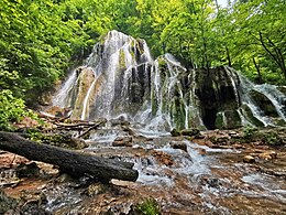 Beușnița Waterfall in Nera Gorge-Beușnița National Park | |
| Location | (see map) |
| Reference | 1133quater |
| Inscription | 2007 (31st Session) |
| Extensions | 2011, 2017, 2021 |
Ancient and Primeval Beech Forests of the Carpathians and Other Regions of Europe is a transnational serial nature UNESCO World Heritage Site, encompassing 94 component parts (forests) in 18 European countries.[1]
Carpathian region[]
This section needs to be updated. The reason given is: This part appears to be written before 2017. (August 2021) |
The Primeval Beech Forests of the Carpathians include ten separate massifs located along the 185 km (115 mi) long axis from the Rakhiv mountains and Chornohora ridge in Ukraine over the Poloniny Ridge (Slovakia) to the Vihorlat Mountains in Slovakia. The Ancient Beech Forests of Germany include five locations, cover 4,391 hectares and were added in 2011.
The Carpathian site covers a total area of 77,971.6 ha (192,672 acres), out of which only 29,278.9 ha (72,350 acres) are part of the actual preserved area, while the rest is considered a "buffer zone". Primeval Beech Forests of the Carpathians cover areas of Zakarpattia and Prešov Regions. Over 70% of the site is located in Ukraine. The area includes two national parks, and some habitat controlled areas, mostly in Slovakia. Both national parks, along with a neighboring area in Poland, compose a separate biosphere reserve, the East Carpathian Biosphere Reserve. Besides Havešová, Rožok, and Stužica (all of them located in Bukovské vrchy), there is a fourth component situated in Slovakia, named Kyjovský prales of Vihorlat. Ukrainian locations include Chornohora, Kuziy-Trybushany, Maramarosh, Stuzhytsia–Uzhok, Svydovets, and Uholka–Shyrikyi Luh. Only a few of the ten components are accessible to visitors. Stužica is the only one of three locations in Bukovské vrchy (Slovakia) with available hiking trails. In 2017, UNESCO extended the site, adding forests in Albania, Austria, Belgium, Bulgaria, Croatia, Italy, Romania, Slovenia, and Spain.[2][3]
The last intact virgin forest in the temperate latitudes of Europe is to be found in the Carpathians. Trees can live to a hundred years old in these forests, providing an important habitat for organisms such as mushrooms, moss, lichen, insects, rare birds (e.g. capercaillie and black grouse) and mammals (e.g. bats, brown bear, wolf and lynx). Large parts of the forest in the Romanian part of the Carpathians have been lost due to deforestation. The pressure on timber as a resource may increase due to international demand and European companies may start large-scale felling in neighbouring Ukraine. Currently unprotected areas of virgin forest can be permanently preserved in the Ukrainian Carpathians by expanding and reinforcing conservation areas. In the Ukrainian Carpathians there are nine national parks and two biosphere reserves. There is a general ban on tree felling in coniferous forest areas above 1,100 metres. If park administrations are shown to work, management of larger, previously unprotected areas of virgin forest to preserve them on a permanent basis, may occur. There are roughly 100,000 additional hectares of forest which could be integrated into the existing conservation areas.[4]
List of component parts[]

The component parts included in the site as of August 2021 are:[1][5][6][7][8][9][10][11][12]
| Country | Serial ID No. or ID |
Component part | Component cluster | Property [ha] | Buffer zone [ha] |
Year inscrib. |
Centre point coordinates |
|---|---|---|---|---|---|---|---|
| Carpathian Beech Forest Region | |||||||
| Ukraine | 1133-001 | Chornohora | 2,476.80 | 12,925.00 | 2007 | 48°8′25″N 24°23′35″E / 48.14028°N 24.39306°E | |
| 1133-003 | 1,369.60 | 3,163.40 | 2007 | 47°56′21″N 24°8′26″E / 47.93917°N 24.14056°E | |||
| 1133-004 | 2,243.60 | 6,230.40 | 2007 | 47°56′12″N 24°19′35″E / 47.93667°N 24.32639°E | |||
| 1133-007 | Stuzhytsia-Uzhok | 2,532.00 | 3,615.00 | 2007 | 49°4′58″N 22°35′45″E / 49.08278°N 22.59583°E[n 1] | ||
| 1133-008 | Svydovets | 3,030.50 | 5,639.50 | 2007 | 48°11′21″N 24°13′37″E / 48.18917°N 24.22694°E | ||
| 1133-009 | Uholka-Shyrokyi Luh[n 2] | 11,860.00 | 3,301.00 | 2007 | 48°18′22″N 23°41′46″E / 48.30611°N 23.69611°E | ||
| 1133ter-055 | Gorgany | 753.48 | 4,637.59 | 2017 | 48°28′19″N 24°17′58″E / 48.47194°N 24.29944°E | ||
| 1133ter-058 | Synevyr | 1,588.46 | 312.32 | 2017 | 48°29′14″N 23°44′56″E / 48.48722°N 23.74889°E | ||
| 1133ter-059 | 561.62 | 333.63 | 2017 | 48°23′6″N 23°42′46″E / 48.38500°N 23.71278°E | |||
| 1133ter-060 | Strymba | 260.65 | 191.14 | 2017 | 48°27′11″N 23°47′48″E / 48.45306°N 23.79667°E | ||
| 1133ter-061 | 454.31 | 253.85 | 2017 | 48°21′20″N 23°39′36″E / 48.35556°N 23.66000°E | |||
| 1133ter-062 | Zacharovanyi Krai | 93.97 | 1,275.44 | 2017 | 48°27′9″N 23°5′23″E / 48.45250°N 23.08972°E | ||
| 1133ter-063 | 1,164.16 | 2017 | 48°25′21″N 23°9′42″E / 48.42250°N 23.16167°E | ||||
| Slovakia | 1133-002 1133quater-103 SK-POLO-01* |
Poloniny | 167.88 | 6,474.84 | 2007 2021* |
49°0′35″N 22°20′14″E / 49.00972°N 22.33722°E | |
| 1133-005 1133quater-104 SK-POLO-02* |
74.37 | 1,138.89 | 2007 2021* |
48°58′40″N 22°27′52″E / 48.97778°N 22.46444°E | |||
| 1133-006 1133quater-105 SK-POLO-03* |
Stužica – Bukovské Vrchy | 1,742.47 | 5,694.84 | 2007 2021* |
49°5′3″N 22°29′42″E / 49.08417°N 22.49500°E | ||
| 1133-006 1133quater-106 SK-POLO-04* |
455.82 | 814.69 | 2007 2021* |
49°10′31″N 22°13′39″E / 49.17528°N 22.22750°E | |||
| 1133-010 1133quater-108 SK-VIHO-02* |
Vihorlat | 1,553.06 | 854.08 | 2007 2021* |
48°54′56″N 22°11′13″E / 48.91556°N 22.18694°E | ||
| Romania | 1133ter-035 | Cheile Nerei-Beușnița | 4,292.27 | 5,959.87 | 2017 | 44°54′19″N 21°48′40″E / 44.90528°N 21.81111°E | |
| 1133ter-036 | (Codrul secular Șinca) | 338.24 | 445.76 | 2017 | 45°40′0″N 25°10′14″E / 45.66667°N 25.17056°E | ||
| 1133ter-037 | (Codrul secular Slătioara) | 609.12 | 429.43 | 2017 | 47°26′36″N 25°37′39″E / 47.44333°N 25.62750°E | ||
| 1133ter-038 | Cozia | 2,285.86 | 2,408.83 | 2017 | 45°19′54″N 24°19′32″E / 45.33167°N 24.32556°E | ||
| 1133ter-039 | 1,103.30 | 2017 | 45°17′43″N 24°15′33″E / 45.29528°N 24.25917°E | ||||
| 1133ter-040 | Domogled-Coronini-Bedina | Domogled – Valea Cernei |
5,110.63 | 51,461.28 | 2017 | 44°56′31″N 22°28′7″E / 44.94194°N 22.46861°E | |
| 1133ter-041 | 3,517.36 | 2017 | 45°6′31″N 22°34′41″E / 45.10861°N 22.57806°E | ||||
| 1133ter-042 | 1,104.27 | 2017 | 45°14′40″N 22°49′23″E / 45.24444°N 22.82306°E | ||||
| 1133ter-043 | Groșii Țibleșului | 210.55 | 563.57 | 2017 | 47°32′59″N 24°11′9″E / 47.54972°N 24.18583°E | ||
| 1133ter-044 | 135.82 | 2017 | 47°32′5″N 24°13′13″E / 47.53472°N 24.22028°E | ||||
| 1133ter-045 | Izvoarele Nerei | 4,677.21 | 2,494.83 | 2017 | 45°7′21″N 22°3′59″E / 45.12250°N 22.06639°E | ||
| 1133ter-046 | Strâmbu Băiuț[n 3] | 598.14 | 713.09 | 2017 | 47°37′33″N 24°4′23″E / 47.62583°N 24.07306°E | ||
| Poland | 1133quater-094 PL-BIES-01 |
and valley[n 4] |
Bieszczady | 1,506.05 | 24,330.52 | 2021 | 49°5′58″N 22°33′24″E / 49.09944°N 22.55667°E |
| 1133quater-095 PL-BIES-02 |
and [n 5] | 1,178.03 | 2021 | 49°10′51″N 22°30′12″E / 49.18083°N 22.50333°E | |||
| 1133quater-096 PL-BIES-03 |
stream valley | 201.00 | 2021 | 49°5′37″N 22°43′29″E / 49.09361°N 22.72472°E | |||
| 1133quater-097 PL-BIES-04 |
Wołosatka stream valley | 586.66 | 2021 | 49°4′1″N 22°44′41″E / 49.06694°N 22.74472°E | |||
| Polonic-Podoloc-Moldovan Beech Forest Region | |||||||
| Ukraine | 1133ter-056 | [n 6] | 384.81 | 598.21 | 2017 | 49°57′44″N 23°38′58″E / 49.96222°N 23.64944°E | |
| 1133ter-057 | Satanіvska Dacha | 212.01 | 559.37 | 2017 | 49°10′26″N 26°14′56″E / 49.17389°N 26.24889°E | ||
| Baltic Beech Forest Region | |||||||
| Germany | 1133bis-011 | Jasmund | 492.50 | 2,510.50 | 2011 | 54°32′53″N 13°38′43″E / 54.54806°N 13.64528°E | |
| 1133bis-012 | Serrahn | 268.10 | 2,568.00 | 2011 | 53°20′24″N 13°11′52″E / 53.34000°N 13.19778°E | ||
| 1133bis-013 | 590.10 | 274.30 | 2011 | 52°59′11″N 13°53′44″E / 52.98639°N 13.89556°E | |||
| Subatlantic-Hercynic Beech Forest Region | |||||||
| Germany | 1133bis-014 | Hainich | 1,573.40 | 4,085.40 | 2011 | 51°04′43″N 10°26′08″E / 51.07861°N 10.43556°E | |
| 1133bis-015 | Kellerwald | 1,467.10 | 4,271.40 | 2011 | 51°08′43″N 8°58′25″E / 51.14528°N 8.97361°E | ||
| Czech Republic | 1133quater-076 CZ-JIZE-01 |
Jizera Mountains | 444.81 | 2,279.40 | 2021 | 50°51′30″N 15°9′20″E / 50.85833°N 15.15556°E | |
| France | 1133quater-082 FR-GRAN-01 |
319.00 | 1,328.00 | 2021 | 47°58′20″N 6°56′23″E / 47.97222°N 6.93972°E | ||
| Switzerland | 1133quater-074 CH-BETT-01 |
(Forêt de la Bettlachstock) |
195.43 | 1,094.16 | 2021 | 47°13′22″N 7°24′43″E / 47.22278°N 7.41194°E | |
| Alpic Beech Forest Region | |||||||
| Austria | 1133ter-003 | 1,867.45 | 1,545.05 | 2017 | 47°46′12″N 15°2′51″E / 47.77000°N 15.04750°E | ||
| 1133ter-004 | Kalkalpen | 2,946.20 | 14,197.24 | 2017 | 47°44′58″N 14°28′56″E / 47.74944°N 14.48222°E | ||
| 1133ter-005 | 890.89 | 2017 | 47°47′14″N 14°21′12″E / 47.78722°N 14.35333°E | ||||
| 1133ter-006 | 264.82 | 2017 | 47°48′15″N 14°14′22″E / 47.80417°N 14.23944°E | ||||
| 1133ter-007 | 1,149.75 | 2017 | 47°50′00″N 14°26′1″E / 47.83333°N 14.43361°E | ||||
| Switzerland | 1133quater-075 CH-LODA-01 |
Forest reserves of Lodano, Busai and Soladino Valleys | 806.78 | 2,330.74 | 2021 | 46°15′49″N 8°39′11″E / 46.26361°N 8.65306°E | |
| France | 1133quater-078 FR-CHAP-01 |
371.30 | 41.65 | 2021 | 44°38′4″N 5°59′55″E / 44.63444°N 5.99861°E | ||
| Atlantic Beech Forest Region | |||||||
| Belgium | 1133ter-008 | Sonian Forest (Forêt de Soignes) |
187.34 | 4,650.86 | 2017 | 50°45′23″N 4°25′00″E / 50.75639°N 4.41667°E | |
| 1133ter-009 | 24.11 | 2017 | 50°46′54″N 4°25′36″E / 50.78167°N 4.42667°E | ||||
| 1133ter-010 | Grippensdelle B | 37.38 | 2017 | 50°47′1″N 4°25′57″E / 50.78361°N 4.43250°E | |||
| 1133ter-011 | 13.98 | 2017 | 50°44′3″N 4°26′13″E / 50.73417°N 4.43694°E | ||||
| 1133ter-012 | Réserve forestière du Ticton B | 6.50 | 2017 | 50°43′37″N 4°25′51″E / 50.72694°N 4.43083°E | |||
| Moesian-Balcanic Beech Forest Region | |||||||
| Albania | 1133ter-001 | Lumi i gashit | 1,261.52 | 8,977.48 | 2017 | 42°28′53″N 20°3′26″E / 42.48139°N 20.05722°E | |
| 1133ter-002 | Rrajca | 2,129.45 | 2,569.75 | 2017 | 41°12′11″N 20°30′2″E / 41.20306°N 20.50056°E | ||
| North Macedonia | 1133quater-093 MN-DLAB-01 |
Dlaboka Reka | 193.27 | 234.70 | 2021 | 41°45′47″N 20°35′16″E / 41.76306°N 20.58778°E | |
| Bulgaria | 1133ter-013 | Reserve | Central Balkan | 1,226.88 | 851.22 | 2017 | 42°48′10″N 24°16′9″E / 42.80278°N 24.26917°E |
| 1133ter-014 | 1,485.81 | 1,945.99 | 2017 | 42°46′32″N 24°24′18″E / 42.77556°N 24.40500°E | |||
| 1133ter-015 | Reserve | 644,43 | 289.82 | 2017 | 42°47′47″N 24°31′2″E / 42.79639°N 24.51722°E | ||
| 1133ter-016 | Reserve[n 7] | 2,466.10 | 1,762.01 | 2017 | 42°44′43″N 24°42′26″E / 42.74528°N 24.70722°E | ||
| 1133ter-017 | Stara Reka Reserve[n 8] | 591.20 | 1,480.04 | 2017 | 42°42′11″N 24°49′8″E / 42.70306°N 24.81889°E | ||
| 1133ter-018 | Dzhendema Reserve | 1,774.12 | 2,576.63 | 2017 | 42°41′44″N 24°58′23″E / 42.69556°N 24.97306°E | ||
| 1133ter-019 | Reserve | 926.37 | 1,066.47 | 2017 | 42°44′44″N 24°56′5″E / 42.74556°N 24.93472°E | ||
| 1133ter-020 | Reserve[n 9] | 1,049.10 | 968.14 | 2017 | 42°45′54″N 25°4′29″E / 42.76500°N 25.07472°E | ||
| 1133ter-021 | 824.90 | 780.55 | 2017 | 42°41′52″N 25°8′18″E / 42.69778°N 25.13833°E | |||
| Illyric Beech Forest Region | |||||||
| Croatia | 1133ter-022 | Forest reserves Hajdučki i Rožanski kukovi | 1,289.11 | 9,869.25 | 2017 | 44°45′59″N 15°0′39″E / 44.76639°N 15.01083°E | |
| 1133ter-023 | Paklenica National Park | 1,241.04 | 414.76 | 2017 | 44°20′26″N 15°30′1″E / 44.34056°N 15.50028°E | ||
| 1133ter-024 | 790,74 | 395.35 | 2017 | 44°23′4″N 15°26′59″E / 44.38444°N 15.44972°E | |||
| Slovenia | 1133ter-047 | 74.50 | 47.90 | 2017 | 45°32′31″N 14°46′8″E / 45.54194°N 14.76889°E | ||
| 1133ter-048 | 720.24 | 128.80 | 2017 | 45°35′5″N 14°27′19″E / 45.58472°N 14.45528°E | |||
| Bosnia and Herzegovina |
1133quater-073 BH-JANJ-01 |
295.04 | 380.74 | 2021 | 44°8′48″N 17°16′52″E / 44.14667°N 17.28111°E | ||
| Central Mediterranean Beech Forest Region | |||||||
| Italy | 1133ter-025 | (Valle Cervara) | Abruzzo, Lazio & Molise | 119.70 | 751.61 | 2017 | 41°49′56″N 13°43′43″E / 41.83222°N 13.72861°E |
| 1133ter-026 | 192.70 | 2017 | 41°50′49″N 13°42′20″E / 41.84694°N 13.70556°E | ||||
| 1133ter-027 | 104.71 | 415.51 | 2017 | 41°51′37″N 13°50′48″E / 41.86028°N 13.84667°E | |||
| 1133ter-028 | 194.49 | 446.62 | 2017 | 41°47′15″N 13°44′39″E / 41.78750°N 13.74417°E | |||
| 1133ter-029 | (Val Fondillo) | 325.03 | 700.95 | 2017 | 41°45′15″N 13°53′9″E / 41.75417°N 13.88583°E | ||
| 1133ter-030 1133quater-088 IT-POLL-01* |
Pollino National Park | 95.75 | 2,851.83 | 2017 2021* |
39°54′19″N 16°6′4″E / 39.90528°N 16.10111°E | ||
| 1133quater-089 IT-POLL-02 |
477.94 | 2021 | 39°53′43″N 16°11′54″E / 39.89528°N 16.19833°E | ||||
| 1133quater-090 IT-VALL-01 |
Infernale Valley (Valle Infernale) | 320.79 | 2,191.36 | 2021 | 38°7′55″N 15°57′41″E / 38.13194°N 15.96139°E | ||
| 1133ter-031 1133quater-086 IT-FUMB-01* |
Umbra Forest (Foresta Umbra) |
254.30 | 3,486.29 | 2017 2021* |
41°48′21″N 15°58′41″E / 41.80583°N 15.97806°E | ||
| 1133quater-087 IT-FUMB-02 |
667.13 | 2021 | 41°50′20″N 16°1′25″E / 41.83889°N 16.02361°E | ||||
| 1133ter-032 | 57.54 | 87.96 | 2017 | 42°24′31″N 12°12′11″E / 42.40861°N 12.20306°E | |||
| 1133ter-033 | 73.73 | 54.75 | 2017 | 42°10′25″N 12°9′40″E / 42.17361°N 12.16111°E | |||
| 1133ter-034 | 781.43 | 6,936.64 | 2017 | 43°50′40″N 11°48′11″E / 43.84444°N 11.80306°E | |||
| Pyrenaic-Iberian Beech Forest Region | |||||||
| Spain | 1133ter-049 | (Hayedos de Ayllón) |
255.52 | 13,880.86 | 2017 | 41°14′43″N 3°23′19″W / 41.24528°N 3.38861°W[n 10] | |
| 1133ter-050 | Montejo | 71.79 | 2017 | 41°6′44″N 3°29′58″W / 41.11222°N 3.49944°W | |||
| 1133ter-051 | (Hayedos de Navarra) |
63.97 | 24,494.52 | 2017 | 43°0′23″N 1°6′46″W / 43.00639°N 1.11278°W | ||
| 1133ter-052 | 171.06 | 2017 | 42°54′39″N 0°48′58″W / 42.91083°N 0.81611°W | ||||
| 1133ter-053 | Beech forests of Picos de Europa (Hayedos de Picos de Europa) |
213.65 | 14,253.00 | 2017 | 43°10′21″N 4°59′16″W / 43.17250°N 4.98778°W | ||
| 1133ter-054 | 109.58 | 2017 | 43°10′16″N 4°53′21″W / 43.17111°N 4.88917°W | ||||
| France | 1133quater-083 FR-MASS-01 |
239.50 | 1,432.30 | 2021 | 42°28′58″N 3°1′45″E / 42.48278°N 3.02917°E | ||

* Only boundary modification.
Udava (Bukovské Vrchy, Slovakia) was created by modifying the boundary of Stužica before. Falascone (Italy) in turn was named previously Umbra Forest (Foresta Umbra).[11][12]
This is a transnational serial nature UNESCO World Heritage Site, encompassing 94 component parts (forests) in 18 European countries.[1] The total area of component parts is 98,125.15 ha (242,472.5 acres), including buffer zones 392,846.02 ha (970,743.7 acres). The largest total area of component parts is in Ukraine and Romania – 54% total (41% including buffer zones).
Forms of protection[]
Component parts of this property overlap more or less with various protected areas like national parks, nature reserves, Natura 2000 network.[13][14][15][9][11][16][17]
Abbreviations:
C – count of component parts in a given cluster
N – overlapping with Natura 2000 areas
| Country | Component cluster | C | Protected area | N | Region |
|---|---|---|---|---|---|
| Albania | Lumi i Gashit | 1 | Strict nature reserve of Gashi River | Kukës | |
| 1 | Shebenik – Jabllanicë National Park | Elbasan | |||
| Austria | Dürrenstein | 1 | Wilderness Area Dürrenstein | Yes | Lower Austria |
| 4 | Kalkalpen National Park | Yes | Upper Austria | ||
| Belgium | Sonian Forest (Forêt de Soignes) |
5 | 3 strict forest reserves within Sonian Forest Protected Landscape – , and | Yes | Flanders, Brussels Capital Region, Wallonia |
| Bosnia and Herzegovina | 1 | Prašuma Janj strict nature reserve | Bosanska Krajina | ||
| Bulgaria | Central Balkan | 9 | 9 strict reserves in the Central Balkan National Park – , Dzhendema, , [n 9], , , Stara reka, and Tsarichina | Yes | Lovech, Plovdiv, Stara Zagora, Gabrovo (central Balkan Mountains) |
| Croatia | Hajdučki i Rožanski kukovi | 1 | Hajdučki and Rožanski Kukovi strict reserve within Northern Velebit National Park | Yes | Lika-Senj |
| Paklenica National Park | 2 | Yes | Lika-Senj, Zadar (Dinaric region, or Dinaric Alps) | ||
| Czech Republic | Jizera Mountains | 1 | Jizerské hory National Nature Reserve | Yes | Liberec |
| France | 1 | Chapitre-Petit-Buëch biological strict reserve | Yes | Provence-Alpes-Côte d'Azur | |
| 1 | Massif du Grand Ventron National Nature Reserve | Yes | Grand Est | ||
| 1 | Massane National Nature Reserve | Yes | Occitanie | ||
| Germany | 1 | Schorfheide-Chorin Biosphere Reserve | Yes | Brandenburg | |
| Hainich | 1 | Hainich National Park | Yes | Thuringia | |
| Jasmund | 1 | Jasmund National Park | Yes | Mecklenburg-Vorpommern | |
| Kellerwald | 1 | Kellerwald-Edersee National Park | Yes | Hesse | |
| Serrahn | 1 | Müritz National Park | Yes | Mecklenburg-Vorpommern | |
| Italy | 5 | Abruzzo, Lazio and Molise National Park | Yes | Abruzzo | |
| (Foresta Umbra) | 2 | Strict reserves within Gargano National Park – , and Foresta Umbra | Yes | Apulia | |
| 1 | Regional Natural Monument and municipal strict reserve | Yes | Lazio | ||
| 1 | Yes | Lazio | |||
| Pollino National Park | 2 | and strict reserves within Pollino National Park | Yes | Calabria, Basilicata | |
| 1 | Sasso Fratino strict reserve in Foreste Casentinesi, Monte Falterona, Campigna National Park | Yes | Emilia-Romagna, Tuscany | ||
| (Valle Infernale) | 1 | Valle Infernale strict reserve within Aspromonte National Park | Yes | South Calabria | |
| North Macedonia | Dlaboka Reka | 1 | Forest reserves within Mavrovo National Park | Mavrovo and Rostuša and Gostivar | |
| Poland | Bieszczady | 4 | Bieszczady National Park, East Carpathian Biosphere Reserve | Yes | Podkarpackie Voivodeship |
| Romania | 1 | Strictly protected zone of the Cheile Nerei-Beușnița National Park | Yes | Caraș-Severin | |
(Codrul secular Șinca) |
1 | Strictly protected through the forest management plan | Yes | Brașov | |
(Codrul secular Slătioara) |
1 | Part of Codrul Secular Slătioara forest reserve, floristic reserve | Yes | Suceava | |
| 2 | Cozia National Park | Yes | Vâlcea | ||
| 3 | Domogled-Valea Cernei National Park | Yes | Mehedinți, Caraș-Severin, Gorj | ||
| Groșii Țibleșului | 2 | Strictly protected through the forest management plan | Yes | Maramureș | |
| 1 | Izvoarele Nerei strict reserve within Semenic-Cheile Carașului National Park | Yes | Caraș-Severin | ||
| Strâmbu Băiuț[n 3] | 1 | Strictly protected through the forest management plan | Yes | Maramureș | |
| Slovakia | Poloniny | 4 | National nature reserves Stužica, , and (Stužica – Bukovské Vrchy), Rožok, , nature reserve within Poloniny National Park, East Carpathian Biosphere Reserve | Yes | Prešov |
| Vihorlat | 1 | Vihorlat national nature reserve within Vihorlat Protected Landscape Area | Yes | Prešov | |
| Slovenia | 1 | Forest reserve Virgin forest Krokar | Yes | Kočevje | |
| 1 | Snežnik–Ždrocle forest reserve | Yes | Inner Carniola | ||
| Spain | (Hayedos de Ayllón) |
2 | : , Montejo: | Yes | Castilla-La Mancha |
(Hayedos de Navarra) |
2 | Integral (strict) reserves of and | Yes | Navarre | |
(Hayedos de Picos de Europa) |
2 | Picos de Europa National Park, Biosphere Reserve | Yes | Castile and León | |
| Switzerland | (Forêt de la Bettlachstock) |
1 | Forest reserve –Hasenmatt | Canton of Solothurn | |
| Forest reserves of Lodano, Busai and Soladino Valleys | 1 | Lodano Valley forest reserve, Busai and Soladino Valleys forest reserve | Canton of Ticino | ||
| Ukraine | Chornohora | 1 | Carpathian Biosphere Reserve | Zakarpattia | |
| 1 | Carpathian Biosphere Reserve | Zakarpattia | |||
| Maramarosh | 1 | Carpathian Biosphere Reserve | Zakarpattia | ||
| 1 | Uzhanian National Nature Park | Zakarpattia | |||
| Svydovets | 1 | Carpathian Biosphere Reserve | Zakarpattia | ||
| [n 2] | 1 | Carpathian Biosphere Reserve | Zakarpattia | ||
| Synevyr | 4 | Synevyr National Nature Park | Zakarpattia | ||
| 2 | Zacharovany Krai National Nature Park | Zakarpattia | |||
| Gorgany | 1 | Gorgany Nature Reserve | Ivano-Frankivsk | ||
| [n 6] | 1 | , Roztochia Biosphere Reserve | Lviv | ||
| 1 | Podilski Tovtry National Nature Park | Khmelnytskyi |
Tentative list[]
This forest is placed on the World Heritage Tentative list as a proposal for the expansion of the Ancient and Primeval Beech Forests of the Carpathians and Other Regions of Europe site:
Montenegro[18]
- Virgin Forest Reserve in NP Biogradska Gora
Gallery[]
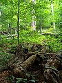
Forest in Stuzica
Havešová
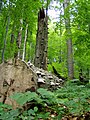
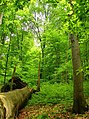
Stužica

Freshwater stream in Stužica

Stužica

Dlaboka Reka


Notes[]
- ^ Geographic coordinates corrected from "N49 4 14 E22 3 1" to N49°4’58’’ E22°35’45’’
- ^ Jump up to: a b "Uholka-Shyrikyi Luh" corrected to "Uholka-Shyrokyi Luh".
- ^ Jump up to: a b "Strimbu Băiuț" changed to "Strâmbu Băiuț".
- ^ "Gorna Solinka" corrected to "Górna Solinka".
- ^ "Polonina Wetlinska" corrected to "Połonina Wetlińska".
- ^ Jump up to: a b "Roztochya" corrected to "Roztochchya".
- ^ "Stara reka Reserve[8][10]" corrected to "Steneto Reserve[5][8]".
- ^ "Severen Dzhendem Reserve[8][10]" corrected to "Stara Reka Reserve[5][8]".
- ^ Jump up to: a b "Peesh skali" corrected to "Peeshti skali".
- ^ Latitude corrected from "N41 143" to N41°14’43’’
References[]
- ^ Jump up to: a b c "Ancient and Primeval Beech Forests of the Carpathians and Other Regions of Europe". UNESCO. Retrieved 29 July 2021.
- ^ Centre, UNESCO World Heritage. "Ancient and Primeval Beech Forests of the Carpathians and Other Regions of Europe". UNESCO.
- ^ "Unesco approves the extension of the Carpathian Primary Beech forests".
- ^ "Protecting virgin forest in the Ukrainian Carpathians".
- ^ Jump up to: a b c Jovanović, Ivana; Dragišić, Aleksandar; Ostojić, Dragana; Krsteski, Biljana (2019). "BEECH FORESTS AS WORLD HERITAGE IN ASPECT TO THE NEXT EXTENSION OF THE ANCIENT AND PRIMEVAL BEECH FORESTS OF THE CARPATHIANS AND OTHER REGIONS OF EUROPE WORLD HERITAGE SITE". Nature Conservation. 69 (1–2): 15–32. Retrieved 2 August 2021.
- ^ UNITED NATIONS EDUCATIONAL, SCIENTIFIC AND CULTURAL ORGANIZATION; CONVENTION CONCERNING THE PROTECTION OF THE WORLD CULTURAL AND NATURAL HERITAGE; WORLD HERITAGE COMMITTEE (11 May 2007). "WHC-07/31.COM/8B; Item 8B of the Provisional Agenda: Nominations to the World Heritage List" (PDF). World Heritage. 31.COM: Thirty first Session, Christchurch, New Zealand, 23 June – 2 July 2007. Paris: UNESCO. Retrieved 7 August 2021.CS1 maint: multiple names: authors list (link)
- ^ UNITED NATIONS EDUCATIONAL, SCIENTIFIC AND CULTURAL ORGANIZATION; CONVENTION CONCERNING THE PROTECTION OF THE WORLD CULTURAL AND NATURAL HERITAGE; WORLD HERITAGE COMMITTEE (6 May 2011). "WHC-11/35.COM/8B; Item 8 of the Provisional Agenda: Establishment of the World Heritage List and of the List of World Heritage in Danger; 8B. Nominations to the World Heritage List" (PDF). World Heritage. 35.COM: Thirty-fifth session, Paris, UNESCO Headquarters, 19 – 29 June 2011. Paris: UNESCO. Retrieved 7 August 2021.CS1 maint: multiple names: authors list (link)
- ^ Jump up to: a b c d e UNITED NATIONS EDUCATIONAL, SCIENTIFIC AND CULTURAL ORGANIZATION; CONVENTION CONCERNING THE PROTECTION OF THE WORLD CULTURAL AND NATURAL HERITAGE WORLD HERITAGE COMMITTEE (19 May 2017). "WHC/17/41.COM/8B; Item 8 of the Provisional Agenda: Establishment of the World Heritage List and of the List of World Heritage in Danger; 8B. Nominations to the World Heritage List" (PDF). World Heritage. 41.COM: Forty first session, Krakow, Poland, 2 12 July 2017. Paris: UNESCO. Retrieved 7 August 2021.CS1 maint: multiple names: authors list (link)
- ^ Jump up to: a b "Primeval Beech Forests of the Carpathians and Other Regions of Europe" as extension to the existing Natural World Heritage Site "Primeval Beech Forests of the Carpathians and the Ancient Beech Forests of Germany" (1133bis). NOMINATION DOSSIER to the UNESCO for the Inscription on the World Heritage List. IUCN. January 2017. Retrieved 7 August 2021.
- ^ Jump up to: a b c UNITED NATIONS EDUCATIONAL, SCIENTIFIC AND CULTURAL ORGANIZATION; CONVENTION CONCERNING THE PROTECTION OF THE WORLD CULTURAL AND NATURAL HERITAGE; WORLD HERITAGE COMMITTEE (4 June 2021). "WHC/21/44.COM/8B; Item 8 of the Provisional Agenda: Establishment of the World Heritage List and of the List of World Heritage in Danger; 8B. Nominations to the World Heritage List". World Heritage. 31.COM: Extended forty-fourth session, Fuzhou (China) / Online meeting, 16 – 31 July 2021. Paris: UNESCO. Retrieved 7 August 2021.CS1 maint: multiple names: authors list (link)
- ^ Jump up to: a b c 'Ancient and Primeval Beech Forests of the Carpathians and Other Regions of Europe' as extension to the existing Natural World Heritage Site 'Ancient and Primeval Beech Forests of the Carpathians and Other Regions of Europe' (1133ter). Nomination Dossier to the UNESCO for the Inscription on the World Heritage List. IUCN. January 2020. Retrieved 7 August 2021.
- ^ Jump up to: a b "ANCIENT AND PRIMEVAL BEECH FORESTS OF THE CARPATHIANS AND OTHER REGIONS OF EUROPE; BOSNIA AND HERZEGOVINA, CZECHIA, FRANCE, ITALY, MONTENEGRO, NORTH MACEDONIA, POLAND, SERBIA, SLOVAKIA, SWITZERLAND – ID N° 1133quater". IUCN World Heritage Evaluations 2021 (WHC/21/44.COM/INF.8B2.ADD); ADDENDUM: IUCN Evaluations of nominations of natural and mixed properties to the World Heritage List; IUCN REPORT FOR THE WORLD HERITAGE COMMITTEE, extended 44th Session, 16-31 JULY 2021, Fu zhou (CHina) / online. IUCN. May 2021. pp. 5–26. Retrieved 7 August 2021.
- ^ BEECH PRIMEVAL FORESTS OF THE CARPATHIANS. Nomination dossier 2007 to the UNESCO for the Inscription on the World Heritage List; Nomination of the “Ancient Beech Forests of Germany” as Extension to the World Natural Heritage “Primeval Beech Forests of the Carpathians” (1133). Nomination Dossier 2011 to the UNESCO for the Inscription on the World Heritage List (PDF). IUCN. 2011 [2007]. Retrieved 14 August 2021.
- ^ WORLD HERITAGE NOMINATION – IUCN TECHNICAL EVALUATION PRIMEVAL BEECH FORESTS OF THE CARPATHIANS (SLOVAKIA AND UKRAINE) – ID No. 1133. IUCN. May 2007. Retrieved 14 August 2021.
- ^ WORLD HERITAGE NOMINATION – IUCN TECHNICAL EVALUATION ANCIENT BEECH FORESTS OF GERMANY (GERMANY) – ID No. 1133 bis (Extension of Primeval Beech Forests of the Carpathians, Slovakia and Ukraine). IUCN. May 2011. Retrieved 14 August 2021.
- ^ "Sonianforest". Foundation Sonian Forest. Retrieved 14 August 2021.
- ^ "Natura 2000 Network Viewer". European Environment Agency. Retrieved 14 August 2021.
- ^ "Ancient and Primeval Beech Forests of the Carpathians and Other Regions of Europe (Montenegro)". UNESCO. Retrieved 3 July 2018.
External links[]
| Wikimedia Commons has media related to Ancient and primeval beech forests of the Carpathians and other regions of Europe. |
- "Ancient and Primeval Beech Forests of the Carpathians and Other Regions of Europe". UNESCO World Heritage Centre. Retrieved 28 September 2008.
- Beauty and changes of Primeval beech forests throughout a year
| show World Heritage Sites in Albania |
|---|
| show World Heritage Sites in Austria |
|---|
| show World Heritage Sites in Belgium |
|---|
| show World Heritage Sites in Bosnia and Herzegovina |
|---|
| show World Heritage Sites in Bulgaria |
|---|
| show World Heritage Sites in the Czech Republic |
|---|
| show World Heritage Sites in France |
|---|

| show World Heritage Sites in North Macedonia |
|---|
| show World Heritage Sites in Romania |
|---|
| show World Heritage Sites in Slovakia |
|---|
| show World Heritage Sites in Slovenia |
|---|
| show World Heritage Sites in Spain |
|---|
| show World Heritage Sites in Switzerland |
|---|
| show World Heritage Sites in Ukraine |
|---|
- World Heritage Sites in Bosnia and Herzegovina
- World Heritage Sites in Bulgaria
- World Heritage Sites in the Czech Republic
- Ecoregions of Europe
- Flora of Albania
- Flora of Slovakia
- Flora of Ukraine
- Forests of Albania
- Old-growth forests
- Protected areas of the Eastern Carpathians
- Temperate broadleaf and mixed forests
- Transboundary protected areas
- World Heritage Sites in Albania
- World Heritage Sites in Austria
- World Heritage Sites in Belgium
- World Heritage Sites in Croatia
- World Heritage Sites in France
- World Heritage Sites in Germany
- World Heritage Sites in Italy
- World Heritage Sites in North Macedonia
- World Heritage Sites in Poland
- World Heritage Sites in Romania
- World Heritage Sites in Slovakia
- World Heritage Sites in Slovenia
- World Heritage Sites in Spain
- World Heritage Sites in Switzerland
- World Heritage Sites in Ukraine