Bohuslavice (Šumperk District)
Bohuslavice | |
|---|---|
Municipality | |
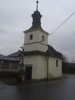 Chapel in the village | |
 Flag 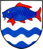 Coat of arms | |
 Bohuslavice | |
| Coordinates: 49°49′27″N 16°56′13″E / 49.82417°N 16.93694°ECoordinates: 49°49′27″N 16°56′13″E / 49.82417°N 16.93694°E | |
| Country | |
| Region | Olomouc |
| District | Šumperk |
| Area | |
| • Total | 3.97 km2 (1.53 sq mi) |
| Population | |
| • Total | 460 |
| • Density | 120/km2 (300/sq mi) |
| Postal code | 78972 |
| Website | http://www.bohuslavice.cz/ |

Bohuslavice (German: Bohuslawitz) is a village and municipality (obec) in Šumperk District in the Olomouc Region of the Czech Republic.
The municipality covers an area of 3.97 square kilometres (1.53 sq mi), and has a population of 460.
Bohuslavice lies approximately 16 kilometres (10 mi) south of Šumperk, 35 km (22 mi) north-west of Olomouc, and 183 km (114 mi) east of Prague.
Coat of arms of the village, a fish, refers to several local ponds which has been dried in the 19th century.
History[]
First written note about the village comes from 1536. First half of the village was owned by Zábřeh manor, second one by Zvole manor. Bohuslavice was totally destroyed during events of the Thirty Years War. New settlers probably came in 1677. The village suffered several major floods during its history as it is located in flood plain of the Morava River. In 1848, the village was in its entirety absorbed into the Zábřeh District.
The village was ceded to Nazi Germany after the Munich Agreement, and incorporated into the Reichsgau Sudetenland, even though the village was entirely ethnically Czech. Two Bohuslavice natives were killed fighting in with the Czech Army in Exile during World War II - Josef Kutal died during the Siege of Tobruk and Hynek Voráč died during the Battle of Sokolovo.
References[]
| Wikimedia Commons has media related to Bohuslavice (Šumperk District). |
| Authority control: National libraries |
|---|
This Olomouc Region location article is a stub. You can help Wikipedia by . |
- Villages in Šumperk District
- Olomouc Region geography stubs