Loučná nad Desnou
Loučná nad Desnou | |
|---|---|
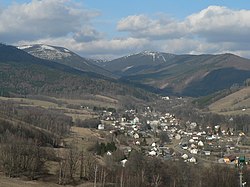 Upper part of Loučná nad Desnou | |
 Flag  Coat of arms | |
 Loučná nad Desnou Location in the Czech Republic | |
| Coordinates: 50°4′18″N 17°5′28″E / 50.07167°N 17.09111°ECoordinates: 50°4′18″N 17°5′28″E / 50.07167°N 17.09111°E | |
| Country | |
| Region | Olomouc |
| District | Šumperk |
| First mentioned | 1494 |
| Area | |
| • Total | 94.34 km2 (36.42 sq mi) |
| Elevation | 450 m (1,480 ft) |
| Population (2020-01-01[1]) | |
| • Total | 1,525 |
| • Density | 16/km2 (42/sq mi) |
| Time zone | UTC+1 (CET) |
| • Summer (DST) | UTC+2 (CEST) |
| Postal code | 788 11 |
| Website | www |

Loučná nad Desnou (until 1948 Vízmberk, German: Wiesenberg) is a municipality and village in Šumperk District in the Olomouc Region of the Czech Republic. It has about 1,500 inhabitants. It lies in the Hrubý Jeseník mountain range, in the Desná River valley.
Loučná nad Desnou lies approximately 15 kilometres (9 mi) north-east of Šumperk, 55 km (34 mi) north of Olomouc, and 191 km (119 mi) east of Prague.
Administrative parts[]
Villages of Filipová, Kociánov, Kouty nad Desnou, Přemyslov and Rejhotice are administrative parts of Loučná nad Desnou.
Notable people[]
- Alfred Brendel (born 1931), Austrian pianist
References[]
- ^ "Population of Municipalities – 1 January 2020". Czech Statistical Office. 2020-04-30.
| Wikimedia Commons has media related to Loučná nad Desnou. |
| show Authority control |
|---|
This Olomouc Region location article is a stub. You can help Wikipedia by . |
Categories:
- Villages in Šumperk District
- Olomouc Region geography stubs