Staré Město (Šumperk District)
Staré Město | |
|---|---|
Town | |
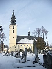
 Church of Saint Anne and the town hall | |
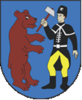 Coat of arms | |
 Staré Město Location in the Czech Republic | |
| Coordinates: 50°10′14″N 16°57′18″E / 50.17056°N 16.95500°ECoordinates: 50°10′14″N 16°57′18″E / 50.17056°N 16.95500°E | |
| Country | |
| Region | Olomouc |
| District | Šumperk |
| Founded | 13th century |
| Government | |
| • Mayor | Jiří Kamp |
| Area | |
| • Total | 86.3 km2 (33.3 sq mi) |
| Elevation | 538 m (1,765 ft) |
| Population (2020-01-01[1]) | |
| • Total | 1,712 |
| • Density | 20/km2 (51/sq mi) |
| Time zone | UTC+1 (CET) |
| • Summer (DST) | UTC+2 (CEST) |
| Postal code | 788 32 |
| Website | www |

Staré Město (German: Mährisch Altstadt) is a small town in Šumperk District in the Olomouc Region of the Czech Republic. It has about 1,700 inhabitants.
Administrative parts[]

Villages of Chrastice, Kunčice, Nová Seninka and Stříbrnice are administrative parts of Staré Město.
Etymology[]
A first settlement was founded by German colonists in the 13th century, when the village was mentioned as Goldeck ("Gold Corner") for its gold and silver mines. The town has been referred to as Altstadt ("Old Town") since the 15th century. The Czech name "Staré Město" is a loan translation of the German denotation.
The unofficial name of the town and official name of the town's train station is "Staré Město pod Králickým Sněžníkem" to distinguish it from other places called Staré Město.
Geography[]
The town is situated in the far northwest of the historic Moravia region, at the upper end of the wide Krupá valley. It lies on the southeastern slopes of two mountain ranges – the Śnieżnik Mountains and the Golden Mountains of the Eastern Sudetes, which form the border with Poland. The Králický Sněžník peak lies about 12 km (7.5 mi) northwest of the town, outside of the municipal area.
The Polish border is accessible via 815 m (2,674 ft) high Kladsko Pass (Kladské sedlo), where the road leads downhill into the Kłodzko Valley. Paved road is not widely used and its construction has not brought the expected rise of tourism from Poland.
History[]
The rich gold and silver deposits caused a steep rise of population. In 1336 Goldeck was elevated to the status of a royal mining community by King John of Bohemia, the exploited metal was used for minting the Prague groschen. However, the deposits were mostly depleted around the 15th century. Moreover, the town was occupied by Hussite warriors in 1423 and totally destroyed in 1438 and again in 1480 by the local lord John Tunkl of Brníčko. These disasters finished the period of prosperity; the mines were abandoned.
Lord Václav of Zvole supported developing of linen crafts in a half of the 16th century. His efforts were ruined in the Thirty Years' War, when Swedish soldiers burned parts of town down. However Altstadt recovered quickly and was established as a traditional local centre of a linen manufacturing during the 17th and 18th centuries. It became a border town, when the Prussian king Frederick the Great conquered the Silesian and Kladsko lands in the north during his Silesian campaign of 1740–42.
In the 19th century the Buhl family of entrepreneurs founded a small factory processing flax and even cotton. Also enormous deposits of graphite were discovered, and Buhl was one of the first mining investors. Graphite was the most important product of Staré Město until 1977 when the last major mine was closed, however the mining kept on going up to the year 2011. A branch railway line along the Krupá and Morava Rivers down to Hanušovice opened in 1905, served by the Imperial Royal Austrian State Railways. A small antimony quarry was opened in the 1920s, which however existed only for short time.
After the establishment of the First Czechoslovak Republic in 1918, the town was strongly militarized in the interwar period due to its strategic position near the German border at Kladsko Pass. The Czechoslovak administration considered parts of the local German-speaking population as disloyal, wherefore public life was supervised by Czech officials and police. A visit of the nearby woods was able only with permission. This special regime caused strong anti-Czechoslovak moods, which increased after the Machtergreifung of the Nazi Party in Germany in 1933 and the rise of the Sudeten German Party under Konrad Henlein openly demanding secession. The "Pevnost Kronfelzov" (Fort Kronfelzov) was one of the biggest projects of the Czechoslovak border fortifications, until works were interrupted by the 1938 Munich Agreement resulting in German occupation. During World War II the town in Sudetenland was incorporated into Nazi Germany and its citizens had to serve in the Wehrmacht forces.
All German town population was expelled in 1945. Abandoned houses were inhabited by Czech settlers from inner Bohemia, Moravia and Slovakia, by minorities from Volhynia and by refugees from the Greek civil war. The region of Staré Město lost its strategic military position as the former German territories in the northwest fell to Poland, therefore nearby woods could be exploited. The Communist regime nationalized farming and mining as well as manufacturing in 1948. Planned economy and new heterogeneous population, mostly without education, has made strong ongoing decay. New job opportunities were created in a paper industry. The town was occupied by Polish People’s Army troops in 1968, later replaced by Soviet Army forces. Small bases were established in the town's outskirts.
The Czechoslovak Velvet Revolution in 1989 and the later economic transformation again caused national economic recession. The Staré Město region was hit heavily, when unproductive mammoth state concerns weren’t able to survive in market economy. The textile industry collapsed, the paper industry reduced production. The unemployment is the biggest problem of the region up to today.
Demography[]
Demographically it is a typical Czech municipality – a strong Czech majority with a small Roma community. Foreigner immigrants from the 1940s and 50's are fully assimilated.
- 1869 – 4,903 people in 778 houses
- 1930 – 4,729 people in 941 houses
- 1950 – 2,636 people in 702 houses
- 1980 – 2,169 people in 357 houses
- 2001 – 2,145 people in 433 houses
- 2011 – 1,735 people in 460 houses
Economy[]

The unemployment rate was 5.3% in August 2020.[2] The most important sector is tourism service. Several ski resorts are very close to the town. Another important economic sector is the growing of bioproducts and forestry.
Rests of the graphite deposits are not recently mined. A successor of the former state-owned mining company bankrupted in 2011.[3]
Sights[]
The main tourist attraction are the Church of Saint Anne, the Rennaisance town hall and remnants of the military fortifications. A museum is situated in the former military base, which also preserves the abandoned interwar forts.
Culture[]
The town has a cinema and an amateur theatre group. An annual event is the BioFest, a music festival focused on "bio-living" with local bio farms presentation. The Staré Město community house is irregularly used for music production, lectures and hobby clubs.
Twin towns – sister cities[]
Staré Město is twinned with:[4]
 Stronie Śląskie, Poland
References[]
- ^ "Population of Municipalities – 1 January 2020". Czech Statistical Office. 2020-04-30.
- ^ "Nezaměstnanost v obcích od března 2014". Ministerstvo práce a sociálních věcí. Retrieved 2020-10-12.
- ^ "Grafitové doly Staré Město, a.s. "v likvidaci", Ostrava IČO 64619583 - Obchodní rejstřík firem".
- ^ "Program rozvoje města Staré Město na roky 2016–2030" (PDF). mu-staremesto.cz (in Czech). Město Staré Město. 2015. p. 21. Retrieved 2020-10-12.
External links[]
| Wikimedia Commons has media related to Staré Město (Šumperk District). |
| Authority control: National libraries |
|---|
- Cities and towns in the Czech Republic
- Populated places in Šumperk District