Petrov nad Desnou
Petrov nad Desnou | |
|---|---|
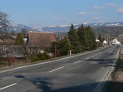 Road no. 11, Hrubý Jeseník in the background | |
 Flag  Coat of arms | |
 Petrov nad Desnou Location in the Czech Republic | |
| Coordinates: 50°0′20″N 17°2′40″E / 50.00556°N 17.04444°ECoordinates: 50°0′20″N 17°2′40″E / 50.00556°N 17.04444°E | |
| Country | |
| Region | Olomouc |
| District | Šumperk |
| First mentioned | 1354 |
| Area | |
| • Total | 12.20 km2 (4.71 sq mi) |
| Elevation | 365 m (1,198 ft) |
| Population (2020-01-01[1]) | |
| • Total | 1,220 |
| • Density | 100/km2 (260/sq mi) |
| Time zone | UTC+1 (CET) |
| • Summer (DST) | UTC+2 (CEST) |
| Postal code | 788 14, 788 16 |
| Website | www |

Petrov nad Desnou (until 1955 Petrovice nad Desnou, (German: Petersdorf an der Tess) is a municipality and village in Šumperk District in the Olomouc Region of the Czech Republic. It has about 1,200 inhabitants. It lies on the Desná River.
Petrov nad Desnou lies approximately 7 kilometres (4 mi) north-east of Šumperk, 48 km (30 mi) north-west of Olomouc, and 189 km (117 mi) east of Prague.
Administrative parts[]
Village of Terezín is an administrative part of Petrov nad Desnou.
History[]
From 1980 to 2009 the village was part of the municipality Sobotín. On 1 January 2010 Petrov nad Desnou became separate municipality.
References[]
- ^ "Population of Municipalities – 1 January 2020". Czech Statistical Office. 30 April 2020.
| Wikimedia Commons has media related to Petrov nad Desnou. |
| Authority control: National libraries |
|---|
This Olomouc Region location article is a stub. You can help Wikipedia by . |
Categories:
- Villages in Šumperk District
- Olomouc Region geography stubs