Bolešiny
Bolešiny | |
|---|---|
 Bus stop and a chapel | |
 Flag  Coat of arms | |
 Bolešiny Location in the Czech Republic | |
| Coordinates: 49°24′36″N 13°21′42″E / 49.41000°N 13.36167°ECoordinates: 49°24′36″N 13°21′42″E / 49.41000°N 13.36167°E | |
| Country | |
| Region | Plzeň |
| District | Klatovy |
| First mentioned | 1524 |
| Area | |
| • Total | 15.66 km2 (6.05 sq mi) |
| Elevation | 422 m (1,385 ft) |
| Population (2021-01-01)[1] | |
| • Total | 776 |
| • Density | 50/km2 (130/sq mi) |
| Time zone | UTC+1 (CET) |
| • Summer (DST) | UTC+2 (CEST) |
| Postal code | 339 01 |
| Website | www |

Bolešiny is a municipality and village in Klatovy District in the Plzeň Region of the Czech Republic. It has about 800 inhabitants.
Bolešiny lies approximately 6 kilometres (4 mi) east of Klatovy, 38 km (24 mi) south of Plzeň, and 108 km (67 mi) south-west of Prague.
Administrative parts[]
Villages of Domažličky, Kroměždice, Pečetín, Slavošovice and Újezdec are administrative parts of Bolešiny.
Gallery[]
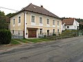
Houses
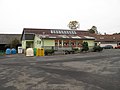
A shop

Common in Bolešiny


References[]
| Wikimedia Commons has media related to Bolešiny. |
| Authority control: National libraries |
|---|
This Plzeň Region location article is a stub. You can help Wikipedia by . |
Categories:
- Villages in Klatovy District
- Plzeň Region geography stubs