Prášily
Prášily | |
|---|---|
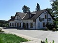
 Entering Prášily from the direction of Srní | |
 Coat of arms | |
 Prášily Location in the Czech Republic | |
| Coordinates: 49°6′19″N 13°22′41″E / 49.10528°N 13.37806°ECoordinates: 49°6′19″N 13°22′41″E / 49.10528°N 13.37806°E | |
| Country | |
| Region | Plzeň |
| District | Klatovy |
| Founded | 1732 |
| Area | |
| • Total | 112.33 km2 (43.37 sq mi) |
| Elevation | 880 m (2,890 ft) |
| Population (2021-01-01)[1] | |
| • Total | 154 |
| • Density | 1.4/km2 (3.6/sq mi) |
| Time zone | UTC+1 (CET) |
| • Summer (DST) | UTC+2 (CEST) |
| Postal code | 342 01 |
| Website | www |

Prášily (German: Stubenbach) is a municipality and village in Klatovy District in the Plzeň Region of the Czech Republic. It has about 200 inhabitants.
Administrative parts[]
The village of Nová Hůrka is an administrative part of Prášily.
Geography[]
Prášily lies in the Bohemian Forest, approximately 34 kilometres (21 mi) south of Klatovy, 72 km (45 mi) south of Plzeň, and 132 km (82 mi) south-west of Prague.
With the area of 112.33 km2 it is the largest municipality in the country without town status by size, even though most of Prášily's territory is covered by forests.[2]
Notable people[]
- Gunther of Bohemia (c. 955–1045), Catholic hermit and diplomat; died in the hermitage on Březník mountain
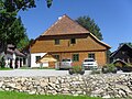
Gallery[]

Sweetshop "Pampeliška"
"Hostinec u Michala" inn
"Brücknerův dům" (Brückner House)

Memorial of villages destroyed by Czechoslovak army in 1950s

Classic local timber house


References[]
- ^ "Population of Municipalities – 1 January 2021". Czech Statistical Office. 2021-04-30.
- ^ Hejna, Petr (23 October 2017). "Šumavské Prášily oplývají četnými zajímavostmi i drží několik prvenství". Novinky.cz.
External links[]
| Wikimedia Commons has media related to Prášily. |
| show Authority control |
|---|
This Plzeň Region location article is a stub. You can help Wikipedia by . |
- Villages in Klatovy District
- Bohemian Forest
- Plzeň Region geography stubs