Dolany (Klatovy District)
Dolany | |
|---|---|
 Centre of Dolany | |
 Flag  Coat of arms | |
 Dolany Location in the Czech Republic | |
| Coordinates: 49°26′36″N 13°14′53″E / 49.44333°N 13.24806°ECoordinates: 49°26′36″N 13°14′53″E / 49.44333°N 13.24806°E | |
| Country | |
| Region | Plzeň |
| District | Klatovy |
| First mentioned | 1232 |
| Area | |
| • Total | 25.29 km2 (9.76 sq mi) |
| Elevation | 387 m (1,270 ft) |
| Population (2021-01-01)[1] | |
| • Total | 939 |
| • Density | 37/km2 (96/sq mi) |
| Time zone | UTC+1 (CET) |
| • Summer (DST) | UTC+2 (CEST) |
| Postal code | 339 01 |
| Website | www |

Dolany is a municipality and village in Klatovy District in the Plzeň Region of the Czech Republic. It has about 900 inhabitants.
Dolany lies approximately 7 kilometres (4 mi) north-west of Klatovy, 35 km (22 mi) south of Plzeň, and 111 km (69 mi) south-west of Prague.
Administrative parts[]
Villages of Andělice, Balkovy, Komošín, Malechov, Řakom, Sekrýt, Svrčovec and Výrov are administrative parts of Dolany.
Gallery[]

Church of Saint Peter and Paul

Fortress ruin in Dolany
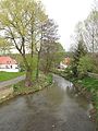
Poleňka stream


References[]
| Wikimedia Commons has media related to Dolany (Klatovy District). |
| Authority control: National libraries |
|---|
This Plzeň Region location article is a stub. You can help Wikipedia by . |
Categories:
- Villages in Klatovy District
- Plzeň Region geography stubs