Brea, California
Brea, California | |
|---|---|
City | |
| City of Brea | |
 Market City Cafe in Brea downtown | |
 Seal | |
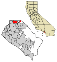 Location of Brea in Orange County, California. | |
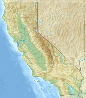 Brea Location within the state of California | |
| Coordinates: 33°55′24″N 117°53′20″W / 33.92333°N 117.88889°WCoordinates: 33°55′24″N 117°53′20″W / 33.92333°N 117.88889°W | |
| Country | United States |
| State | California |
| County | Orange |
| Incorporated | February 23, 1917[4] |
| Named for | Spanish for "natural asphalt" or "tar" |
| Government | |
| • City Council[1] | Mayor Christine Marick Mayor Pro Tem Marty Simonoff Steven Vargas Glenn Parker Cecilia Hupp |
| • City treasurer | Rick Rios [2] |
| • City manager | Bill Gallardo[3] |
| Area | |
| • Total | 12.21 sq mi (31.62 km2) |
| • Land | 12.17 sq mi (31.52 km2) |
| • Water | 0.04 sq mi (0.10 km2) 0.26% |
| Elevation | 361 ft (110 m) |
| Population | |
| • Total | 39,282 |
| • Estimate (2019)[8] | 43,255 |
| • Density | 3,554.52/sq mi (1,372.37/km2) |
| Time zone | UTC−8 (PST) |
| • Summer (DST) | UTC−7 (PDT) |
| ZIP codes | 92821–92823 |
| Area codes | 657/714, 562 |
| FIPS code | 06-08100 |
| GNIS feature IDs | 1660373, 2409897 |
| Website | www |


Brea (/ˈbreɪə/;[9] meaning 'oil' or 'tar' in Spanish) is a city in northern Orange County, California. The population as of the 2010 census was 39,282. It is 33 miles (53 km) southeast of Los Angeles. Brea is part of the Los Angeles metropolitan area.
The city began as a center of crude oil production, was later propelled by citrus production, and is now an important retail center because of the large Brea Mall and the recently redeveloped Brea Downtown. Brea is also known for its extensive public art program which began in 1975 and continues today with over 140 artworks in the collection placed and located throughout the city.[citation needed] Brea's public art program has been used as a model and inspiration for many public art programs across the United States.[citation needed]
History[]
The area was visited on July 29, 1769, by the Spanish Portolá expedition – the first Europeans to see inland parts of Alta California. The party camped in Brea Canyon, near a large native village and a small pool of clean water.[10] A historical marker dedicated to his visit stands in Brea Canyon just north of town.

The village of Olinda was founded in present-day Carbon Canyon at the beginning of the 19th century and many entrepreneurs came to the area searching for "black gold" (petroleum). In 1894, the owner of the land, Abel Stearns, sold 1,200 acres (4.9 km2) west of Olinda to the newly created Union Oil Company of California, and by 1898 many nearby hills began sporting wooden oil drilling towers on the newly discovered Brea-Olinda Oil Field. In 1908 the village of Randolph, named for railway engineer Epes Randolph, was founded just south of Brea Canyon for oil workers and their families. Baseball legend Walter Johnson grew up in Olinda at the start of the 20th century where he worked in the surrounding oil fields as a youth.[11]
The villages of Olinda and Randolph grew and merged as the economy boomed. On January 19, 1911, the town's map was filed under the new name of Brea, from the Spanish language word for natural asphalt, also called bitumen, pitch or tar. With a population of 752, Brea was incorporated on February 23, 1917, as the eighth official city of Orange County.
As oil production declined, some agricultural development took place, especially lemon and orange groves. In the 1920s, the Brea Chamber of Commerce promoted the city with the slogan “Oil, Oranges, and Opportunity.”[12] In 1950 Brea had a population of 3,208. The citrus groves gave way gradually to industrial parks and residential development. In 1956, Carl N. Karcher opened the first two Carl's Jr. restaurants in Anaheim, California and Brea, California. The opening of the Orange Freeway (57) and the Brea Mall in the 1970s spurred further residential growth, including large planned developments east of the 57 Freeway in the 1980s, 1990s, and 2000s. In the late 1990s, a 50-acre (200,000 m2) swath of downtown Brea centered on Brea Boulevard and Birch Street was heavily redeveloped into a shopping and entertainment area with movie theaters, sidewalk cafes, a live comedy club from The Improv chain, numerous shops and restaurants, and a weekly farmer's market. It is locally known and signed as Downtown Brea.
Sunset magazine named Brea one of the five best suburbs to live in the Western United States in early 2006.[13]
Geography[]
According to the United States Census Bureau, the city has an area of 12.1 square miles (31 km2). 12.1 square miles (31 km2) of it is land and 0.26% is water.
It is bordered by unincorporated Orange County and Los Angeles County to the north and east, La Habra to the west, Fullerton to the southwest, Placentia to the south, and Yorba Linda to the southeast.
Climate[]
According to the Köppen Climate Classification system, Brea has a hot-summer Mediterranean climate, abbreviated "Csa" on climate maps.[14]
| hideClimate data for Brea, California | |||||||||||||
|---|---|---|---|---|---|---|---|---|---|---|---|---|---|
| Month | Jan | Feb | Mar | Apr | May | Jun | Jul | Aug | Sep | Oct | Nov | Dec | Year |
| Average high °C (°F) | 21 (69) |
21 (70) |
22 (72) |
23 (74) |
24 (76) |
27 (80) |
29 (85) |
30 (86) |
30 (86) |
27 (81) |
24 (75) |
21 (69) |
25 (77) |
| Average low °C (°F) | 8 (47) |
9 (48) |
10 (50) |
11 (52) |
14 (57) |
16 (60) |
18 (64) |
18 (64) |
17 (62) |
14 (57) |
11 (51) |
8 (46) |
13 (55) |
| Average precipitation mm (inches) | 64 (2.5) |
79 (3.1) |
69 (2.7) |
28 (1.1) |
5.1 (0.2) |
0 (0) |
0 (0) |
10 (0.4) |
7.6 (0.3) |
7.6 (0.3) |
30 (1.2) |
61 (2.4) |
361.3 (14.2) |
| [citation needed] | |||||||||||||
Government[]

Local[]
Brea is governed by a council-manager system. The five member city council is elected for four-year terms in elections every two years to fill alternately two and three seats.[15] The council is made up of the mayor, the mayor pro tem and three councilmembers.[16] The council elects a mayor from the serving councilmembers to serve a one-year term as mayor. The city council hires a city manager to direct the city's departments and advise the council. The council appoints members of the Planning Commission; Parks, Recreation and Human Services Commission; Cultural Arts Commission, and Traffic Committee.[15]
City services[]
Fire protection for Brea is provided by the Brea Fire Department (BFD)[17] and law enforcement is provided by the Brea Police Department. Within Carbon Canyon,[18] in the Olinda neighborhood of Brea,[19] is situated Olinda Landfill,[20] a major waste management facility serving a large part of Orange County.[21]
Management of the city and coordination of city services is provided by:[22]
State and federal representation[]
In the California State Legislature, Brea is in the 29th Senate District, represented by Democrat Josh Newman, and in the 55th Assembly District, represented by Republican Phillip Chen.[23]
In the United States House of Representatives, Brea is in California's 39th congressional district, represented by Republican Young Kim.[24]
Demographics[]
| Historical population | |||
|---|---|---|---|
| Census | Pop. | %± | |
| 1920 | 1,037 | — | |
| 1930 | 2,435 | 134.8% | |
| 1940 | 2,567 | 5.4% | |
| 1950 | 3,208 | 25.0% | |
| 1960 | 8,487 | 164.6% | |
| 1970 | 18,447 | 117.4% | |
| 1980 | 27,913 | 51.3% | |
| 1990 | 32,873 | 17.8% | |
| 2000 | 35,410 | 7.7% | |
| 2010 | 39,282 | 10.9% | |
| 2019 (est.) | 43,255 | [8] | 10.1% |
| U.S. Decennial Census[25] | |||
2010[]
The 2010 United States Census[26] reported that Brea had a population of 39,282. The population density was 3,243.9 people per square mile (1,252.5/km2). The racial makeup of Brea was 26,363 (67.1%) White (52.7% Non-Hispanic White),[27] 549 (1.4%) African American,190 (0.5%) Native American, 7,144 (18.2%) Asian, 69 (0.2%) Pacific Islander, 3,236 (8.2%) from other races, and 1,731 (4.4%) from two or more races. Hispanic or Latino of any race were 9,817 persons (25.0%).
The census reported that 39,213 people (99.8% of the population) lived in households, 69 (0.2%) lived in non-institutionalized group quarters, and 0 (0%) were institutionalized.
There were 14,266 households, out of which 5,043 (35.3%) had children under the age of 18 living in them, 8,132 (57.0%) were opposite-sex married couples living together, 1,605 (11.3%) had a female householder with no husband present, 632 (4.4%) had a male householder with no wife present. There were 569 (4.0%) unmarried opposite-sex partnerships, and 100 (0.7%) same-sex married couples or partnerships. 3,070 households (21.5%) were made up of individuals, and 1,265 (8.9%) had someone living alone who was 65 years of age or older. The average household size was 2.75. There were 10,369 families (72.7% of all households); the average family size was 3.23.
The population was spread out, with 9,057 people (23.1%) under the age of 18, 3,654 people (9.3%) aged 18 to 24, 10,669 people (27.2%) aged 25 to 44, 10,952 people (27.9%) aged 45 to 64, and 4,950 people (12.6%) who were 65 years of age or older. The median age was 38.7 years. For every 100 females, there were 95.2 males. For every 100 females age 18 and over, there were 91.9 males.
There were 14,785 housing units at an average density of 1,221.0 per square mile (471.4/km2), of which 9,266 (65.0%) were owner-occupied, and 5,000 (35.0%) were occupied by renters. The homeowner vacancy rate was 1.3%; the rental vacancy rate was 5.3%. 26,889 people (68.5% of the population) lived in owner-occupied housing units and 12,324 people (31.4%) lived in rental housing units.
According to the 2010 United States Census, Brea had a median household income of $82,055, with 5.6% of the population living below the federal poverty line.[27]
2000[]
There were 13,067 households, out of which 34.6% had children under the age of 18 living with them, 56.6% were married couples living together, 10.5% had a female householder with no husband present, and 28.8% were non-families. 23.0% of all households were made up of individuals, and 8.5% had someone living alone who was 65 years of age or older. The average household size was 2.70 and the average family size was 3.21.
In the city, the population was spread out, with 25.6% under the age of 18, 8.5% from 18 to 24, 30.4% from 25 to 44, 24.1% from 45 to 64, and 11.4% who were 65 years of age or older. The median age was 36 years. For every 100 females, there were 95.3 males. For every 100 females age 18 and over, there were 91.9 males.
The median income for a household in the city was $64,820, and the median income for a family was $68,423. Males had a median income of $50,500 versus $35,674 for females. The per capita income for the city was $26,307. About 3.4% of families and 5.3% of the population were below the poverty line, including 6.7% of those under age 18 and 5.2% of those age 65 or over.
Politics[]
Brea is traditionally a Republican stronghold at the presidential level; however, Democratic candidate Joe Biden carried the city in 2020.[citation needed] According to the California Secretary of State, as of October 22, 2018, Brea has 24,775 registered voters. Of those, 9,991 (40.33%) are registered Republicans, 7,370 (29.75%) are registered Democrats, and 6,466 (26.10%) have declined to state a political party or are independents.[28]
| Year | Democratic | Republican | Third Parties |
|---|---|---|---|
| 2020[29] | 50.52% 12,801 | 47.54% 12,046 | 1.95% 493 |
| 2016[30] | 44.55% 8,724 | 48.17% 9,432 | 7.28% 1,426 |
| 2012[31] | 39.66% 7,197 | 57.89% 10,504 | 2.45% 444 |
| 2008[32] | 41.70% 7,625 | 56.26% 10,287 | 2.05% 374 |
| 2004[33] | 33.35% 5,722 | 65.56% 11,248 | 1.08% 186 |
| 2000[34] | 34.59% 5,408 | 61.71% 9,649 | 3.70% 579 |
| 1996[35] | 34.70% 4,931 | 55.40% 7,872 | 9.90% 1,407 |
| 1992[36] | 28.91% 4,686 | 48.09% 7,796 | 23.00% 3,728 |
| 1988[37] | 27.82% 4,061 | 71.06% 10,372 | 1.12% 164 |
| 1984[38] | 21.26% 2,976 | 77.96% 10,913 | 0.79% 110 |
| 1980[39] | 20.79% 2,660 | 71.03% 9,088 | 8.18% 1,046 |
| 1976[40] | 33.24% 2,983 | 65.24% 5,855 | 1.48% 133 |
Economy[]
Top employers[]
According to the city's 2019 Comprehensive Annual Financial Report,[41] the top employers in the city are:
| # | Employer | # of employees |
|---|---|---|
| 1 | Bank of America | 3,000 |
| 2 | Mercury Insurance Group | 1,440 |
| 3 | Albertsons | 1,321 |
| 4 | Beckman Coulter | 906 |
| 5 | Brea Olinda Unified School District | 713 |
| 6 | Kirkhill - TA Company | 638 |
| 7 | Nationwide Mutual Insurance Company | 460 |
| 8 | Bristol Industries | 435 |
| 9 | Zodiac Inflight Innovations | 390 |
| 10 | Peterson Brothers Construction | 375 |
Education[]
The city is primarily served by the Brea Olinda Unified School District which operates six elementary schools, one junior high school (), one high school (Brea Olinda High School) and one continuation high school. A small portion of Brea is also directed to Sonora High School in La Habra in the Fullerton Joint Union High School District. That small portion is also directed to the La Habra City School District. In addition, students can also take an assessment to place in nearby Troy High School in Fullerton, also part of the Fullerton High School District.
There are many private schools in Brea, the Brea Head Start (Pre) Brea Olinda Friends School (Pre-6), Brea Congregational Pre-School, Brea Foursquare Church (Pre-5), Brea United Methodist Pre-School ("BUMPS"), Carbon Canyon Christian School (K-12), Christ Lutheran School (Pre-8), St. Angela Merici Parish School (TK-8), and Montessori of Brea (K-6). Brea is also home to the Southern California College of Business and Law and the Southern California extension of Golden Gate Baptist Theological Seminary.
School awards[]

Local schools have won several awards. Brea Olinda High School and Olinda Elementary School have been named Blue Ribbon Schools. Additionally, Arovista Elementary, Country Hills Elementary, Fanning Elementary, Mariposa Elementary, Olinda Elementary, Brea Junior High and Brea Olinda High schools have been named California Distinguished Schools.[42] Laurel Elementary received a Title I Academic Achievement Award. Brea Junior High School and Brea Olinda High School have been named California Gold Ribbon Schools.[43]
Notable people[]
- Cody Fajardo, Quarterback for the Saskatchewan Roughriders
- Stephanie J. Block, Broadway actress/singer
- James Cameron, film director/producer/screenwriter
- JoAnn Dean Killingsworth, actress & dancer, first person to play Snow White at Disneyland[44]
- Travis Denker, Major League baseball player (San Francisco Giants)
- Kyle Fogg, professional basketball player
- Tommy Gallarda, Pro Football player (Atlanta Falcons)
- James Hetfield, musician (Metallica)
- Walter Johnson, Major League baseball pitcher for the Washington Senators
- Randy Jones, Major League baseball player (San Diego Padres)
- Joe Maddon, Major League baseball manager (Chicago Cubs)
- Alli Mauzey, Broadway actress/singer
- John McEntee, political aide to Donald Trump
- Evan Moore, Pro Football player (Green Bay Packers)
- Jeanette Pohlen, Women's National Basketball Association player (Indiana Fever)
- Cruz Reynoso, jurist
- Caroline Zhang, figure skater
- Nikki Ziering, model and actress
- Norma Zimmer, singer
Sister cities[]
Brea is twinned with:[45]
References[]
- Hardy, Purl. History of Brea, California: From Early Oil Field Days to 1950.
- "History of Brea". Brea Chamber of Commerce. Archived from the original on October 22, 2006. Retrieved October 27, 2006.
- "My Orange County: Brea History". Archived from the original on February 7, 2005. Retrieved 2006. Check date values in:
|access-date=(help)
- ^ "City Council". Brea, CA. Retrieved June 3, 2019.
- ^ "City Treasurer". Brea, CA. Retrieved February 8, 2015.
- ^ "City Manager's Office". Brea, CA. Retrieved June 3, 2019.
- ^ "California Cities by Incorporation Date". California Association of Local Agency Formation Commissions. Archived from the original (Word) on November 3, 2014. Retrieved August 25, 2014.
- ^ "2019 U.S. Gazetteer Files". United States Census Bureau. Retrieved July 1, 2020.
- ^ "Brea". Geographic Names Information System. United States Geological Survey. Retrieved April 13, 2015.
- ^ "Brea QuickFacts". United States Census Bureau. Archived from the original on April 17, 2015. Retrieved April 8, 2015.
- ^ Jump up to: a b "Population and Housing Unit Estimates". United States Census Bureau. May 24, 2020. Retrieved May 27, 2020.
- ^ Gudde, Erwin G. (1998). California Place Names: The Origin and Etymology of Current Geographical Names (4th ed.). University of California Press. p. 46. ISBN 978-0-520-26619-3.
- ^ Bolton, Herbert E. (1927). Fray Juan Crespi: Missionary Explorer on the Pacific Coast, 1769-1774. HathiTrust Digital Library. pp. 142–143.
- ^ Dufresne, Chris (June 2, 2008). "The year the Big Train stopped in Brea, and brought the Babe". Los Angeles Times. Retrieved June 2, 2008.
- ^ "Brea Chamber History". Brea Chamber of Commerce. Archived from the original on September 14, 2016. Retrieved September 26, 2016.
- ^ "Brea Wins Acclaim, Best Place To Live". Sunset. Archived from the original on July 1, 2012. Retrieved August 5, 2007.
- ^ "Brea, California Travel Weather Averages (Weatherbase)". Weatherbase. Retrieved August 13, 2016.
- ^ Jump up to: a b "City Council". City of Brea. Archived from the original on October 11, 2006. Retrieved October 27, 2006.
- ^ "Brea City Council - 2005-2006". City of Brea. Archived from the original on October 26, 2006. Retrieved October 27, 2006.
- ^ "Fire Services". City of Brea. Archived from the original on October 26, 2006. Retrieved October 27, 2006.
- ^ Hills For Everyone - Friends of Puente-Chino Hills Wildlife Corridor. "Olinda Landfill at Hills For Everyone". Archived from the original on July 26, 2011. Retrieved December 30, 2010.
- ^ City of Brea. "Olinda Landfill at City of Brea official website". Archived from the original on March 11, 2011. Retrieved December 30, 2010.
- ^ California Department of Resources Recycling and Recovery (CalRecycle). "Olinda Landfill at CalRecycle". Archived from the original on August 3, 2010. Retrieved December 30, 2010.
- ^ Orange County Waste & Recycling Department. "Olinda Landfill at Orange County Waste & Recycling Department". Archived from the original on July 3, 2010. Retrieved December 30, 2010.
- ^ City of Brea Website Archived June 25, 2009, at the Wayback Machine. Retrieved August 26, 2015
- ^ "Statewide Database". UC Regents. Archived from the original on February 1, 2015. Retrieved December 14, 2014.
- ^ "California's 39th Congressional District - Representatives & District Map". Civic Impulse, LLC.
- ^ "Census of Population and Housing". Census.gov. Retrieved June 4, 2015.
- ^ "2010 Census Interactive Population Search: CA - Brea city". U.S. Census Bureau. Archived from the original on July 15, 2014. Retrieved July 12, 2014.
- ^ Jump up to: a b "Archived copy". Archived from the original on April 17, 2015. Retrieved December 12, 2013.CS1 maint: archived copy as title (link)
- ^ "CA Secretary of State – Report of Registration – October 22, 2018" (PDF). ca.gov. Retrieved February 16, 2019.
- ^ "Precinct results" (PDF). www.ocvote.com. 2020. Retrieved November 27, 2020.
- ^ https://www.ocvote.com/fileadmin/live/gen2016/sov.pdf
- ^ https://www.ocvote.com/fileadmin/live/gen2012/sov-for-web.pdf
- ^ https://www.ocvote.com/fileadmin/user_upload/sov/gen2008/sov.pdf
- ^ https://www.ocvote.com/fileadmin/user_upload/sov/e13/sov1.pdf
- ^ https://www.ocvote.com/fileadmin/user_upload/sov/gen2000/gen2000-SOV.pdf
- ^ California. Secretary of State (March 30, 1968). "Statement of vote". Sacramento, Calif. : The Secretary – via Internet Archive.
- ^ California. Secretary of State (March 30, 1968). "Statement of vote". Sacramento, Calif. : The Secretary – via Internet Archive.
- ^ Statement of the Vote. Sacramento, Calif. : The Secretary. 1968.
- ^ Statement of the Vote. Sacramento, Calif. : The Secretary. 1968.
- ^ Statement of the Vote. Sacramento, Calif. : The Secretary. 1968.
- ^ Statement of the Vote. Sacramento, Calif. : The Secretary. 1968.
- ^ "City of Brea CAFR". Archived from the original on April 4, 2020. Retrieved April 4, 2020.
- ^ Leal, Fermin (March 29, 2012). "42 O.C. schools named state's best". Orange County Register. Archived from the original on April 4, 2020. Retrieved April 4, 2020.
- ^ Whitehead, Brian (April 19, 2017). "29 Orange County schools receive California Gold Ribbon honors". Orange County Register. Archived from the original on April 4, 2020. Retrieved April 4, 2020.
- ^ Chawkins, Steve (June 25, 2015). "JoAnn Dean Killingsworth dies at 91; Disneyland's first Snow White". Los Angeles Times. Retrieved July 22, 2015.
- ^ "Brea Sister City Program". ci.brea.ca.us. City of Brea. Retrieved January 13, 2021.
External links[]
| Wikimedia Commons has media related to Brea, California. |
- Official website

- "Brea Downtown". June 20, 2019.
- "Brea Police Department". June 20, 2019.
- "Brea Fire Department". June 20, 2019.
- "Brea Olinda Unified School District". June 20, 2019.
- "Brea Soccer Association". Retrieved June 25, 2007.
- City Of Brea Art Gallery
| show Municipalities and communities of Orange County, California, United States |
|---|

| show Greater Los Angeles Area |
|---|

| show Authority control |
|---|
- Brea, California
- Cities in Orange County, California
- Incorporated cities and towns in California
- Populated places established in 1917
- 1917 establishments in California