British Cameroon
Coordinates: 6°N 10°E / 6°N 10°E

This article relies largely or entirely on a single source. (April 2012) |
British Cameroon | |||||||||||
|---|---|---|---|---|---|---|---|---|---|---|---|
| 1916–1961 | |||||||||||
| Anthem: God Save the King/Queen | |||||||||||
 | |||||||||||
| Status | Mandate of the United Kingdom | ||||||||||
| Capital | Buea | ||||||||||
| Common languages | English (official) Duaka, Oroko, Grassfields, Fula, Kanuri widely spoken | ||||||||||
| Religion | Christianity (southern area) Islam (northern area) | ||||||||||
| Historical era | World War I | ||||||||||
• Kamerun partitioned | July 20 1916 | ||||||||||
• Integration into Nigeria and Cameroon | October 1 1961 | ||||||||||
| Currency | British West Africa pound | ||||||||||
| ISO 3166 code | CM | ||||||||||
| |||||||||||
| Today part of | Cameroon Nigeria | ||||||||||


British Cameroon or British Cameroons was a British Mandate territory in British West Africa, formed of Northern Cameroons and Southern Cameroons. Today, Northern Cameroons forms parts of the Borno, Adamawa, and Taraba states of Nigeria,[1] and the Southern Cameroons now a part of Cameroon.[2]
History[]
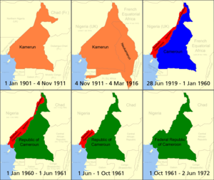
The area of present-day Cameroon was claimed by Germany as a protectorate during the "Scramble for Africa" at the end of the 19th century. The German Empire named the territory Kamerun.
League of Nations Mandate[]
During the First World War, it was occupied by British, French and Belgian troops, and a later League of Nations Mandate to Great Britain and France by the League of Nations in 1922. The French mandate was known as Cameroun and the British territory was administered as two areas, Northern Cameroons and Southern Cameroons. Northern Cameroons consisted of two non-contiguous sections, divided by a point where the Nigerian and Cameroun borders met. In the 1930s, most of the white population consisted of Germans, who were interned in British camps starting in June 1940. The native population of 400,000 showed little interest in volunteering for the British forces; only 3,500 men did so.[3]
Trust territory[]
When the League of Nations ceased to exist in 1946, most of the mandate territories were reclassified as UN trust territories, henceforth administered through the UN Trusteeship Council. The object of trusteeship was to prepare the lands for eventual independence. The United Nations approved the Trusteeship Agreements for British Cameroons to be governed by Britain on 6 December 1946.
Independence[]
French Cameroun became independent, as Cameroun or Cameroon, on January 1, 1960, and Nigeria was scheduled for independence later that same year, which raised question of what to do with the British territory. After some discussion (which had been going on since 1959), a plebiscite was agreed to and held on 11 February 1961. The Muslim-majority Northern area opted for union with Nigeria, and the Southern area voted to join Cameroon.[4]
Northern Cameroons became the Sardauna Province of Northern Nigeria[5] on 1 June 1961, while Southern Cameroons became West Cameroon, a constituent state of the Federal Republic of Cameroon, later that year on 1 October 1961.
Governors[]
See also[]
- Postage stamps and postal history of British Cameroons
References[]
- ^ El-Sudi, Ibrahim Tukur (2019-04-20). "The Nigerian States that Formed Parts of Northern Cameroons". PRNigeria News. Retrieved 2020-04-25.
- ^ Njung, George N. (2019-12-01). "The British Cameroons Mandate Regime: The Roots of the Twenty-First-Century Political Crisis in Cameroon". The American Historical Review. 124 (5): 1715–1722. doi:10.1093/ahr/rhz1025. ISSN 0002-8762.
- ^ I.C.B Dear, ed, The Oxford Companion to World War II (1995) p 163
- ^ Nohlen, D, Krennerich, M & Thibaut, B (1999) Elections in Africa: A data handbook, p177 ISBN 0-19-829645-2
- ^ Parties and Politics in Northern Nigeria, Routledge, 1968, page 155
External links[]
![]() Media related to British Cameroons at Wikimedia Commons
Media related to British Cameroons at Wikimedia Commons
- The road to the unitary state of Cameroon 1959-1972
- National Service Memoirs of a National Serviceman who served in the British Cameroons at the time of the vote to join with the French Cameroons or Nigeria
- Cameroons under British Administration Trusteeship Documents - UN Documentation: Trusteeship Council
Culture:Anglosphere | |||||||||||||||
| |||||||||||||||
| |||||||||||||||
| |||||||||||||||
| |||||||||||||||
| |||||||||||||||
| |||||||||||||||
| |||||||||||||||
| |||||||||||||||
Mandates of the League of Nations (1919–1946) | ||
|---|---|---|
| Class A |
|  |
| Class B |
| |
| Class C |
| |
See also: United Nations Trust Territories (post-1946) | ||
- British Cameroons
- British West Africa
- History of Cameroon
- History of Nigeria
- Former British colonies and protectorates in Africa
- League of Nations mandates
- United Nations trust territories
- Former British protectorates
- Former colonies in Africa
- Cameroon–United Kingdom relations
- Nigeria–United Kingdom relations
- 1922 establishments in the British Empire
- 1922 establishments in Africa
- 1961 disestablishments in Africa
- Former polities of the Cold War