Brownsburg, Indiana
hideThis article has multiple issues. Please help or discuss these issues on the talk page. (Learn how and when to remove these template messages)
|
Brownsburg, Indiana | |
|---|---|
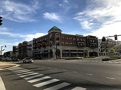 North Green Street | |
| Motto(s): "Community on the Move" | |
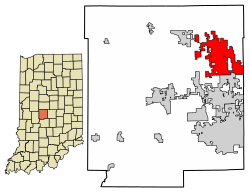 Location of Brownsburg in Hendricks County, Indiana. | |
| Coordinates: 39°50′31″N 86°23′44″W / 39.84194°N 86.39556°WCoordinates: 39°50′31″N 86°23′44″W / 39.84194°N 86.39556°W | |
| Country | United States |
| State | Indiana |
| County | Hendricks |
| Area | |
| • Total | 16.35 sq mi (42.36 km2) |
| • Land | 16.27 sq mi (42.13 km2) |
| • Water | 0.09 sq mi (0.22 km2) |
| Elevation | 879 ft (268 m) |
| Population | |
| • Total | 21,285 |
| • Estimate (2019)[3] | 27,001 |
| • Density | 1,659.76/sq mi (640.83/km2) |
| Time zone | UTC-5 (EST) |
| • Summer (DST) | UTC-4 (EDT) |
| ZIP code | 46112 |
| Area code(s) | 317 |
| FIPS code | 18-08416[4] |
| GNIS feature ID | 0431646[5] |
| Website | www |

Brownsburg is a town in Hendricks County, Indiana, United States. The population was 21,285 at the 2010 Census, an increase from 14,520 in 2000.[6] As of 2019 the estimated population was 27,001.[7]
History[]

Brownsburg was first settled in 1824 by James B. Brown. When he arrived, the area was a dense, unbroken stretch of wilderness. Delaware Indians lived in what is now called Lincoln Township, along White Lick Creek, which was then called "Wa-pe-ke-way" or "White Salt".
Four years later, the first log schoolhouse built in Brown Township. Once a stagecoach line was established along a road built in 1820 connecting to Indianapolis, more settlers arrived. William Harris settled in the area north of what is now Main Street, selling sections of woods to incoming pioneers which gave the town its original name of Harrisburg in 1835. A post office was established in 1836 under the name of Harrisburg, but was later changed to Brownsburg since the name Harrisburg was being used by a post office in another Indiana county.
Brownsburg tripled in size from 1840 to 1870, increased from six to sixteen acres, and added its first church. The town's first election was held in 1848. In 1863, it was divided into Brown Township and Lincoln Township.[8]
In 1985, part of the movie Hoosiers was filmed in the former College Avenue Gym.[9]

Geography[]
According to the 2010 census, Brownsburg has a total area of 11.16 square miles (28.90 km2), of which 11.08 square miles (28.70 km2) (or 99.28%) is land and 0.08 square miles (0.21 km2) (or 0.72%) is water.[10][11] White Lick Creek, a tributary of the White River, flows from north to south through the town, passing just west of the town center.
Demographics[]
| Historical population | |||
|---|---|---|---|
| Census | Pop. | %± | |
| 1850 | 132 | — | |
| 1870 | 551 | — | |
| 1880 | 667 | 21.1% | |
| 1890 | 623 | −6.6% | |
| 1900 | 676 | 8.5% | |
| 1910 | 876 | 29.6% | |
| 1920 | 1,063 | 21.3% | |
| 1930 | 1,042 | −2.0% | |
| 1940 | 1,136 | 9.0% | |
| 1950 | 1,578 | 38.9% | |
| 1960 | 4,478 | 183.8% | |
| 1970 | 5,751 | 28.4% | |
| 1980 | 6,242 | 8.5% | |
| 1990 | 7,628 | 22.2% | |
| 2000 | 14,520 | 90.4% | |
| 2010 | 21,285 | 46.6% | |
| 2019 (est.) | 27,001 | [3] | 26.9% |
| Source: US Census Bureau | |||
2010 census[]
At the 2010 census there were 21,285 people, 7,948 households, and 5,816 families in the town. The population density was 1,921.0 inhabitants per square mile (741.7/km2). There were 8,376 housing units at an average density of 756.0 per square mile (291.9/km2). The racial makeup of the town was 93.4% White, 2.2% African American, 0.1% Native American, 1.6% Asian, 0.1% Pacific Islander, 1.2% from other races, and 1.4% from two or more races. Hispanic or Latino of any race were 3.0%.[2]
Of the 7,948 households 40.9% had children under the age of 18 living with them, 58.7% were married couples living together, 10.5% had a female householder with no husband present, 4.0% had a male householder with no wife present, and 26.8% were non-families. 22.4% of households were one person and 8.5% were one person aged 65 or older. The average household size was 2.64 and the average family size was 3.11.
The median age in the town was 36 years. 28.4% of residents were under the age of 18; 6.8% were between the ages of 18 and 24; 28.8% were from 25 to 44; 24.1% were from 45 to 64; and 12% were 65 or older. The gender makeup of the town was 48.0% male and 52.0% female.

2000 census[]
At the 2000 census there were 14,520 people, and 5,366 households residing in the town. The population density was 1,983.5 people per square mile (765.9/km2). There were 5,574 housing units at an average density of 761.4 per square mile (294.0/km2). The racial makeup of the town was 97.44% White, 0.32% African American, 0.17% Native American, 0.78% Asian, 0.08% Pacific Islander, 0.35% from other races, and 0.86% from two or more races. Hispanic or Latino of any race were 1.18%.[4] Of the 5,366 households 41.8% had children under the age of 18 living with them, 64.0% were married couples living together, 8.6% had a female householder with no husband present, and 24.6% were non-families. 20.8% of households were one person and 8.2% were one person aged 65 or older. The average household size was 2.65 and the average family size was 3.10.
The age distribution was 29.2% under the age of 18, 6.8% from 18 to 24, 34.5% from 25 to 44, 17.9% from 45 to 64, and 11.7% 65 or older. The median age was 33 years. For every 100 females, there were 92.7 males. For every 100 females age 18 and over, there were 89.0 males.
The median household income was $63,629 and the median income for a family was $74,245. Males had a median income of $56,240 versus $38,685 for females. The per capita income for the town was $33,196. About 1.5% of families and 2.3% of the population were below the poverty line, including 1.3% of those under age 18 and 4.4% of those age 65 or over.
Education[]
This section needs additional citations for verification. (January 2009) |

Public schools[]
Brownsburg Community School Corporation maintains all public schools in Brownsburg.
Private schools[]
- Bethesda Christian School
- St. Malachy Catholic School Pre K-8[12]
Public library[]
The town has a lending library, the Brownsburg Public Library.[13]
Notable people[]
- Tucker Barnhart, Major League Baseball (MLB) catcher, grew up here
- Chloé Dygert, bicyclist, grew up here[14]
- Chris Estridge, professional soccer player, grew up here[15]
- Arthur W Graham III, creator of first fully automatic electronic race timing and scoring system; long-time Indy 500 executive race official
- Gordon Hayward, former Butler Bulldogs basketball player who is currently with the Charlotte Hornets; 9th overall pick of the 2010 NBA draft
- Allen Hughes, Brownsburg native and former New York Times music and dance critic[16]
- Lance Lynn, Chicago White Sox MLB pitcher, 2012 MLB All-Star selection and 2005 Indiana Mr. Baseball [1]
- Pat McAfee, Indianapolis Colts punter, resides in Brownsburg
- Tony Pedregon, Two time NHRA Funny Car Champion current NHRA on Fox broadcaster
- Bill Sampen, former Major League Baseball pitcher for three teams
- Robbie Stanley, racecar driver
- Joe Staysniak, former Indianapolis Colts offensive linemen and current co-host of The Grady and Big Joe Show
- Drew Storen, Cincinnati Reds MLB pitcher
- Mark Titus, college basketball player and blogger
- Kristen Ashley, author grew up here
- Mike Vanderjagt, former NFL kicker and former resident[17]
Neighboring communities[]
| show Places adjacent to Brownsburg, Indiana |
|---|
References[]
- ^ "2019 U.S. Gazetteer Files". United States Census Bureau. Retrieved July 16, 2020.
- ^ Jump up to: a b "U.S. Census website". United States Census Bureau. Retrieved December 11, 2012.
- ^ Jump up to: a b "Population and Housing Unit Estimates". United States Census Bureau. May 24, 2020. Retrieved May 27, 2020.
- ^ Jump up to: a b "U.S. Census website". United States Census Bureau. Retrieved January 31, 2008.
- ^ "US Board on Geographic Names". United States Geological Survey. October 25, 2007. Retrieved January 31, 2008.
- ^ "U.S Census Bureau American Fact Finder". Archived from the original on March 11, 2015.
- ^ "Population and Housing Unit Estimates". Retrieved May 21, 2020.
- ^ "History of Brownsburg". Town of Brownsburg. Retrieved July 15, 2020.
- ^ "Filming Sites". The Hoosiers Archive. Retrieved July 15, 2020.
- ^ "G001 - Geographic Identifiers - 2010 Census Summary File 1". United States Census Bureau. Archived from the original on February 13, 2020. Retrieved July 13, 2015.
- ^ "US Gazetteer files: 2010, 2000, and 1990". United States Census Bureau. February 12, 2011. Retrieved April 23, 2011.
- ^ "St. Malachy Catholic School, Brownsburg, Indiana". Saint Malachy Parish. Retrieved July 1, 2020.
- ^ "Public Library Directory 2020" (PDF). Indiana State Library. p. 27. Retrieved September 18, 2020.
- ^ "Chloé Dygert". Team USA. United States Olympic & Paralympic Committee.
- ^ "Chris Estridge". 2011 Men's Soccer Roster. Indiana University Athletics. 2011. Retrieved September 18, 2020.
- ^ "Brownsburg People: Pitchers, Racers, and Quarterbacks". FunCityFinder. Retrieved October 10, 2018.
- ^ "Mike Vanderjagt: Colts Kicker from Canada". FunCityFinder. Retrieved October 10, 2018.
External links[]
| show Municipalities and communities of Hendricks County, Indiana, United States |
|---|
| show Authority control |
|---|
- Towns in Hendricks County, Indiana
- Indianapolis metropolitan area
- Towns in Indiana