Boone County, Indiana
Boone County | |
|---|---|
U.S. county | |
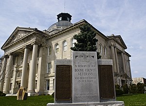 Boone County Courthouse in Lebanon | |
 Location within the U.S. state of Indiana | |
 Indiana's location within the U.S. | |
| Coordinates: 40°03′N 86°28′W / 40.05°N 86.47°W | |
| Country | |
| State | |
| Founded | 1 April 1830 (created) 1831 (organized) |
| Named for | Daniel Boone |
| Seat | Lebanon |
| Largest city | Zionsville |
| Area | |
| • Total | 423.25 sq mi (1,096.2 km2) |
| • Land | 422.91 sq mi (1,095.3 km2) |
| • Water | 0.34 sq mi (0.9 km2) 0.08%% |
| Population | |
| • Estimate (2019) | 67,843 |
| • Density | 158.4/sq mi (61.2/km2) |
| Congressional districts | 4th, 5th |
| Website | boonecounty |
| Indiana county number 6 | |

Boone County is a county in the U.S. state of Indiana. As of 2010, the population was 56,640.[1] The county seat (and the county's only incorporated city) is Lebanon.[2] Indiana's center of population is located in eastern Boone County, just northwest of the town of Sheridan in neighboring Hamilton County.[3]
History[]
In 1787, the fledgling United States defined the Northwest Territory, which included the area of present-day Indiana. In 1800, Congress separated Ohio from the Northwest Territory, designating the rest of the land as the Indiana Territory.[4] President Thomas Jefferson chose William Henry Harrison as the territory's first governor, and Vincennes was established as the territorial capital.[5] After the Michigan Territory was separated and the Illinois Territory was formed, Indiana was reduced to its current size and geography.[4] By December 1816 the Indiana Territory was admitted to the Union as a state.
Starting in 1794, Native American titles to Indiana lands were extinguished by usurpation, purchase, or war and treaty. The United States acquired land from the Native Americans in the 1809 treaty of Fort Wayne, and by the treaty of St. Mary's in 1818 considerably more territory became property of the government. This included the future Boone County, designating areas covered by the Delaware New Purchase.
Boone County was created by the state legislature on 1 April 1830, with Jamestown (which had been first settled that year) named as the initial county seat. The county was named for frontiersman Daniel Boone.[6] The interim county commissioners met on 1 May of the following year to identify a permanent seat of government, which by law had to be within 2 miles (3.2 km) of the county's center; the [future] city of Lebanon was selected to serve this purpose.[7]
Geography[]
Boone County lies near the center of the state. It is 24 miles (38.6 km) from east to west and 17.5 miles (28.2 km) from north to south. It contains about 418.5 square miles (108,500 hectares), two-thirds of which is in cultivation. Its central position, excellent soil, and available water power have been in its favor.[8] The highest point of the county (984 feet/300 meters ASL) is a small hill two miles (3.2 km) northeast of Lebanon.[9] The upper part of the county is drained by Sugar Creek, flowing westward into Montgomery County; the southwest part of the county is drained by Big Raccoon Creek, also flowing west-southwestward into Montgomery. The southeast part of the county is drained by Eagle Creek and its tributaries, flowing southward into Marion County.[10]
According to the 2010 census, the county has a total area of 423.25 square miles (1,096.2 km2), of which 422.91 square miles (1,095.3 km2) (or 99.92%) is land and 0.34 square miles (0.88 km2) (or 0.08%) is water.[11]
Adjacent counties[]
- Clinton County − north
- Hamilton County − east
- Marion County − southeast
- Hendricks County − south
- Montgomery County − west[12]
Cities[]
- Lebanon - county seat
Towns[]
- Advance
- Jamestown
- Thorntown
- Ulen
- Whitestown
- Zionsville
Unincorporated communities[]
- Big Springs
- Brendan Wood
- Dale
- Dover
- Eagle Village
- Eaglewood Estates[13]
- Elizaville
- Fayette
- Fox Hollow
- Gadsden
- Hazel College[14]
- Hazelrigg
- Herr
- Max
- Mechanicsburg
- Milledgeville
- New Brunswick
- Northfield
- Northfield Village[15]
- Pike
- Rosston
- Royalton
- Russell Lake[16]
- Shannondale (partial)
- Shepherd
- Stringtown
- Terhune
- The Woodlands
- Ward
- Waugh
Townships[]
Major highways[]
Airport[]
- KTYQ - Indianapolis Executive Airport
Railroads[]
- CSX Transportation
Education[]
Public schools in Boone County are administered by the Lebanon Community School Corporation, , Zionsville Community Schools, and Sheridan Community Schools.
Climate and weather[]
| Lebanon, Indiana | ||||||||||||||||||||||||||||||||||||||||||||||||||||||||||||
|---|---|---|---|---|---|---|---|---|---|---|---|---|---|---|---|---|---|---|---|---|---|---|---|---|---|---|---|---|---|---|---|---|---|---|---|---|---|---|---|---|---|---|---|---|---|---|---|---|---|---|---|---|---|---|---|---|---|---|---|---|
| Climate chart (explanation) | ||||||||||||||||||||||||||||||||||||||||||||||||||||||||||||
| ||||||||||||||||||||||||||||||||||||||||||||||||||||||||||||
| ||||||||||||||||||||||||||||||||||||||||||||||||||||||||||||
In recent years, average temperatures in Lebanon have ranged from a low of 18 °F (−8 °C) in January to a high of 86 °F (30 °C) in July, although a record low of −27 °F (−33 °C) was recorded in January 1994 and a record high of 112 °F (44 °C) was recorded in July 1936. Average monthly precipitation ranged from 2.35 inches (60 mm) in February to 4.54 inches (115 mm) in July.[17]
Government[]
The county government is a constitutional body, and is granted specific powers by the Constitution of Indiana, and by the Indiana Code.
County Council: The legislative branch of the county's government; controls and revenue collection in the county. Representatives are elected to four-year terms from county districts. They set salaries, the annual budget, and special spending. The council has limited authority to impose local taxes, in the form of an income and property tax that is subject to state level approval, excise taxes, and service taxes.[18][19]
Board of Commissioners: The executive body of the county; commissioners are elected county-wide to staggered four-year terms. One commissioner serves as president. The commissioners execute acts legislated by the council, collect revenue, and manage the county government.[18][19]
Court: The county maintains a small claims court that handles civil cases. The judge on the court is elected to a term of four years and must be a member of the Indiana Bar Association. The judge is assisted by a constable who is also elected to a four-year term. In some cases, court decisions can be appealed to the state level circuit court.[19]
County Officials: The county has other elected offices, including sheriff, coroner, auditor, treasurer, recorder, surveyor, and circuit court clerk. They are elected to four-year terms. Members elected to county government positions are required to declare a party affiliation and to be residents of the county.[19]
Boone County is part of Indiana's 4th and 5th congressional districts, Indiana Senate districts 21 and 23,[20] and Indiana House of Representatives districts 28, 38 and 87.[21]
Prior to 1940, Boone County was a Democratic-leaning swing county in presidential elections, backing the national winner in every election from 1912 to 1936. From 1940 on, it has become a Republican stronghold, with no Democratic presidential candidate since Lyndon B. Johnson in 1964 even managing to win forty percent of the county's votes.
Demographics[]
| Historical population | |||
|---|---|---|---|
| Census | Pop. | %± | |
| 1830 | 621 | — | |
| 1840 | 8,121 | 1,207.7% | |
| 1850 | 11,631 | 43.2% | |
| 1860 | 16,753 | 44.0% | |
| 1870 | 22,593 | 34.9% | |
| 1880 | 25,922 | 14.7% | |
| 1890 | 26,572 | 2.5% | |
| 1900 | 26,321 | −0.9% | |
| 1910 | 24,673 | −6.3% | |
| 1920 | 23,575 | −4.5% | |
| 1930 | 22,290 | −5.5% | |
| 1940 | 22,081 | −0.9% | |
| 1950 | 23,993 | 8.7% | |
| 1960 | 27,543 | 14.8% | |
| 1970 | 30,870 | 12.1% | |
| 1980 | 36,446 | 18.1% | |
| 1990 | 38,147 | 4.7% | |
| 2000 | 46,107 | 20.9% | |
| 2010 | 56,640 | 22.8% | |
| 2019 (est.) | 67,843 | [23] | 19.8% |
| US Decennial Census[24] 1790-1960[25] 1900-1990[26] 1990-2000[27] 2010-2013[1] | |||
2010 census[]
As of the 2010 United States Census, there were 56,640 people, 21,149 households, and 15,509 families in the county.[28] The population density was 133.9 inhabitants per square mile (51.7/km2). There were 22,754 housing units at an average density of 53.8 per square mile (20.8/km2).[11] The racial makeup of the county was 95.3% white, 1.7% Asian, 0.9% black or African American, 0.2% American Indian, 0.7% from other races, and 1.4% from two or more races. Those of Hispanic or Latino origin made up 2.2% of the population.[28] In terms of ancestry, 28.9% were German, 19.3% were English, 14.1% were Irish, and 9.0% were American.[29]
Of the 21,149 households, 38.8% had children under the age of 18 living with them, 61.1% were married couples living together, 8.4% had a female householder with no husband present, 26.7% were non-families, and 22.4% of all households were made up of individuals. The average household size was 2.65 and the average family size was 3.12. The median age was 38.6 years.[28]
The median income for a household in the county was $47,697 and the median income for a family was $81,401. Males had a median income of $57,251 versus $41,309 for females. The per capita income for the county was $38,696. About 6.1% of families and 7.1% of the population were below the poverty line, including 8.6% of those under age 18 and 5.6% of those age 65 or over.[30]
See also[]
- List of public art in Boone County, Indiana
- National Register of Historic Places listings in Boone County, Indiana
References[]
- ^ Jump up to: a b "Boone County QuickFacts". US Census Bureau. Archived from the original on 7 July 2011. Retrieved 17 September 2011.
- ^ "Find a County". National Association of Counties. Archived from the original on 31 May 2011. Retrieved 7 June 2011.
- ^ "Population and Population Centers by State: 2000". US Census Bureau. Archived from the original on 5 July 2013. Retrieved 30 June 2007.
- ^ Jump up to: a b "Government at Crossroads: An Indiana chronology". The Herald Bulletin. 5 January 2008. Retrieved 22 July 2009.
- ^ Brill, Marlene Targ (2005). Indiana. Marshall Cavendish. p. 35. ISBN 978-0-7614-2020-0.
- ^ Harden and Spahr 1887, p. 10.
- ^ Harden and Spahr 1887, p. 37.
- ^ Boone County Genealogy and History (Indiana Genealogy.org, accessed 1 November 2020)
- ^ High Point of Boone County, Indiana (PeakBagger.com, accessed 1 November 2020)
- ^ Boone County IN (Google Maps, accessed 1 November 2020)
- ^ Jump up to: a b "Population, Housing Units, Area, and Density: 2010 - County". US Census Bureau. Archived from the original on 12 February 2020. Retrieved 10 July 2015.
- ^ "History of Boone County". Boone County. Archived from the original on 24 March 2018. Retrieved 24 March 2018.
- ^ Eaglewood Estates IN (Google Maps, accessed 1 November 2020)
- ^ Hazel College/Center Township IN (Google Maps, accessed 1 November 2020)
- ^ Northfield Village/Lebanon IN (Google Maps, accessed 1 November 2020)
- ^ Russell Lake (Google Maps, accessed 1 November 2020)
- ^ Jump up to: a b "Monthly Averages for Lebanon, Indiana". The Weather Channel. Retrieved 27 January 2011.
- ^ Jump up to: a b Indiana Code. "Title 36, Article 2, Section 3". IN.gov. Retrieved 16 September 2008.
- ^ Jump up to: a b c d Indiana Code. "Title 2, Article 10, Section 2" (PDF). IN.gov. Retrieved 16 September 2008.
- ^ "Indiana Senate Districts". State of Indiana. Retrieved 1 November 2020.
- ^ "Indiana House Districts". State of Indiana. Retrieved 23 January 2011.
- ^ Leip, David. "Atlas of US Presidential Elections". uselectionatlas.org. Retrieved 14 May 2018.
- ^ "American FactFinder". Archived from the original on February 14, 2020. Retrieved April 22, 2019.
- ^ "US Decennial Census". US Census Bureau. Retrieved July 10, 2014.
- ^ "Historical Census Browser". University of Virginia Library. Retrieved July 10, 2014.
- ^ "Population of Counties by Decennial Census: 1900 to 1990". US Census Bureau. Retrieved July 10, 2014.
- ^ "Census 2000 PHC-T-4. Ranking Tables for Counties: 1990 and 2000" (PDF). US Census Bureau. Retrieved July 10, 2014.
- ^ Jump up to: a b c "Profile of General Population and Housing Characteristics: 2010 Demographic Profile Data". US Census Bureau. Archived from the original on 13 February 2020. Retrieved 10 July 2015.
- ^ "Selected Social Characteristics in the US – 2006-2010 American Community Survey 5-Year Estimates". US Census Bureau. Archived from the original on 14 February 2020. Retrieved 10 July 2015.
- ^ "Selected Economic Characteristics – 2006-2010 American Community Survey 5-Year Estimates". US Census Bureau. Archived from the original on 14 February 2020. Retrieved 10 July 2015.
Bibliography[]
- Harden, Samuel; Spahr, John (1887). Early Life and Times in Boone County, Indiana. Indianapolis: Carlon and Hollenbeck. Retrieved 31 May 2011.
- Leander Mead, Crist. History of Boone County, Indiana. Indianapolis: A. W. Bowen and Co. Retrieved 31 May 2011.
External links[]
- Boone County Community Network
- Lebanon Community School Corporation
- Western Boone County Community School Dist
- Zionsville Community Schools
- Boone County Government
| show Places adjacent to Boone County, Indiana |
|---|
| show Municipalities and communities of Boone County, Indiana, United States |
|---|
| show Indianapolis metropolitan area |
|---|

Coordinates: 40°03′N 86°28′W / 40.05°N 86.47°W
| show Authority control |
|---|
- Indiana counties
- Boone County, Indiana
- 1830 establishments in Indiana
- Populated places established in 1830
- Indianapolis metropolitan area