Charlestown Township, Chester County, Pennsylvania
Charlestown Township | |
|---|---|
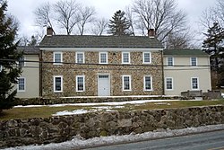 Martin-Little House, built 1735 | |
 Location of Pennsylvania in the United States | |
| Coordinates: 40°06′01″N 75°33′03″W / 40.10028°N 75.55083°WCoordinates: 40°06′01″N 75°33′03″W / 40.10028°N 75.55083°W | |
| Country | United States |
| State | Pennsylvania |
| County | Chester |
| Area | |
| • Total | 12.52 sq mi (32.44 km2) |
| • Land | 12.45 sq mi (32.25 km2) |
| • Water | 0.07 sq mi (0.19 km2) |
| Elevation | 223 ft (68 m) |
| Population (2010) | |
| • Total | 5,671 |
| • Estimate (2016)[2] | 5,745 |
| • Density | 461.45/sq mi (178.17/km2) |
| Time zone | UTC-5 (EST) |
| • Summer (DST) | UTC-4 (EDT) |
| Area code(s) | 610 |
| FIPS code | 42-029-12744 |
| Website | www |

Charlestown Township is a township in Chester County, Pennsylvania, United States. The population was 5,671 at the 2010 census.[3]
Part of the Valley Forge Christian College's campus, formerly the location of the Valley Forge General Hospital, is located in Charlestown Township. The other part is located in Schuylkill Township. The campus straddles the township line.
History[]
The Charlestown Village Historic District, Middle Pickering Rural Historic District, Martin-Little House, Oskar G. Stonorov House, John Williams Farm, and Jacob Wisner House are listed on the National Register of Historic Places.[4]
Geography[]
According to the United States Census Bureau, the township has a total area of 12.6 square miles (33 km2), of which, 12.5 square miles (32 km2) of it is land and 0.04 square miles (0.10 km2) of it (0.16%) is water.
Adjacent Townships
- Schuylkill Township (northeast)
- Tredyffrin Township (southeast)
- East Whiteland Township (south)
- West Whiteland Township (southwest)
- Uwchlan Township (west)
- West Pikeland Township (west)
- East Pikeland Township (north)
No incorporated municipalities are adjacent to Charlestown Township.
Demographics[]
| Historical population | |||
|---|---|---|---|
| Census | Pop. | %± | |
| 1930 | 720 | — | |
| 1940 | 726 | 0.8% | |
| 1950 | 854 | 17.6% | |
| 1960 | 1,931 | 126.1% | |
| 1970 | 3,528 | 82.7% | |
| 1980 | 2,770 | −21.5% | |
| 1990 | 2,754 | −0.6% | |
| 2000 | 4,051 | 47.1% | |
| 2010 | 5,671 | 40.0% | |
| 2020 | 6,001 | 5.8% | |
| [5][6] | |||
At the 2010 census, the township was 84.4% non-Hispanic White, 2.3% Black or African American, 0.2% Native American, 9.0% Asian, and 1.8% were two or more races. 2.6% of the population were of Hispanic or Latino ancestry [1].
| External video | |
|---|---|
As of the census[7] of 2000, there were 4,051 people, 1,340 households, and 1,003 families living in the township. The population density was 323.3 people per square mile (124.8/km2). There were 1,397 housing units at an average density of 111.5/sq mi (43.0/km2). The racial makeup of the township was 95.36% White, 1.56% African American, 0.17% Native American, 1.70% Asian, 0.02% Pacific Islander, 0.25% from other races, and 0.94% from two or more races. Hispanic or Latino of any race were 1.38% of the population.
There were 1,340 households, out of which 37.8% had children under the age of 18 living with them, 68.1% were married couples living together, 4.9% had a female householder with no husband present, and 25.1% were non-families. 20.4% of all households were made up of individuals, and 5.8% had someone living alone who was 65 years of age or older. The average household size was 2.73 and the average family size was 3.21.
In the township the population was spread out, with 25.8% under the age of 18, 10.8% from 18 to 24, 28.3% from 25 to 44, 25.2% from 45 to 64, and 9.9% who were 65 years of age or older. The median age was 37 years. For every 100 females there were 95.0 males. For every 100 females age 18 and over, there were 92.2 males.
The median income for a household in the township was $89,813, and the median income for a family was $101,922. Males had a median income of $77,386 versus $46,026 for females. The per capita income for the township was $41,878. About 1.4% of families and 2.1% of the population were below the poverty line, including 3.2% of those under age 18 and 2.1% of those age 65 or over.
Education[]
The township is served by Great Valley School District. Charlestown Elementary is in the township and is located at 2060 Charlestown Rd, Malvern, PA 19355.
References[]
- ^ "2016 U.S. Gazetteer Files". United States Census Bureau. Retrieved Aug 13, 2017.
- ^ "Population and Housing Unit Estimates". Retrieved June 9, 2017.
- ^ United States Census[dead link]
- ^ "National Register Information System". National Register of Historic Places. National Park Service. July 9, 2010.
- ^ "Archived copy". Archived from the original on 2019-04-09. Retrieved 2014-03-21.CS1 maint: archived copy as title (link)
- ^ "Census 2020".
- ^ "U.S. Census website". United States Census Bureau. Retrieved 2008-01-31.
External links[]
| Wikimedia Commons has media related to Charlestown Township, Chester County, Pennsylvania. |

- Townships in Chester County, Pennsylvania