East Whiteland Township, Chester County, Pennsylvania
East Whiteland Township | |
|---|---|
 | |
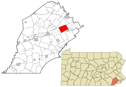 Location in Chester County and the state of Pennsylvania. | |
 Location of Pennsylvania in the United States | |
| Coordinates: 40°02′20″N 75°33′18″W / 40.03889°N 75.55500°WCoordinates: 40°02′20″N 75°33′18″W / 40.03889°N 75.55500°W | |
| Country | United States |
| State | Pennsylvania |
| County | Chester |
| Founded | 1704 |
| Government | |
| • Type | Board of Supervisors |
| • Supervisor | Sue Drummond |
| • Supervisor | Scott Lambert |
| • Supervisor | Richard Orlow |
| Area | |
| • Total | 11.00 sq mi (28.50 km2) |
| • Land | 10.94 sq mi (28.32 km2) |
| • Water | 0.07 sq mi (0.17 km2) |
| Elevation | 427 ft (130 m) |
| Population (2010) | |
| • Total | 10,650 |
| • Estimate (2016)[3] | 11,517 |
| • Density | 1,053.22/sq mi (406.64/km2) |
| Time zone | UTC-5 (EST) |
| • Summer (DST) | UTC-4 (EDT) |
| Area code(s) | 610 |
| FIPS code | 42-029-22056 |
| Website | www |

East Whiteland Township is a township in Chester County, Pennsylvania, United States. The population was 10,650 at the 2010 census. Mailing addresses associated with East Whiteland include Malvern, Frazer, and a small area of Exton.[4]
History[]
Founded in 1704, Whiteland Township was made up of what is today known as East and West Whiteland townships. The first European settlers were Welsh. The name Whiteland came from Whitford Garden in Flintshire, Wales.[5] Whiteland Township was divided into two townships in 1765.
Native Americans called the area "The Dark Valley" because of the numerous trees and undergrowth. During the American Revolution, Gen. George Washington and many of his troops camped at Malin Hall here. They were preparing for a September 16, 1777, encounter with British General William Howe. The Continental Army also camped near White Horse Inn on Swedesford Road. Because of bad weather, however, the "Battle of the Clouds" was never fought.
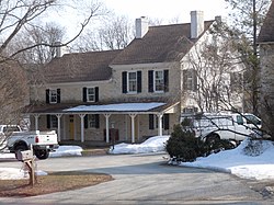
The Lapp Log House, St. Peter's Church in the Great Valley, Spring Mill Complex, and White Horse Tavern are listed on the National Register of Historic Places.[6]
Geography[]
According to the United States Census Bureau, the township has a total area of 11.0 square miles (28 km2), of which 0.04 square miles (0.10 km2), or 0.27%, is water. East Whiteland Township is located about 25 miles (40 km) west of Philadelphia.
The township has a ridge of hills along its northern and southern boundaries. These constitute the valley walls of the Great Valley, which runs generally west to east toward the Schuylkill River. In the center of the township, there is a somewhat uneven valley floor. The Great Valley contains a number of streams, including Valley Creek and Little Valley Creek, which is a narrow stream that goes across land and woodlands.[7]
Prominent transportation routes[]
The former main line of the Pennsylvania Railroad, currently owned and operated by Amtrak and also used by SEPTA, whose Paoli/Thorndale Line regional rail service, passes through, though no stations are located in the township.
Highways[]
- U.S. Route 202
- U.S. Route 30
- Pennsylvania Route 29
- Pennsylvania Route 401
- Pennsylvania Route 352
Demographics[]
| Historical population | |||
|---|---|---|---|
| Census | Pop. | %± | |
| 1930 | 1,334 | — | |
| 1940 | 1,290 | −3.3% | |
| 1950 | 1,740 | 34.9% | |
| 1960 | 5,078 | 191.8% | |
| 1970 | 7,242 | 42.6% | |
| 1980 | 8,468 | 16.9% | |
| 1990 | 8,398 | −0.8% | |
| 2000 | 9,333 | 11.1% | |
| 2010 | 10,650 | 14.1% | |
| 2016 (est.) | 11,517 | [3] | 8.1% |
| [8] | |||
At the 2010 census, the township was 77.1% non-Hispanic White, 3.3% Black or African American, 0.2% Native American, 11.6% Asian, and 1.5% were two or more races. 6.9% of the population were of Hispanic or Latino ancestry.[9]
As of the census[10] of 2000, there were 9,333 people, 3,254 households, and 2,255 families residing in the township. The population density was 848.6 people per square mile (327.6/km2). There were 3,460 housing units at an average density of 314.6/sq mi (121.4/km2). The racial makeup of the township was 89.57% White, 3.28% African American, 0.09% Native American, 4.98% Asian, 0.04% Pacific Islander, 0.73% from other races, and 1.31% from two or more races. Hispanic or Latino of any race were 2.42% of the population.
There were 3,254 households, out of which 34.9% had children under the age of 18 living with them, 58.3% were married couples living together, 7.7% had a female householder with no husband present, and 30.7% were non-families. 24.4% of all households were made up of individuals, and 5.8% had someone living alone who was 65 years of age or older. The average household size was 2.59 and the average family size was 3.13.
In the township the population was spread out, with 24.0% under the age of 18, 8.5% from 18 to 24, 29.6% from 25 to 44, 23.6% from 45 to 64, and 14.3% who were 65 years of age or older. The median age was 38 years. For every 100 females, there were 84.1 males. For every 100 females age 18 and over, there were 79.6 males.
The median income for a household in the township was $69,500, and the median income for a family was $75,818. Males had a median income of $55,969 versus $35,507 for females. The per capita income for the township was $30,258. About 3.9% of families and 4.7% of the population were below the poverty line, including 3.6% of those under age 18 and 6.5% of those age 65 or over.
Economy[]
This section needs additional citations for verification. (February 2011) |
Home to the Great Valley Corporate Center, the township also serves as U.S headquarters to several national and international firms including Siemens Health Services (formerly SMS), Vishay, SCT, Centocor and Aegon, as well as being home to numerous smaller businesses and retail shops. The Frazer Diner is a 1929 diner on U.S. Route 30 in Frazer.[citation needed]
Acme Markets has its headquarters in the township.[11][12]
Education[]
The Great Valley School District serves as the public education for the township. The public schools serving the township are Kathryn D. Markley Elementary, Great Valley Middle School, and Great Valley High School. Penn State has a graduate center here, Penn State Great Valley.[13] of Drexel University and Immaculata University are located in the township.[13][14][15]
Government[]
Board of Supervisors
East Whiteland Township is governed by a 3-member Board of Supervisors elected at-large, who each serve 6-year terms that include executive and legislative responsibilities. There is no mayor
References[]
- ^ "Board of Supervisors". East whiteland Township. Retrieved Feb 25, 2020.
- ^ "2016 U.S. Gazetteer Files". United States Census Bureau. Retrieved Aug 13, 2017.
- ^ Jump up to: a b "Population and Housing Unit Estimates". Retrieved June 9, 2017.
- ^ "Archived copy". Archived from the original on 2009-12-28. Retrieved 2009-09-02.CS1 maint: archived copy as title (link)
- ^ "Chester County Archives, Township & Borough Boundary History". Archived from the original on 2011-07-18. Retrieved 2008-11-30.
- ^ "National Register Information System". National Register of Historic Places. National Park Service. July 9, 2010.
- ^ "Archived copy". Archived from the original on 2006-07-07. Retrieved 2006-10-25.CS1 maint: archived copy as title (link)
- ^ "Archived copy". Archived from the original on 2019-04-09. Retrieved 2014-03-21.CS1 maint: archived copy as title (link)
- ^ https://www.usatoday.com/news/nation/census/profile/PA
- ^ "U.S. Census website". United States Census Bureau. Retrieved 2008-01-31.
- ^ "Acme Fast Facts Archived 2011-07-07 at the Wayback Machine." Acme Markets. Retrieved on February 14, 2011. "Division Office Headquarters at 75 Valley Stream Parkway, Malvern, PA 19355"
- ^ "Zoning Map". East Whiteland Township, Pennsylvania. Retrieved 2021-03-31.
- ^ Jump up to: a b "The Schools and Colleges Archived 2011-07-21 at the Wayback Machine." East Whiteland Township. Retrieved on February 13, 2011.
- ^ "East Whiteland township, Chester county, Pennsylvania[permanent dead link]." U.S. Census Bureau. Retrieved on June 16, 2009.
- ^ Home page. Immaculata University. Retrieved on June 16, 2009.
External links[]
| Wikimedia Commons has media related to East Whiteland Township, Chester County, Pennsylvania. |
| show Municipalities and communities of Chester County, Pennsylvania, United States |
|---|

| show Authority control |
|---|
- Populated places established in 1704
- Townships in Chester County, Pennsylvania
- Townships in Pennsylvania
- 1704 establishments in Pennsylvania