Eagleview, Pennsylvania
Eagleview, Pennsylvania | |
|---|---|
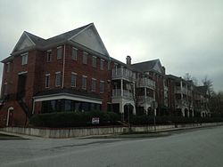 Wharton Boulevard and Cricket Lane in Eagleview | |
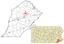 Location in Chester County and the state of Pennsylvania. | |
| Coordinates: 40°3′41″N 75°40′31″W / 40.06139°N 75.67528°WCoordinates: 40°3′41″N 75°40′31″W / 40.06139°N 75.67528°W | |
| Country | United States |
| State | Pennsylvania |
| County | Chester |
| Township | Uwchlan |
| Area | |
| • Total | 1.4 sq mi (3.5 km2) |
| • Land | 1.4 sq mi (3.5 km2) |
| • Water | 0.0 sq mi (0.0 km2) |
| Elevation | 450 ft (140 m) |
| Population (2010) | |
| • Total | 1,644 |
| • Density | 1,200/sq mi (470/km2) |
| Time zone | UTC-5 (Eastern (EST)) |
| • Summer (DST) | UTC-4 (EDT) |
| ZIP code | 19403 |
| Area code(s) | 610 |
| FIPS code | 42-20662 |

Eagleview is a census-designated place (CDP) in Uwchlan Township, Chester County, Pennsylvania, United States. The population was 1,644 at the 2010 census.[1] Conceptually, Eagleview was created as "... an old fashion town where you can work, live, shop, see your elders, and care for the young all in the same place."[2] According to a Landsat imagery, the Eagleview shopping center represents a medium density development that generated 400 square feet more living space per acre per the source than lower density developments also shown in the same imagery.[3] Stevens, in his book on a study of how to make communities safer in new urban developments uses Eagleview, along with Weatherstone, as sample data for comparing amount of green space for every acreage of development.[4] The community was listed in volume 6 of the New Urban News as an example of this new type of housing development.[5]

The shopping district inside the census designated place of the same name contains a mixed use community of stores, restaurants, and residential units with "walkable streets" and green spaces according to the official website.[6]
Geography[]
Eagleview is located at 40°3′41″N 75°40′31″W / 40.06139°N 75.67528°W[7] along the northwest border of Uwchlan Township. Pennsylvania Route 100 (Pottstown Pike) forms the northeastern edge of the CDP, including Route 100's connection to Exit 312 of the Pennsylvania Turnpike.
According to the United States Census Bureau, the CDP has a total area of 1.4 square miles (3.5 km2), all of it land.[8]
See also[]
- Weatherstone, Pennsylvania
References[]
- ^ "Profile of General Population and Housing Characteristics: 2010 Demographic Profile Data (DP-1): Eagleview CDP, Pennsylvania". United States Census Bureau. Retrieved August 20, 2012.
- ^ Harriet Hankin (2005). The New Workforce: Five Sweeping Trends That Will Shape Your Company's Future. ISBN 9780814428474.
- ^ Qihao Weng (3 October 2007). Remote Sensing of Impervious Surfaces. ISBN 9781420043754.
- ^ Mark Robert Stevens. Can Individual Planners Make Communities Safer? A Study of the Use of ... ISBN 9780549533023.
- ^ New Urban News - Volume 6 - Page 112. 2001.
- ^ The Hankin Group. "Eagleview Town Center". Archived from the original on 2013-04-09. Retrieved 2013-06-05.
- ^ US Geological Survey 7.5 minute topographic map series
- ^ "Geographic Identifiers: 2010 Demographic Profile Data (G001): Eagleview CDP, Pennsylvania". United States Census Bureau. Retrieved August 20, 2012.
External links[]
| Wikimedia Commons has media related to Eagleview, Pennsylvania. |

- Census-designated places in Chester County, Pennsylvania
- Lifestyle centers (retail)
- Census-designated places in Pennsylvania