Chesterville, Quebec
Chesterville | |
|---|---|
Municipality | |
 | |
| Nickname(s): Quebec's little Switzerland | |
 Location within Arthabaska RCM. | |
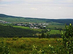
 Chesterville Location in southern Quebec. | |
| Coordinates: 45°58′N 71°49′W / 45.967°N 71.817°WCoordinates: 45°58′N 71°49′W / 45.967°N 71.817°W[1] | |
| Country | |
| Province | |
| Region | Centre-du-Québec |
| RCM | Arthabaska |
| Settled | 1835-1849 |
| Constituted | December 18, 1982 |
| Government | |
| • Mayor | Louis Lafleur |
| • Federal riding | Richmond—Arthabaska |
| • Prov. riding | Drummond–Bois-Francs |
| Area | |
| • Total | 117.00 km2 (45.17 sq mi) |
| • Land | 115.42 km2 (44.56 sq mi) |
| Population | |
| • Total | 891 |
| • Density | 7.7/km2 (20/sq mi) |
| • Pop 2006-2011 | |
| Time zone | UTC−5 (EST) |
| • Summer (DST) | UTC−4 (EDT) |
| Postal code(s) | G0P 1J0 |
| Area code(s) | 819 |
| Highways | |
| Website | www |

Chesterville is a municipality in the Arthabaska district of the Centre-du-Québec (Bois-Francs) region of Quebec, on Route 161 approximately 130 kilometres (81 mi) northeast of Montreal.
Geography[]
The town's mountainous terrain in the heart of the Canadian Appalachians has earned it the nickname of "Quebec's little Switzerland," and boasts a picturesque location adjacent to the northern Nicolet river.
History[]
The first settlers to the area arrived in 1835, but colonization actually began in spring 1849 with the establishment of a Catholic parish.
Demographics[]
The principal source of income in Chesterville is agriculture and forest exploitation.
Attractions[]
The free annual Symposium L'Accueil des Grands Peintres (art symposium) attracts many art lovers and features exhibits, artist conferences, workshops, local fare, and other cultural activities.
«Clairière - Art et Nature» is a 2 km forest path and natural amphitheatre dedicated to Professional site specific visual arts and musical concerts. Annual week-ends events are presented in August and September; they are open to the public.[4]
References[]
- ^ Reference number 137697 of the Commission de toponymie du Québec (in French)
- ^ Jump up to: a b Geographic code 39030 in the official Répertoire des municipalités (in French)
- ^ Jump up to: a b "(Code 2439030) Census Profile". 2011 census. Statistics Canada. 2012.
- ^ [1]
External links[]
- Anderson Machineries (agricultural and forestry machinery manufacturer)
- Centre-du-Québec touristic region
- Groupe Synergy Composites (developer of advanced composite products and technology for the utility vehicle and bus industries)
- Centre-du-Québec
- [2] Clairière - Art et Nature is an organization dedicated to creation and promotion of contemporary visual arts and music.
- Statistics Canada
| show Places adjacent to Chesterville, Quebec |
|---|
| show |
|---|
| show Authority control |
|---|
- Municipalities in Quebec
- Incorporated places in Centre-du-Québec