Saint-Valère, Quebec
show This article may be expanded with text translated from the corresponding article in French. (February 2016) Click [show] for important translation instructions. |
Saint-Valère | |
|---|---|
Municipality | |
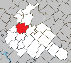 Location within Arthabaska RCM. | |
 Saint-Valère Location in southern Quebec. | |
| Coordinates: 46°04′N 72°06′W / 46.067°N 72.100°WCoordinates: 46°04′N 72°06′W / 46.067°N 72.100°W[1] | |
| Country | |
| Province | |
| Region | Centre-du-Québec |
| RCM | Arthabaska |
| Constituted | January 1, 1862 |
| Government | |
| • Mayor | Marc Plante |
| • Federal riding | Richmond—Arthabaska |
| • Prov. riding | Arthabaska |
| Area | |
| • Total | 108.80 km2 (42.01 sq mi) |
| • Land | 108.14 km2 (41.75 sq mi) |
| Population (2011)[3] | |
| • Total | 1,286 |
| • Density | 11.9/km2 (31/sq mi) |
| • Pop 2006-2011 | |
| Time zone | UTC−5 (EST) |
| • Summer (DST) | UTC−4 (EDT) |
| Postal code(s) | G0P 1M0 |
| Area code(s) | 819 |
| Highways | |
| Website | www |

Saint-Valère is a municipality located in the Centre-du-Québec region of Quebec, Canada.
References[]
- ^ Reference number 57736 of the Commission de toponymie du Québec (in French)
- ^ Jump up to: a b Geographic code 39135 in the official Répertoire des municipalités (in French)
- ^ Jump up to: a b "(Code 2439135) Census Profile". 2011 census. Statistics Canada. 2012.
| show Places adjacent to Saint-Valère, Quebec |
|---|
| show |
|---|
This Quebec location article is a stub. You can help Wikipedia by . |
Categories:
- Municipalities in Quebec
- Incorporated places in Centre-du-Québec
- Quebec geography stubs