Collins Reef
| Disputed island Other names: Johnson North Reef Đá Cô Lin (Vietnamese) Roxas Reef (Philippine English) Bahura ng Roxas (Filipino) 鬼喊礁 Guǐhǎn Jiāo (Chinese) | |
|---|---|
| Geography | |
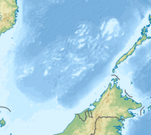 | |
| Location | South China Sea |
| Coordinates | 09°46′26″N 114°15′20″E / 9.77389°N 114.25556°ECoordinates: 09°46′26″N 114°15′20″E / 9.77389°N 114.25556°E |
| Archipelago | Spratly Islands |
| Administered by | |
| Vietnam | |
| District | Trường Sa District |
| Claimed by | |
| China | |
| Philippines | |
| Taiwan | |


Vietnamese structure on Collins Reef
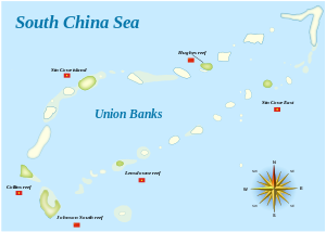
Map of the Union Banks
Collins Reef, also known as Johnson North Reef/Johnson Reef North; Vietnamese: Đá Cô Lin; Roxas Reef (Tagalog: Bahura ng Roxas); Mandarin Chinese: 鬼喊礁; pinyin: Guǐhǎn Jiāo, is a Vietnamese occupied and controlled reef and the westernmost feature of Union Banks Atoll near the centre of Dangerous Ground in the Spratly islands in the South China Sea.[1] It is also claimed by China (PRC), Taiwan (ROC), and the Philippines.
Location[]
Collins Reef lies at 9°46′26″N 114°15′20″E / 9.7738889°N 114.2555556°E (9°46′26″N 114°15′20″E / 9.7738889°N 114.2555556°E), to the northwest of Johnson South Reef, at the southwestern corner of the Union Banks.[2]

Chigua Jiao (Johnson South Reef)
Sinh Tồn (Sin Cowe)
Dōngmén Jiāo (Hughes Reef)
Whitson Reef
(Grierson Reef/ Sin Cowe East)
(Landsdowne Reef)
References[]
- ^ China Sea Pilot - Volume II - NP 31. Taunton: United Kingdom Hydrographic Office. 2012.
- ^ Diola, Camille (15 May 2014). "IN PHOTOS: China's reclamation on Mabini Reef". Philippine Star. Retrieved 19 May 2014.
| Confrontations |
| ||||||||||
|---|---|---|---|---|---|---|---|---|---|---|---|
| Regions | |||||||||||
| Occupied features | |||||||||||
| Unoccupied features | |||||||||||
| Related articles | |||||||||||
This Southeast Asia location article is a stub. You can help Wikipedia by . |
Categories:
- Reefs of the Spratly Islands
- Union Banks
- Asia geography stubs
- Southeast Asia stubs