Deqing County, Guangdong
Deqing
德庆县 Takhing | |
|---|---|
 Sanyuan Pagoda | |
 Location in Guangdong | |
| Coordinates: 23°08′38″N 111°47′10″E / 23.144°N 111.786°ECoordinates: 23°08′38″N 111°47′10″E / 23.144°N 111.786°E | |
| Country | People's Republic of China |
| Province | Guangdong |
| Prefecture-level city | Zhaoqing |
| Area | |
| • Total | 2,258 km2 (872 sq mi) |
| Time zone | UTC+8 (China Standard) |

| Deqing | |||
|---|---|---|---|
| Traditional Chinese | 德慶 | ||
| Simplified Chinese | 德庆 | ||
| Postal | Takhing | ||
| Literal meaning | Virtuous Celebration | ||
| |||
Deqing County, formerly romanized as Takhing,[a] is a county in western Guangdong province, China, under the administration of the prefecture-level city of Zhaoqing.
History[]
Under the Qing, Deqing County made up part of the commandery of Zhaoqing.[1]
Administrative divisions[]
| Name | Chinese (S) | Hanyu Pinyin | Population (2010)[2] | Area (km2) |
|---|---|---|---|---|
| 德城街道 | Déchéng Jiēdào | 58,878 | 17.5 | |
| town | 新圩镇 | Xīnxū Zhèn | 23,892 | 138 |
| Huilong town | 回龙镇 | Huílóng Zhèn | 17,401 | 132.2 |
| town | 官圩镇 | Guānxū Zhèn | 30,379 | 292 |
| town | 马圩镇 | Mǎxū Zhèn | 20,214 | 163.75 |
| town | 高良镇 | Gāoliáng Zhèn | 28,944 | 300 |
| town | 莫村镇 | Mòcūn Zhèn | 28,625 | 300 |
| town | 永丰镇 | Yǒngfēng Zhèn | 19,924 | 160 |
| town | 武垄镇 | Wǔlǒng Zhèn | 14,207 | 136 |
| town | 播植镇 | Bōzhí Zhèn | 15,308 | 115.3 |
| town | 凤村镇 | Fèngcūn Zhèn | 27,344 | 160 |
| town | 悦城镇 | Yuèchéng Zhèn | 31,544 | 221 |
| town | 九市镇 | Jiǔshì Zhèn | 24,551 | 152.6 |
- Defunct: Town & Town
Sights[]

Panlongxia Waterfall
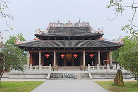
Deqing Confucian Temple
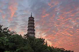
Sanyuan Pagoda
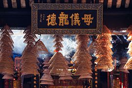
Longmu Temple in Yuecheng


Climate[]
| showClimate data for Deqing (1981−2010) |
|---|
Notes[]
References[]
Citations[]
- ^ Jump up to: a b Bolton & al. (1941), p. 262.
- ^ shi, Guo wu yuan ren kou pu cha ban gong; council, Guo jia tong ji ju ren kou he jiu ye tong ji si bian = Tabulation on the 2010 population census of the people's republic of China by township / compiled by Population census office under the state; population, Department of; statistics, employment statistics national bureau of (2012). Zhongguo 2010 nian ren kou pu cha fen xiang, zhen, jie dao zi liao (Di 1 ban. ed.). Beijing Shi: Zhongguo tong ji chu ban she. ISBN 978-7-5037-6660-2.
Bibliography[]
- Bolton, Kingsley; et al. (1941), Triad Societies, Vol. 5, Abingdon: Routledge, reprinted 2000.
| Wikimedia Commons has media related to Deqing County, Guangdong. |
| show Authority control |
|---|
This Guangdong location article is a stub. You can help Wikipedia by . |
Categories:
- Zhaoqing
- County-level divisions of Guangdong
- Guangdong geography stubs