From Wikipedia, the free encyclopedia
This article
needs additional citations for verification .
Please help by adding citations to reliable sources . Unsourced material may be challenged and removed.Find sources: – · · · scholar · JSTOR (August 2018 ) (Learn how and when to remove this template message )
County in Guangdong, People's Republic of China
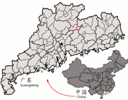
Xinfeng County (postal : Sunfung or Sinfeng; simplified Chinese : 新丰县 ; traditional Chinese : 新豐縣 ; pinyin : Xīnfēng Xiàn Guangdong Province , China. It is the southernmost county-level division of the prefecture-level city of Shaoguan .
Climate [ ]
show
Month
Jan
Feb
Mar
Apr
May
Jun
Jul
Aug
Sep
Oct
Nov
Dec
Year
Record high °C (°F)
28.4
30.8
33.0
33.7
35.6
37.2
38.3
37.9
37.0
35.8
34.4
29.5
38.3
Average high °C (°F)
17.6
18.1
20.6
25.0
28.7
30.7
32.8
32.8
30.8
28.2
24.0
19.6
25.7
Daily mean °C (°F)
11.5
13.2
16.2
20.8
24.1
26.2
27.4
27.3
25.4
21.9
17.1
12.5
20.3
Average low °C (°F)
7.5
9.9
13.1
17.9
21.0
23.3
24.0
24.0
22.0
17.7
12.5
7.8
16.7
Record low °C (°F)
−2.8
−1.2
−0.2
6.8
11.7
14.2
19.5
20.1
13.1
5.7
0.2
−5.3
−5.3
Average precipitation mm (inches)
57.7
95.0
163.4
234.2
274.5
322.0
235.5
210.0
141.7
42.2
40.9
38.8
1,855.9
Average relative humidity (%)
75
80
83
84
84
85
82
82
82
77
74
72
80
Source: China Meteorological Data Service Center
show Authority control General National libraries
Categories :
County-level divisions of Guangdong Shaoguan Guangdong geography stubs Hidden categories:
Articles needing additional references from August 2018 All articles needing additional references Articles with short description Short description is different from Wikidata Articles containing Chinese-language text Coordinates on Wikidata Articles containing simplified Chinese-language text Articles containing traditional Chinese-language text Articles with VIAF identifiers Articles with LCCN identifiers Articles with WorldCat-VIAF identifiers All stub articles