Dorbod Mongol Autonomous County
Dorbod County | |
|---|---|
| 杜尔伯特蒙古族自治县 · ᠳᠥᠷᠪᠡᠳ ᠮᠣᠩᠭᠣᠯ ᠥᠪᠡᠷᠲᠡᠭᠡᠨ ᠵᠠᠰᠠᠬᠤ ᠰᠢᠶᠠᠨ Dorbod Mongol Autonomous County | |
 | |
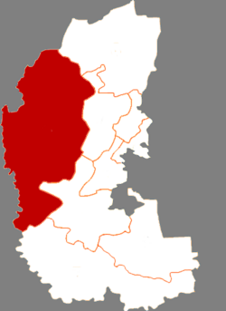 Dorbod in Daqing | |
 Daqing in Heilongjiang | |
| Coordinates: 46°51′46″N 124°26′33″E / 46.8628°N 124.4426°ECoordinates: 46°51′46″N 124°26′33″E / 46.8628°N 124.4426°E | |
| Country | People's Republic of China |
| Province | Heilongjiang |
| Prefecture-level city | Daqing |
| Time zone | UTC+8 (China Standard) |

Dorbod Mongol Autonomous County (simplified Chinese: 杜尔伯特蒙古族自治县; traditional Chinese: 杜爾伯特蒙古族自治縣; pinyin: Dù'ěrbótè měnggǔzú Zìzhìxiàn; Mongolian: ᠳᠥᠷᠪᠡᠳ ᠮᠣᠩᠭᠣᠯ ᠥᠪᠡᠷᠲᠡᠭᠡᠨ ᠵᠠᠰᠠᠬᠤ ᠰᠢᠶᠠᠨ ) is a county in the west of Heilongjiang
province, China, bordering Jilin province to the southwest. It is under the jurisdiction of the prefecture-level city of Daqing. Formerly[when?] known as Dorbod Banner.[citation needed]
Demographics[]
The population of the county was 243,829 in 1999.[1]
It is named after the Dörbed Mongols.
References[]
- ^ (in English) National Population Statistics Materials by County and City - 1999 Period, in China County & City Population 1999, Harvard China Historical GIS
External links[]
- (in Chinese) Government site - Google translation
See also[]

| show Authority control |
|---|
This Heilongjiang location article is a stub. You can help Wikipedia by . |
Categories:
- Administrative subdivisions of Heilongjiang
- Mongol autonomous counties
- Daqing
- Heilongjiang geography stubs